File:GrantPlanSWVA1864May.png
Jump to navigation
Jump to search
Size of this preview: 640 × 599 pixels. Other resolutions: 256 × 240 pixels | 787 × 737 pixels.
Original file (787 × 737 pixels, file size: 1.11 MB, MIME type: image/png)
Captions
Captions
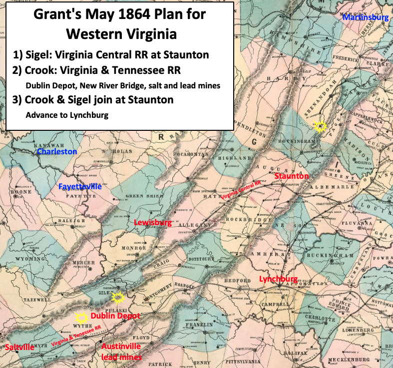
Grant's plan to attack the Confederate railroads that supplied Lee's army
Summary
[edit]
| Description |
English: New Union Army leader U.S. Grant's strategy in Virginia was to attack the strongest Confederate Army, Robert E. Lee's Army of Northern Virginia, from multiple fronts. The map shows the plan for western Virginia. The railroads that supplied Lee's army were Union targets, including the Virginia & Tennessee Railroad and the Virginia Central Railroad. This would cause Lee to send troops, that could be defending Richmond, to western Virginia to defend the railroads. |
| Date | |
| Source | This is a crop of an 1861 map created by O.N. Snow & Co. The entire map can be found in the Library of Congress here, and shows Virginia, Delaware, Maryland & West Virginia. Text box and blue and red labels were added by TwoScarsUp based on descriptions in the book Lee's Endangered Left by Richard R. Duncan. Because this map was originally created in 1861, it does not show Bland County—which was created in 1861 from portions of Wythe, Tazewell, and Giles counties. |
| Author | O.N. Snow with modifications by TwoScarsUp |
Licensing
[edit]
This work is in the public domain in the United States because it was published (or registered with the U.S. Copyright Office) before January 1, 1929.
Public domain works must be out of copyright in both the United States and in the source country of the work in order to be hosted on the Commons. If the work is not a U.S. work, the file must have an additional copyright tag indicating the copyright status in the source country.
Note: This tag should not be used for sound recordings. |
|
This work is in the public domain in its country of origin and other countries and areas where the copyright term is the author's life plus 70 years or fewer. | |
| This file has been identified as being free of known restrictions under copyright law, including all related and neighboring rights. | |
File history
Click on a date/time to view the file as it appeared at that time.
| Date/Time | Thumbnail | Dimensions | User | Comment | |
|---|---|---|---|---|---|
| current | 20:04, 10 July 2024 | | 787 × 737 (1.11 MB) | TwoScarsUp (talk | contribs) | Uploaded a work by O.N. Snow with modifications by TwoScarsUp from This is a crop of an 1861 map created by O.N. Snow & Co. The entire map can be found in the Library of Congress [https://www.loc.gov/item/lva0000091/ here], and shows Virginia, Delaware, Maryland & West Virginia. Text box and blue and red labels were added by TwoScarsUp based on descriptions in the book Lee's Endangered Left by Richard R. Duncan. with UploadWizard |
You cannot overwrite this file.
File usage on Commons
The following page uses this file:
File usage on other wikis
The following other wikis use this file:
- Usage on en.wikipedia.org