File:Geologic map Armorican Massif FR.svg
Jump to navigation
Jump to search

Size of this PNG preview of this SVG file: 792 × 600 pixels. Other resolutions: 317 × 240 pixels | 634 × 480 pixels | 1,015 × 768 pixels | 1,280 × 969 pixels | 2,560 × 1,938 pixels | 1,770 × 1,340 pixels.
Original file (SVG file, nominally 1,770 × 1,340 pixels, file size: 962 KB)
Captions
Captions
Add a one-line explanation of what this file represents
Summary
[edit]
| Description |
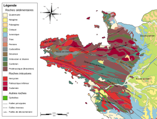
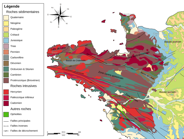
Brezhoneg: Kartenn c'heologel Torosad Arvorig e galleg. Français : Carte géologique du massif armoricain, France. |
| Date | (UTC) |
| Source |
Geologic_map_Armorican_Massif_EN.svg, itself from :
|
| Author |
|
| Permission (Reusing this file) |
Own work |
| Other versions |
  |
Licensing
[edit]
I, the copyright holder of this work, hereby publish it under the following licenses:

|
Permission is granted to copy, distribute and/or modify this document under the terms of the GNU Free Documentation License, Version 1.2 or any later version published by the Free Software Foundation; with no Invariant Sections, no Front-Cover Texts, and no Back-Cover Texts. A copy of the license is included in the section entitled GNU Free Documentation License. |
This file is licensed under the Creative Commons Attribution-Share Alike 3.0 Unported, 2.5 Generic, 2.0 Generic and 1.0 Generic license.
- You are free:
- to share – to copy, distribute and transmit the work
- to remix – to adapt the work
- Under the following conditions:
- attribution – You must give appropriate credit, provide a link to the license, and indicate if changes were made. You may do so in any reasonable manner, but not in any way that suggests the licensor endorses you or your use.
- share alike – If you remix, transform, or build upon the material, you must distribute your contributions under the same or compatible license as the original.
You may select the license of your choice.
File history
Click on a date/time to view the file as it appeared at that time.
| Date/Time | Thumbnail | Dimensions | User | Comment | |
|---|---|---|---|---|---|
| current | 17:11, 1 March 2012 | | 1,770 × 1,340 (962 KB) | DavidL (talk | contribs) | Correction orthographique |
| 07:45, 9 November 2009 |  | 1,770 × 1,340 (986 KB) | Woudloper (talk | contribs) | {{Information |Description={{en|1={{fr|1=Carte géologique du massif armoricain, France.}} |Source=Geologic_map_Armorican_Massif_EN.svg, itself from : *{{Small-caps|Service Géo |
You cannot overwrite this file.
File usage on Commons
The following 2 pages use this file:
File usage on other wikis
The following other wikis use this file:
- Usage on bg.wikipedia.org
- Usage on de.wikipedia.org
- Usage on eo.wikipedia.org
- Usage on fr.wikipedia.org
- Normandie
- Angers
- Plogoff
- Plougastel-Daoulas
- Plouguerneau
- Ploumoguer
- Plounévez-Lochrist
- Primelin
- Bannalec
- Brignogan-Plages
- Châteaulin
- Cléder
- Huelgoat
- Kersaint-Plabennec
- Le Conquet
- Locmaria-Plouzané
- Mespaul
- Roscanvel
- Saint-Renan
- Tréglonou
- Cerisy-la-Forêt
- Géographie de la Bretagne
- Néant-sur-Yvel
- Hœdic
- Pays de Léon
- Pointe du Raz
- Augan
- Campénéac
- Cléguérec
- Réminiac
- Sainte-Brigitte
- Questembert
- Vitré (Ille-et-Vilaine)
- Ménéac
- Quintin
- Saint-Gilles-Vieux-Marché
- Baie des Trépassés
- Montfort-sur-Meu
- Craon (Mayenne)
- Forêt de Paimpont
- Bas-Poitou
- Le Gouray
- Baulon
- Bruz
- Grand-Fougeray
View more global usage of this file.