File:France map Lambert-93 topographic-ancient Roman roads.svg
Jump to navigation
Jump to search

Size of this PNG preview of this SVG file: 644 × 600 pixels. Other resolutions: 258 × 240 pixels | 515 × 480 pixels | 825 × 768 pixels | 1,099 × 1,024 pixels | 2,199 × 2,048 pixels | 1,766 × 1,645 pixels.
Original file (SVG file, nominally 1,766 × 1,645 pixels, file size: 1.6 MB)
Captions
Captions
Add a one-line explanation of what this file represents
Summary
[edit]
| Description |
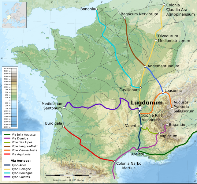
Français : Carte topographique représentant les principales voies romaines construites en Gaule sous l'Empire Romain. |
| Date | |
| Source | Own work from a topographic map from Eric Gaba, and from data provided by www.omnesviae.org |
| Author | Eric Gaba, Flappiefh |
| Other versions |
|
Licensing
[edit]
I, the copyright holder of this work, hereby publish it under the following licenses:

|
Permission is granted to copy, distribute and/or modify this document under the terms of the GNU Free Documentation License, Version 1.2 or any later version published by the Free Software Foundation; with no Invariant Sections, no Front-Cover Texts, and no Back-Cover Texts. A copy of the license is included in the section entitled GNU Free Documentation License. |
This file is licensed under the Creative Commons Attribution-Share Alike 4.0 International, 3.0 Unported, 2.5 Generic, 2.0 Generic and 1.0 Generic license.
- You are free:
- to share – to copy, distribute and transmit the work
- to remix – to adapt the work
- Under the following conditions:
- attribution – You must give appropriate credit, provide a link to the license, and indicate if changes were made. You may do so in any reasonable manner, but not in any way that suggests the licensor endorses you or your use.
- share alike – If you remix, transform, or build upon the material, you must distribute your contributions under the same or compatible license as the original.
You may select the license of your choice.
File history
Click on a date/time to view the file as it appeared at that time.
| Date/Time | Thumbnail | Dimensions | User | Comment | |
|---|---|---|---|---|---|
| current | 22:18, 6 December 2013 | | 1,766 × 1,645 (1.6 MB) | Ciaurlec (talk | contribs) | Correction en légende: Aggripa->Agrippa |
| 11:45, 20 September 2013 |  | 1,766 × 1,645 (1.6 MB) | Sting (talk | contribs) | Correction : inversion Andemantunnum (Langres) <=> Cavillonum (Chalon-sur-Saône) | |
| 17:15, 11 July 2012 |  | 1,766 × 1,645 (1.6 MB) | Flappiefh (talk | contribs) |
You cannot overwrite this file.
File usage on Commons
The following 4 pages use this file:
File usage on other wikis
The following other wikis use this file:
- Usage on ar.wikipedia.org
- Usage on arz.wikipedia.org
- Usage on ca.wikipedia.org
- Usage on cs.wikipedia.org
- Usage on de.wikipedia.org
- Usage on el.wikipedia.org
- Usage on en.wikipedia.org
- Usage on es.wikipedia.org
- Usage on eu.wikipedia.org
- Usage on fr.wikipedia.org
- Lyon pendant l'Antiquité
- Voie romaine
- Histoire de la Drôme
- Voie romaine d'Agrippa
- Puch-d'Agenais
- Via Aurelia
- Histoire de l'Yonne
- Via Aquitania
- Liste de voies romaines
- Voies romaines en Gaule
- Histoire d'Arles à l'époque romaine
- Histoire de l'Occitanie
- Wikipédia:Atelier graphique/Cartes/Archives/juillet 2012
- Utilisateur:Le plombier du désert/Brouillon
- Histoire de la plomberie
- Voie romaine de Reims à Bavay
- Voie romaine de Reims à Langres
- Voie romaine de Reims à Soissons
- Usage on ga.wikipedia.org
- Usage on hu.wikipedia.org
- Usage on it.wikipedia.org
View more global usage of this file.