File:Extent of Bedford Shale and Berea Sandstone - Ohio and N Kentucky.jpg
Jump to navigation
Jump to search

Size of this preview: 431 × 599 pixels. Other resolutions: 173 × 240 pixels | 345 × 480 pixels | 552 × 768 pixels | 737 × 1,024 pixels | 1,474 × 2,048 pixels | 9,750 × 13,550 pixels.
Original file (9,750 × 13,550 pixels, file size: 17.12 MB, MIME type: image/jpeg)
Captions
Captions
Add a one-line explanation of what this file represents
Summary
[edit]
| Warning | The original file is very high-resolution. It might not load properly or could cause your browser to freeze when opened at full size. |
|---|
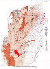
| Description |
English: Isopach map showing the extent of the Bedford Shale, Berea Sandstone, and associated shales and sandstones in Ohio and northern Kentucky in the United States. |
| Date | |
| Source | https://pubs.usgs.gov/pp/0259/plate-01.pdf |
| Author | Pepper, James F.; DeWitt, Wallace, Jr.; Demarest, David F. (1954). Geology of the Bedford Shale and Berea Sandstone in the Appalachian Basin. Geologic Survey Professional Paper 259. Washington, D.C.: U.S. Government Printing Office, Plate 1. |
Licensing
[edit]
This image is in the public domain in the United States because it only contains materials that originally came from the United States Geological Survey, an agency of the United States Department of the Interior. For more information, see the official USGS copyright policy.
|
File history
Click on a date/time to view the file as it appeared at that time.
| Date/Time | Thumbnail | Dimensions | User | Comment | |
|---|---|---|---|---|---|
| current | 13:10, 26 March 2018 | | 9,750 × 13,550 (17.12 MB) | Tim1965 (talk | contribs) | User created page with UploadWizard |
You cannot overwrite this file.
File usage on Commons
There are no pages that use this file.
File usage on other wikis
The following other wikis use this file:
- Usage on en.wikipedia.org