Category:Isopach maps
Jump to navigation
Jump to search
Media in category "Isopach maps"
The following 26 files are in this category, out of 26 total.
-
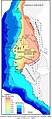 Bassin sénégalo-mauritano-guinéen.jpg 1,415 × 3,238; 814 KB
-

-
 Eagle Ford play footprint (16316823326).png 430 × 321; 139 KB
-
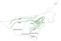
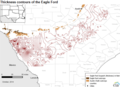
 Elevation contours of the top of the Eagle Ford (16156886757).png 465 × 348; 130 KB
-
 Extent of Bedford Shale and Berea Sandstone - Ohio and N Kentucky.jpg 9,750 × 13,550; 17.12 MB
-
-
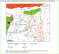
 Geologic Map for the Anadarko Basin.png 1,013 × 795; 194 KB
-
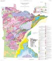 Geologic Map of Minnesota- Bedrock Geology (2011).pdf 7,500 × 8,737; 10.37 MB
-
 Graptolitic argillite in northern Estonia.png 897 × 479; 55 KB
-
 Isopach sheet 7 33.jpg 3,596 × 2,594; 1.94 MB
-
 Isopach Sheet7c 33.jpg 694 × 1,101; 201 KB
-
 Isopach Sheet7d 33.jpg 1,097 × 1,155; 231 KB
-
 Marcellus shale isopach map 2019 DE.png 3,507 × 2,480; 5.53 MB
-
 Mississippi Embayment Top Cretaceous Contour Map.png 1,199 × 1,000; 773 KB
-
 Nigerdeltapetroleumsys.gif 731 × 545; 60 KB
-
 North China phanerozoic thickness contour.png 599 × 582; 46 KB
-
 North China phanerozoic thickness.png 543 × 368; 43 KB
-
 Ssxiso.gif 924 × 603; 39 KB
-
 Structure map of the Point Pleasant formation (26729708861).jpg 3,507 × 2,480; 906 KB
-
 Structure map of the Utica formation (26796542625).jpg 3,507 × 2,480; 948 KB
-
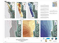
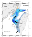 Taiwan Strait Sediment Distribution.png 1,304 × 1,508; 1.05 MB
-
 Thickness contours of the Eagle Ford (16341024471).png 485 × 351; 155 KB
-
 Thickness map of the combined Utica-Point Pleasant interval (26796552265).jpg 3,507 × 2,480; 852 KB
-
 Thickness map of the Point Pleasant formation (26729715011).jpg 3,507 × 2,480; 842 KB
-
 Thickness map of the Utica formation (26191453814).jpg 3,507 × 2,480; 798 KB
-
 Yinggehai basin isopach.png 1,465 × 1,975; 403 KB


.png)
.png)


.jpg)
.jpg)

.png)
.jpg)
.jpg)
.jpg)
