File:Duchy of Carinthia-1000 AD.svg

Original file (SVG file, nominally 565 × 520 pixels, file size: 728 KB)
Captions
Captions
Created by User:ZyMOS for Wiki Atlas of World History
Derived from: File:Italy_1000_AD.svg
Summary
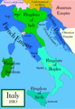
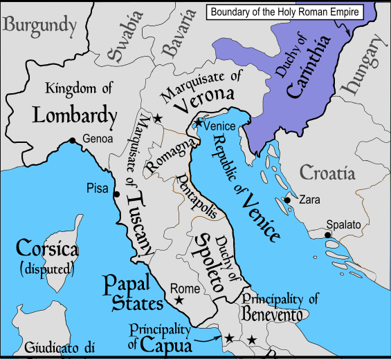
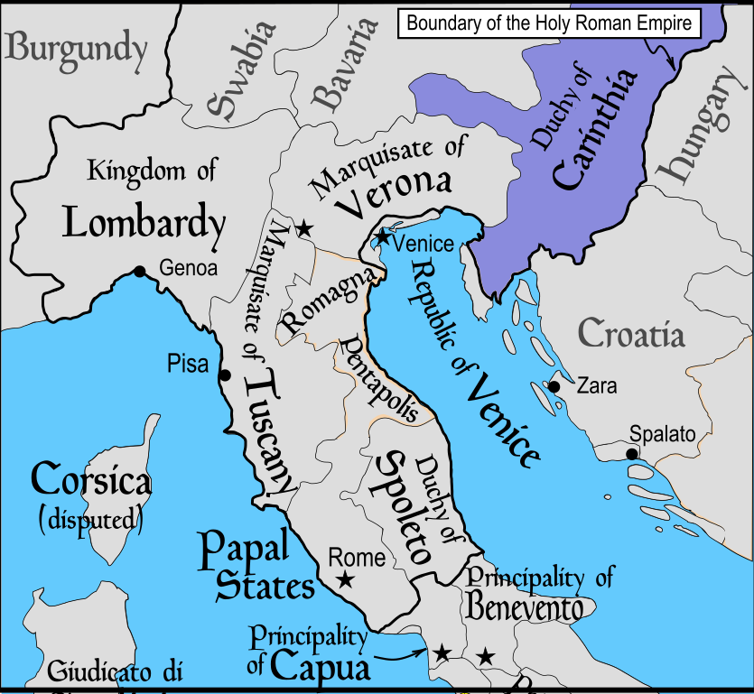
[edit]en: Political map of Italy in 1000 AD (CE). Created by MapMaster.
Part of a series of maps on the history of Italy:
-
 1084 AD
 -
 1494 AD
 -
 1796 AD
 -
 1810 AD


Other versions
[edit]
Czech
English
Italiano
Deutsch
Español
Hebrew
Polish
Russian
Hungarian
French
References
[edit]
- Bjorklund, Oddvar; Holmboe, Haakon; Rohr, Anders (1970) Historical Atlas of the World, Barnes & Noble, NY, SBN: 389-00253-4.
- This map from Allyn & Bacon, Longman, textbook publishers.
- This map of the w:en:Holy Roman Empire
- A map from Attilios
- This map of 1050 AD Italy, from the 1923 The Historical Atlas by William R. Shepherd
- This map of 1000 AD Italy from Fordham University, adapted from Muir's Historical Atlas, (1911).
In addition, a number of other sources were consulted in an effort to determine the following matters:
- The extent of Venetian control over the cities of Dalmatia such as Zara and Spalato. Although the Venetians had been pushed off the mainland earlier, in the period around the year 1000, the Venetians made an effort to recover these cities.
- The extent of Saracen control over Corsica and Sardinia. Information is sparse. The apparent situation is that the Muslims had several bases on the coasts of these islands, but did not control the countryside (such as they did in Sicily).
- Whether or not the principalities of Capua and Benevento were separate states in the year 1000. Based on lists of their rulers (various Pandulfs and Landulfs), the answer seems to be "yes".
- Who controlled the Balkans on the southeastern border of the Kingdom of Croatia. Candidates include Bulgaria, the Byzantine Empire, Croatia, and Serbia.
As noted, there is significant disagreement among sources on these questions.
This map was commissioned by Attilios, and there is also a discussion to be found on MapMaster's English talk page.
Licensing
[edit]

|
Permission is granted to copy, distribute and/or modify this document under the terms of the GNU Free Documentation License, Version 1.2 or any later version published by the Free Software Foundation; with no Invariant Sections, no Front-Cover Texts, and no Back-Cover Texts. A copy of the license is included in the section entitled GNU Free Documentation License. |
| This file is licensed under the Creative Commons Attribution-Share Alike 3.0 Unported license. | ||
| ||
| This licensing tag was added to this file as part of the GFDL licensing update. |
derivative works
[edit]
Derivative works of this file: Italya MS 1000.svg
File history
Click on a date/time to view the file as it appeared at that time.
| Date/Time | Thumbnail | Dimensions | User | Comment | |
|---|---|---|---|---|---|
| current | 05:17, 13 March 2011 | | 565 × 520 (728 KB) | ZyMOS (talk | contribs) | ---- Created by User:ZyMOS for [http://historyatlas.wikia.com/wiki/ Wiki Atlas of World History] ---- Derived from: http://commons.wikimedia.org/wiki/File:Italy_1000_AD.svg == {{int:filedesc}} == '''en:''' Political map of Italy in 1000 AD (CE). Crea |
You cannot overwrite this file.
File usage on Commons
There are no pages that use this file.
File usage on other wikis
The following other wikis use this file:
- Usage on el.wikipedia.org
- Usage on en.wikipedia.org
- Usage on et.wikipedia.org
- Usage on ja.wikipedia.org
- Usage on vls.wikipedia.org
- Maps of the history of the Italian Peninsula
- Maps of the territories of the Holy Roman Empire
- Maps of the Republic of Venice
- March of Verona
- Maps of the Byzantine Empire
- Principate of Salerno
- Maps showing 10th-century history
- SVG maps of the history of Italy
- Maps of 10th-century Italy
- Maps of the Duchy of Carinthia