File:Donau BV043563753.jpg
Jump to navigation
Jump to search

Size of this preview: 240 × 598 pixels. Other resolutions: 96 × 240 pixels | 192 × 480 pixels | 308 × 768 pixels | 411 × 1,024 pixels | 821 × 2,048 pixels | 3,831 × 9,548 pixels.
Original file (3,831 × 9,548 pixels, file size: 3.07 MB, MIME type: image/jpeg)
Captions
Captions
Add a one-line explanation of what this file represents
Summary
[edit]| Title |
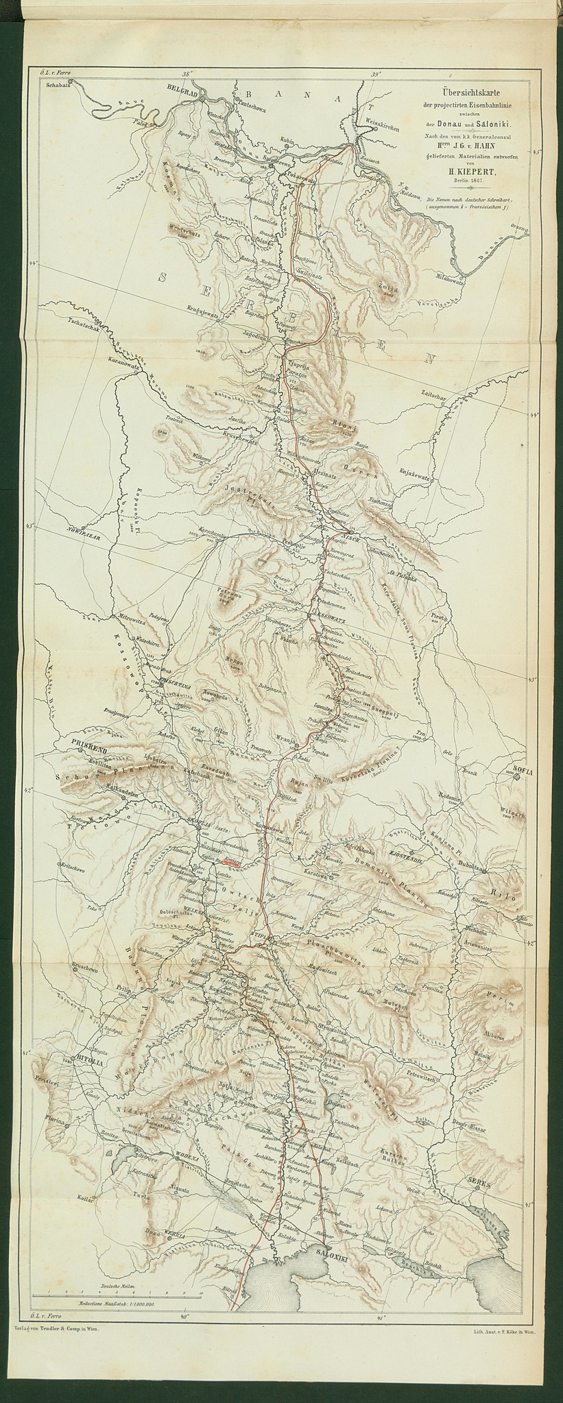
Übersichtskarte der projectirten Eisenbahnlinie zwischen der Donau und Saloniki |
|||||||||||||||||||||||
| Description |
Deutsch: DonauEisenbahnnetz |
|||||||||||||||||||||||
| Date | ||||||||||||||||||||||||
| Source | Leibniz-Institut für Ost- und Südosteuropaforschung (IOS) GeoPortOst | |||||||||||||||||||||||
| Creator |
Johann Georg von Hahn |
|||||||||||||||||||||||
| Permission (Reusing this file) |
|
|||||||||||||||||||||||
| Geotemporal data | ||||||||||||||||||||||||
| Date depicted | ||||||||||||||||||||||||
| Map location | Donau | |||||||||||||||||||||||
| Map type | Topografische Karte | |||||||||||||||||||||||
| Scale | 1:1000000 | |||||||||||||||||||||||
| Bounding box |
|
|||||||||||||||||||||||
| Georeferencing | ||||||||||||||||||||||||
| Bibliographic data | ||||||||||||||||||||||||
| Map sheet | Beigabe | |||||||||||||||||||||||
| Language | German | |||||||||||||||||||||||
| Archival data | ||||||||||||||||||||||||
| Collection |
|
|||||||||||||||||||||||
| Accession number |
BV043563753 |
|||||||||||||||||||||||

Licensing
[edit]
|
This work is in the public domain in its country of origin and other countries and areas where the copyright term is the author's life plus 70 years or fewer. | |
| This file has been identified as being free of known restrictions under copyright law, including all related and neighboring rights. | |
File history
Click on a date/time to view the file as it appeared at that time.
| Date/Time | Thumbnail | Dimensions | User | Comment | |
|---|---|---|---|---|---|
| current | 16:08, 19 February 2019 | 3,831 × 9,548 (3.07 MB) | H.bauer26 (talk | contribs) | pattypan 18.02 |
You cannot overwrite this file.
File usage on Commons
There are no pages that use this file.