File:Cultura di Canegrate map.svg
Jump to navigation
Jump to search

Size of this PNG preview of this SVG file: 558 × 447 pixels. Other resolutions: 300 × 240 pixels | 599 × 480 pixels | 959 × 768 pixels | 1,278 × 1,024 pixels | 2,557 × 2,048 pixels.
Original file (SVG file, nominally 558 × 447 pixels, file size: 692 KB)
Captions
Captions
Add a one-line explanation of what this file represents
Summary
[edit]
| Description |
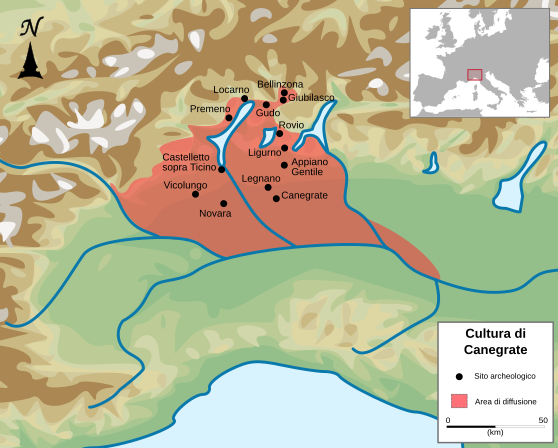
Italiano: Area della diffusione della Cultura di Canegrate. |
| Date | |
| Source |
Own work
 |
| Author | Ruthven |
| Other versions | |
| SVG development | This vector image was created with Inkscape. |

|
This SVG file contains embedded text that can be translated into your language, using any capable SVG editor, text editor or the SVG Translate tool. For more information see: About translating SVG files. |
Licensing
[edit]
I, the copyright holder of this work, hereby publish it under the following license:
This file is licensed under the Creative Commons Attribution-Share Alike 4.0 International license.
- You are free:
- to share – to copy, distribute and transmit the work
- to remix – to adapt the work
- Under the following conditions:
- attribution – You must give appropriate credit, provide a link to the license, and indicate if changes were made. You may do so in any reasonable manner, but not in any way that suggests the licensor endorses you or your use.
- share alike – If you remix, transform, or build upon the material, you must distribute your contributions under the same or compatible license as the original.
File history
Click on a date/time to view the file as it appeared at that time.
| Date/Time | Thumbnail | Dimensions | User | Comment | |
|---|---|---|---|---|---|
| current | 08:33, 29 October 2015 | | 558 × 447 (692 KB) | Ruthven (talk | contribs) | didascalia cambiata in 'sito archeologico' |
| 16:23, 28 October 2015 |  | 558 × 447 (694 KB) | Ruthven (talk | contribs) | border removed | |
| 16:11, 28 October 2015 |  | 558 × 447 (686 KB) | Ruthven (talk | contribs) | User created page with UploadWizard |
You cannot overwrite this file.
File usage on Commons
There are no pages that use this file.
File usage on other wikis
The following other wikis use this file:
- Usage on de.wikipedia.org
- Usage on el.wikipedia.org
- Usage on en.wikipedia.org
- Usage on fr.wikipedia.org
- Usage on he.wikipedia.org
- Usage on it.wikipedia.org
- Usage on ko.wikipedia.org
- Usage on sl.wikipedia.org