File:Costa de tierra firme desde el Cabo Gracias a Dios hasta la Ysla Cosumuel LOC 90683545.tif
Jump to navigation
Jump to search

Size of this JPG preview of this TIF file: 778 × 599 pixels. Other resolutions: 312 × 240 pixels | 623 × 480 pixels | 997 × 768 pixels | 1,280 × 986 pixels | 2,560 × 1,973 pixels | 7,626 × 5,876 pixels.
Original file (7,626 × 5,876 pixels, file size: 128.2 MB, MIME type: image/tiff)
Captions
Captions
Add a one-line explanation of what this file represents
Summary
[edit]| Description |
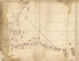
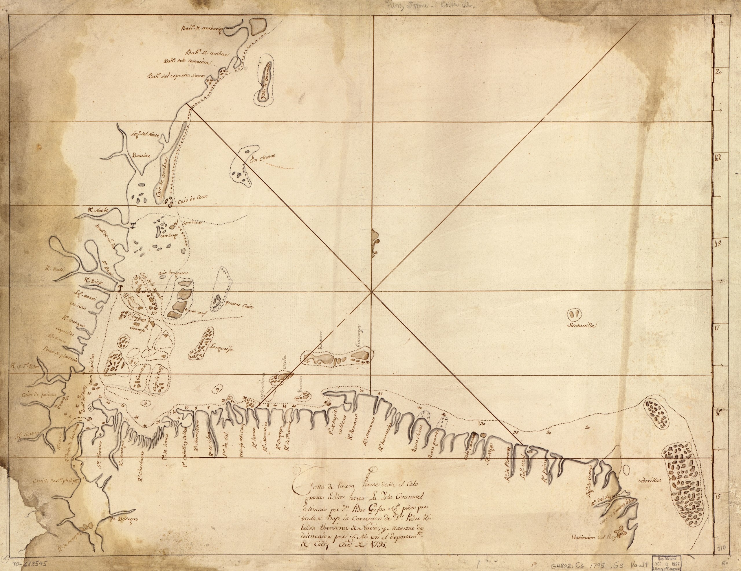
English: Shows Atlantic coast of Central America covering Belize, Guatemala, Honduras, a small portion of Nicaragua, and a portion of the Yucatán Peninsula. Depths shown by soundings. Watermark: PVL [Pieter van Ley] in 1 character. Pen-and-ink and brown ink. Mounted on cloth backing. LC Luso-Hispanic World, 59 Available also through the Library of Congress Web site as a raster image. Maggs number annotated in pencil in lower right corner: 310. Vault |
||
| Title | Costa de tierra firme desde el Cabo Gracias a Dios hasta la Ysla Cosumuel | ||
| Shelf ID | G4802.C6 1795 .G3 | ||
| Date | |||
| Source | https://www.loc.gov/item/90683545/ | ||
| Author | Gafas, Pedro | ||
| Permission (Reusing this file) |
|
||
| Other versions |
|
||
| Location | Atlantic Coast · Central America · Yucatán Peninsula | ||
| Part of | American Memory · Catalog · Geography And Map Division · Cultural Landscapes | ||
| Subject | Maps, Manuscript · Central America · Coasts · Atlantic Coast (Central America) · Maps · Early Works To 1800 · Yucatán Peninsula · Atlantic Coast · Manuscript Maps |


Licensing
[edit]|
This is a faithful photographic reproduction of a two-dimensional, public domain work of art. The work of art itself is in the public domain for the following reason:
The official position taken by the Wikimedia Foundation is that "faithful reproductions of two-dimensional public domain works of art are public domain".
This photographic reproduction is therefore also considered to be in the public domain in the United States. In other jurisdictions, re-use of this content may be restricted; see Reuse of PD-Art photographs for details. | ||||
File history
Click on a date/time to view the file as it appeared at that time.
| Date/Time | Thumbnail | Dimensions | User | Comment | |
|---|---|---|---|---|---|
| current | 10:05, 20 May 2018 |  | 7,626 × 5,876 (128.2 MB) | Fæ (talk | contribs) | LOC Maps https://www.loc.gov/item/90683545/ #12220 |
You cannot overwrite this file.
File usage on Commons
The following page uses this file: