File:Central Asian trade routes.jpg
Jump to navigation
Jump to search
Size of this preview: 800 × 565 pixels. Other resolutions: 320 × 226 pixels | 640 × 452 pixels | 954 × 674 pixels.
Original file (954 × 674 pixels, file size: 206 KB, MIME type: image/jpeg)
Captions
Captions
Add a one-line explanation of what this file represents
Summary
[edit]| Description |
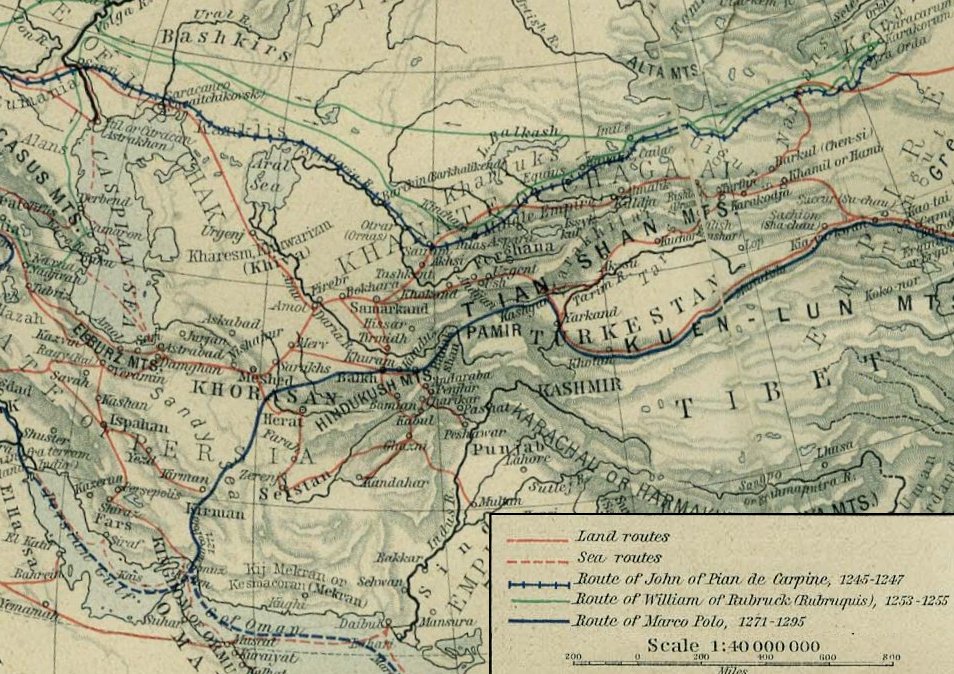
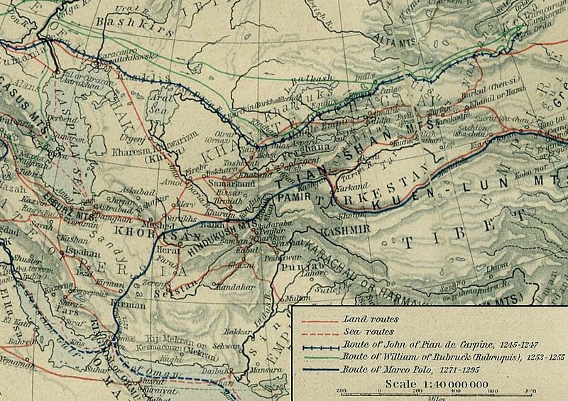
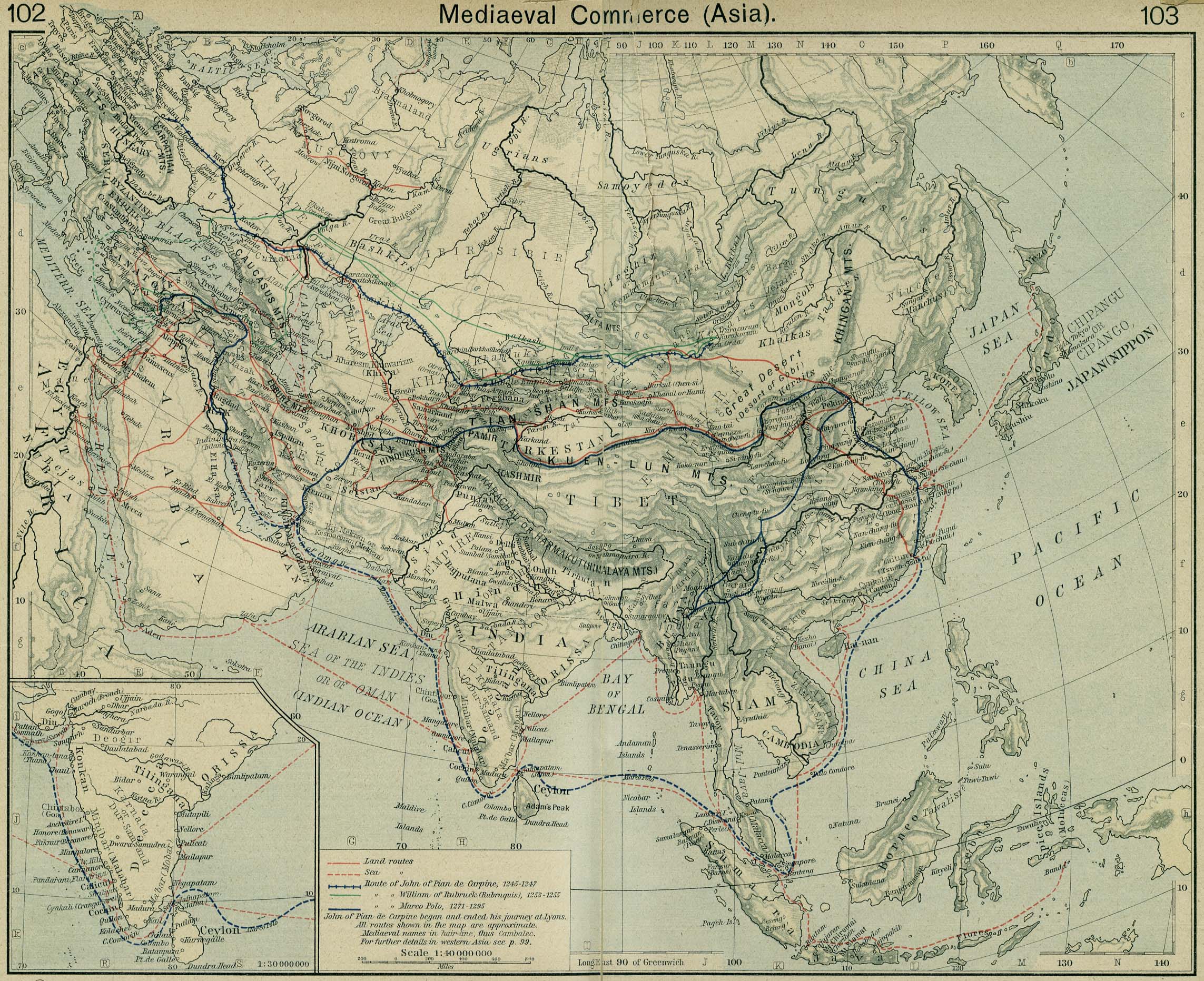
English: Mediaeval trade routes in central Asia. Modified map based on Sheherd Mediaeval Commerce (1923/first edition 1911)
Čeština: Středověké obchodní cesty ve střední Asii. Upravená mapa na základě "Historického atlasu" W. R. Shepherda, 1923 |
|||||||||||||||||||||||
| Source |
From the "Historical Atlas" by William R. Shepherd, New York, Henry Holt and Company, 1923 (2nd edition) |
|||||||||||||||||||||||
| Author |
|
|||||||||||||||||||||||
.png)
Licensing
[edit]
|
This work is in the public domain in its country of origin and other countries and areas where the copyright term is the author's life plus 70 years or fewer. | |
| This file has been identified as being free of known restrictions under copyright law, including all related and neighboring rights. | |
| Annotations | This image is annotated: View the annotations at Commons |
File history
Click on a date/time to view the file as it appeared at that time.
| Date/Time | Thumbnail | Dimensions | User | Comment | |
|---|---|---|---|---|---|
| current | 23:25, 27 May 2006 | | 954 × 674 (206 KB) | Ignacio Icke (talk | contribs) | Modified version of a 1926 public domain map from [http://www.lib.utexas.edu/maps/historical/shepherd/asia_mediaeval_commerce.jpg]. from en:Image:Central Asian trade routes.jpg Category:Central Asia Category:Trade Routes |
You cannot overwrite this file.
File usage on Commons
The following 8 pages use this file:
- Emergence
- File:Giovanni da Pian del Carpine - Opera dilettevole da intendere, nella qual si contiene doi itinerarij in Tartaria..., 1537(2) (page 1 crop).jpg
- File:Giovanni da Pian del Carpine - Opera dilettevole da intendere, nella qual si contiene doi itinerarij in Tartaria..., 1537.djvu
- File:Giovanni da Pian del Carpine - Opera dilettevole da intendere, nella qual si contiene doi itinerarij in Tartaria..., 1537 (page 11 crop).jpg
- File:Giovanni da Pian del Carpine - Opera dilettevole da intendere, nella qual si contiene doi itinerarij in Tartaria..., 1537 (page 1 crop).jpg
- File:Giovanni da Pian del Carpine - Opera dilettevole da intendere, nella qual si contiene doi itinerarij in Tartaria..., 1537 (page 3 crop).jpg
- Category:Giovanni da Pian del Carpine
- Creator:Giovanni da Pian del Carpine
_(page_1_crop).jpg)
.jpg)
.jpg)
.jpg)
File usage on other wikis
The following other wikis use this file:
- Usage on als.wikipedia.org
- Usage on ar.wikipedia.org
- Usage on arz.wikipedia.org
- Usage on avk.wikipedia.org
- Usage on az.wikipedia.org
- Usage on ba.wikipedia.org
- Usage on be.wikipedia.org
- Usage on bg.wikipedia.org
- Usage on ca.wikipedia.org
- Usage on cs.wikipedia.org
- Usage on da.wikipedia.org
- Usage on de.wikipedia.org
- Usage on en.wikipedia.org
- Usage on en.wikisource.org
- Usage on eo.wikipedia.org
- Usage on es.wikipedia.org
- Usage on es.wikisource.org
- Usage on eu.wikipedia.org
- Usage on fa.wikipedia.org
- Usage on fi.wikipedia.org
- Usage on fr.wikipedia.org
- Usage on he.wikipedia.org
- Usage on hy.wikipedia.org
- Usage on id.wikipedia.org
- Usage on it.wikipedia.org
- Usage on it.wikiquote.org
- Usage on it.wikisource.org
- Usage on ja.wikipedia.org
- Usage on ka.wikipedia.org
- Usage on kk.wikipedia.org
- Usage on ko.wikipedia.org
View more global usage of this file.
Metadata
Categories:
- Maps of the Silk Road
- Old maps of Xinjiang
- Maps of trade routes
- Maps showing history by William R. Shepherd
- Maps of Marco Polo's travels
- Wilhelm von Rubruk
- Johannes de Plano Carpini
- Qinghai Lake
- Maps of the Kunlun Mountains
- Maps of Lhasa
- East Turkestan
- Maps of 13th-century Asia
- Maps of Tibet
- Maps of Khiva
- Maps of the Brahmaputra
- Maps of the Indus River
- Maps of Tibetan Plateau
- History of Kashmir
- Maps of Lake Baikal
- Maps of Aral Sea
- Old maps of the Caspian Sea