File:BockerterHeide1844(PreußischeUraufnahme).jpg
Jump to navigation
Jump to search

Size of this preview: 800 × 450 pixels. Other resolutions: 320 × 180 pixels | 640 × 360 pixels | 1,264 × 711 pixels.
Original file (1,264 × 711 pixels, file size: 1.27 MB, MIME type: image/jpeg)
Captions
Captions
Add a one-line explanation of what this file represents
Summary
[edit].jpg&action=edit§ion=1)
| Description |
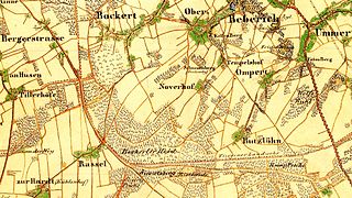
Deutsch: Topografische Karte 1:25000, Preußische Uraufnahme, Blatt 4704 (Viersen), Ausschnitt mit der Bockerter Heide und ihrer Umgebung.
English: Topographic Map 1:25000 by Royal Prussian Land Survey, sheet 4704 (Viersen), snippet displaying Bockert Heath and vicinity.
Nederlands: Topografische kaart 1:25000, Pruisische Oeropname, blad 4704 (Viersen), uittreksel met Bockertse Heide en omgeving. |
| Date | |
| Source | Selbst abgescannt: Vorlage war ein vom Landesvermessungsamt NRW (heute: Geobasisdaten Land NRW), Bonn 1991 herausgegebener Nachdruck. |
| Author | von Tempelhof, Prem. Lt. im 28ten Inf. Rgmt. |
Licensing
[edit].jpg&action=edit§ion=2)
|
This work is in the public domain in its country of origin and other countries and areas where the copyright term is the author's life plus 70 years or fewer. | |
| This file has been identified as being free of known restrictions under copyright law, including all related and neighboring rights. | |
File history
Click on a date/time to view the file as it appeared at that time.
| Date/Time | Thumbnail | Dimensions | User | Comment | |
|---|---|---|---|---|---|
| current | 17:38, 25 November 2011 | | 1,264 × 711 (1.27 MB) | Þomas (talk | contribs) | {{Information |Description ={{de|1=Topografische Karte 1:25000, Preußische Uraufnahme, Blatt 4704 (Viersen), Ausschnitt mit der ''Bockerter Heide'' und ihrer Umgebung.}} {{en|1=Topographic Map 1:25000 by Royal Prussian Land Survey, sheet 4704 (Viersen |
You cannot overwrite this file.
File usage on Commons
There are no pages that use this file.
File usage on other wikis
The following other wikis use this file:
.jpg&oldid=827415034)