File:Angel cartouche on a Mediterranean map by de Wit.tiff

Original file (1,229 × 1,039 pixels, file size: 3.65 MB, MIME type: image/tiff)
Captions
Captions
Summary
[edit]| Author |
De Wit; Wit, Frederik de |
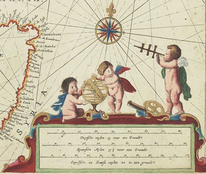
| Description |
English: Pas caart van de Middelandsche ZeeBound sheet. Hand col. engr. Scale: [ca. 1: (bar)]. Cartographic Note: Graduated for latitude only. Bar scales in Dutch miles, Spanish miles and English and French miles. Additional Places: Mediterranean. Contents Note: Cartouche decoration includes navigational instruments - chart, cross staff, astrolabe, and sphere.
In an atlas of twelve charts, seven by Frederik de Wit and five by Theunis Jacobz. |
| Date | 1654 |
| Dimensions | Printed area 44 x 54cm, on sheet 50.5 x 59cm. |
| Source/Photographer | http://collections.rmg.co.uk/collections/objects/542732 |
| Permission (Reusing this file) |
The original artefact or artwork has been assessed as public domain by age, and faithful reproductions of the two dimensional work are also public domain. No permission is required for reuse for any purpose. The text of this image record has been derived from the Royal Museums Greenwich catalogue and image metadata. Individual data and facts such as date, author and title are not copyrightable, but reuse of longer descriptive text from the catalogue may not be considered fair use. Reuse of the text must be attributed to the "National Maritime Museum, Greenwich, London" and a Creative Commons CC-BY-NC-SA-3.0 license may apply if not rewritten. Refer to Royal Museums Greenwich copyright. |
| Other versions | |
| Identifier | id number: PBD8044(7) |
| Collection | Charts and maps |

Licensing
[edit]|
This is a faithful photographic reproduction of a two-dimensional, public domain work of art. The work of art itself is in the public domain for the following reason:
The official position taken by the Wikimedia Foundation is that "faithful reproductions of two-dimensional public domain works of art are public domain".
This photographic reproduction is therefore also considered to be in the public domain in the United States. In other jurisdictions, re-use of this content may be restricted; see Reuse of PD-Art photographs for details. | ||||
File history
Click on a date/time to view the file as it appeared at that time.
| Date/Time | Thumbnail | Dimensions | User | Comment | |
|---|---|---|---|---|---|
| current | 00:11, 3 December 2022 |  | 1,229 × 1,039 (3.65 MB) | Enyavar (talk | contribs) | File:Eastern Sheet - Pas caart van de Middelandsche Zee RMG F8111 (cropped).tiff cropped 71 % horizontally, 41 % vertically using CropTool with precise mode. |
You cannot overwrite this file.
File usage on Commons
The following 2 pages use this file: