File:A map of the world with ships DUKE & DUTCHESS' tract round it from 1708 to 1711, by Herman Moll, geographer LCCN2007677057.jpg

A_map_of_the_world_with_ships_DUKE_&_DUTCHESS'_tract_round_it_from_1708_to_1711,_by_Herman_Moll,_geographer_LCCN2007677057.jpg (640 × 388 pixels, file size: 92 KB, MIME type: image/jpeg)
Captions
Captions
Summary
[edit]| Description |
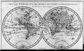
English: Title: A Map of the World with Ships DUKE & DUTCHES'S Tract Round It from 1708 to 1711
|
||
| Date | |||
| Source |
Library of Congress copy of A Cruising Voyage Round the World, frontispiece opposite title page
Main URL |
||
| Author |
Herman Moll, cartographer Emanuel Bowen, engraver Woodes Rogers, author |
||
| Permission (Reusing this file) |
|
||
| Other versions |
|
||
| Part of | rare book and special collections division · prints and photographs division |

Licensing
[edit]
|
This work is in the public domain in its country of origin and other countries and areas where the copyright term is the author's life plus 100 years or fewer. This work is in the public domain in the United States because it was published (or registered with the U.S. Copyright Office) before January 1, 1929. | |
| This file has been identified as being free of known restrictions under copyright law, including all related and neighboring rights. | |
| Annotations | This image is annotated: View the annotations at Commons |
File history
Click on a date/time to view the file as it appeared at that time.
| Date/Time | Thumbnail | Dimensions | User | Comment | |
|---|---|---|---|---|---|
| current | 15:21, 24 March 2018 | | 640 × 388 (92 KB) | Fæ (talk | contribs) | Library of Congress Miscellaneous Items in High Demand, PPOC, Library of Congress 1726 LCCN 2007677057 jpg # 17,697 / 48,929 |
You cannot overwrite this file.
File usage on Commons
The following page uses this file:
Metadata
- 1720s maps of the world
- 18th-century double hemisphere world maps
- Maps by Herman Moll
- Island of California on world maps
- Maps of voyages
- 1726 maps
- Maps connecting Australia and New Guinea
- Maps of the world without Antarctica
- Van Diemen's Land
- Company Land
- A Cruising Voyage Round the World
- Woodes Rogers
- Maps by Emanuel Bowen