File:2017 tornado paths in the United States.png
Jump to navigation
Jump to search

Size of this preview: 800 × 566 pixels. Other resolutions: 320 × 226 pixels | 640 × 452 pixels | 1,024 × 724 pixels | 1,280 × 905 pixels | 2,560 × 1,810 pixels | 4,700 × 3,323 pixels.
Original file (4,700 × 3,323 pixels, file size: 4.08 MB, MIME type: image/png)
Captions
Captions
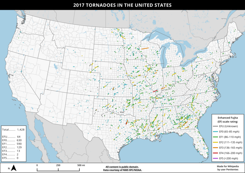
A map of confirmed tornado paths in 2017 in the contiguous United States, using NWS SPC/NOAA data.
Summary
[edit]
| Description |
English: This image shows the paths of the 1,400+ tornadoes that occurred in the contiguous United States in 2017, colored by their rating on the Enhanced Fujita (EF) scale. This image was made in QGIS using data from Natural Earth and NWS SPC/NOAA. |
| Date | |
| Source | Own work |
| Author | Penitentes |
Licensing
[edit]
I, the copyright holder of this work, hereby publish it under the following license:
This file is licensed under the Creative Commons Attribution-Share Alike 4.0 International license.
- You are free:
- to share – to copy, distribute and transmit the work
- to remix – to adapt the work
- Under the following conditions:
- attribution – You must give appropriate credit, provide a link to the license, and indicate if changes were made. You may do so in any reasonable manner, but not in any way that suggests the licensor endorses you or your use.
- share alike – If you remix, transform, or build upon the material, you must distribute your contributions under the same or compatible license as the original.
File history
Click on a date/time to view the file as it appeared at that time.
| Date/Time | Thumbnail | Dimensions | User | Comment | |
|---|---|---|---|---|---|
| current | 17:56, 15 June 2024 | | 4,700 × 3,323 (4.08 MB) | Penitentes (talk | contribs) | improved legend symbology + tornado visibility by magnitude |
| 03:13, 12 June 2024 |  | 4,700 × 3,323 (4.08 MB) | Penitentes (talk | contribs) | Uploaded own work with UploadWizard |
You cannot overwrite this file.
File usage on Commons
There are no pages that use this file.
File usage on other wikis
The following other wikis use this file:
- Usage on en.wikipedia.org