Category:Maps of weather and climate of the United States
Jump to navigation
Jump to search
Countries of the Americas: Argentina · The Bahamas · Bolivia · Brazil · Canada · Chile · Colombia · Costa Rica · Cuba · Dominican Republic · Ecuador · El Salvador · Guatemala · Guyana · Haiti · Honduras · Jamaica · Mexico · Nicaragua · Panama · Paraguay · Peru · Suriname · United States of America · Uruguay · Venezuela
Subcategories
This category has the following 3 subcategories, out of 3 total.
C
W
Media in category "Maps of weather and climate of the United States"
The following 46 files are in this category, out of 46 total.
-
 104 of 'Eclectic Physical Geography' (11201886896).jpg 2,064 × 1,315; 675 KB
-

-
-

-

-
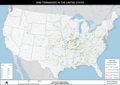
 2000 tornado paths in the United States.png 5,940 × 4,200; 4.67 MB
-
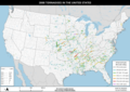
 2001 tornado paths in the United States.png 5,940 × 4,200; 4.73 MB
-
 2002 tornado paths in the United States.png 5,940 × 4,200; 4.65 MB
-
 2003 tornado paths in the United States.png 5,940 × 4,200; 4.79 MB
-
 2004 tornado paths in the United States.png 5,940 × 4,200; 4.85 MB
-
 2005 tornado paths in the United States.png 5,940 × 4,200; 4.76 MB
-
 2006 tornado paths in the United States.png 4,700 × 3,323; 3.83 MB
-
 2007 tornado paths in the United States.png 4,700 × 3,323; 3.73 MB
-
 2008 tornado paths in the United States.png 4,700 × 3,323; 4.16 MB
-
 2009 tornado paths in the United States.png 4,700 × 3,323; 3.95 MB
-
 2010 tornado paths in the United States.png 4,700 × 3,323; 4.02 MB
-
 2011 tornado paths in the United States.png 4,700 × 3,323; 4.18 MB
-
 2012 tornado paths in the United States.png 4,700 × 3,323; 3.91 MB
-
 2013 tornado paths in the United States.png 4,700 × 3,323; 3.9 MB
-
 2014 tornado paths in the United States.png 4,700 × 3,323; 3.9 MB
-
 2015 tornado paths in the United States.png 4,700 × 3,323; 4 MB
-
 2016 tornado paths in the United States.png 4,700 × 3,323; 3.92 MB
-
 2017 tornado paths in the United States.png 4,700 × 3,323; 4.08 MB
-
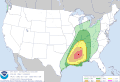 Day 1 1300 UTC Convective Outlook.gif 815 × 555; 28 KB
-
 Day11630UTCOlook.gif 815 × 555; 30 KB
-
 Day12000UTCOlook prt.gif 815 × 555; 31 KB
-
 Hurricane Laura rainfall.png 462 × 557; 159 KB
-
 January 12, 2023 Day 1 2000 UTC Outlook.gif 815 × 555; 25 KB
-
 March 1, 2023 1630 UTC Outlook.gif 815 × 555; 28 KB
-
 March 1, 2023 1730 UTC Day 2 Tornado Outlook.gif 815 × 555; 27 KB
-
 March 12, 2006 Day 1 1630 UTC Convective Outlook.gif 582 × 410; 19 KB
-
 March 12, 2006 Tornado probability contour.gif 582 × 410; 19 KB
-
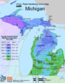 Michigan Hardiness Zone Map.webp 530 × 680; 45 KB
-
 NEFlooding2005 2.gif 920 × 800; 270 KB
-
 NEFlooding2006 7day Rainfall.gif 720 × 435; 75 KB
-
 NIE 1905 Storm - tracks of centres of low areas (January 1901).jpg 1,511 × 1,006; 441 KB
-
 Seasonal Snowfall 09-30-22 to 11-03-22.png 1,500 × 978; 179 KB
-
 Southwestheat geos5 20240606.jpg 720 × 700; 388 KB
-
 Subtropusa.PNG 800 × 552; 70 KB
-
 Typhoonsizes. ua.png 281 × 179; 51 KB
-
 Uscontinentalclimatemap.PNG 841 × 580; 29 KB
-
 Uscontinentalclimatemap1.PNG 841 × 580; 29 KB
-
 Ussubtropicalmap.PNG 841 × 580; 29 KB
-
 West Virginia-Kentucky Derecho.jpg 480 × 329; 32 KB
-

-
 Winds of the northern vis.png 568 × 760; 354 KB
.jpg)
.jpg)
.jpg)
_C._H._Hitchcock,_State_Geologist,_J._H._Huntington,_Principal_Assistant%27_(11106325514).jpg)
_C._H._Hitchcock,_State_Geologist,_J._H._Huntington,_Principal_Assistant%27_(11103799653).jpg)


.jpg)


