File:1799 Cary Map of the Netherlands - Geographicus - Netherlands-cary-1799.jpg
Jump to navigation
Jump to search

Size of this preview: 670 × 599 pixels. Other resolutions: 268 × 240 pixels | 537 × 480 pixels | 859 × 768 pixels | 1,145 × 1,024 pixels | 2,290 × 2,048 pixels | 5,000 × 4,472 pixels.
Original file (5,000 × 4,472 pixels, file size: 7.88 MB, MIME type: image/jpeg)
Captions
Captions
Add a one-line explanation of what this file represents
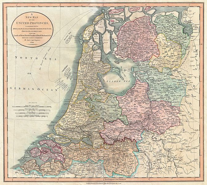
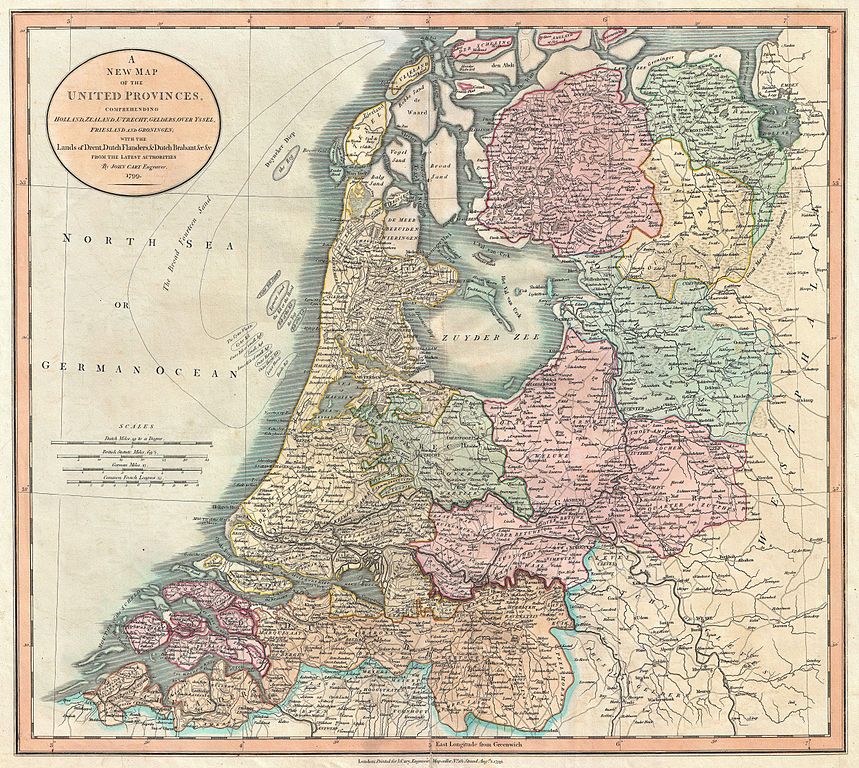
| John Cary: A New Map of the United Provinces, comprehending Holland, Zealand, Utrecht, Gelders, Over Yssel, Friesland and Groningen; with the Lands of Drent, Dutch Flanders, & Dutch Brabant &c &c from the Latest Authorities.
( |
||||||||||||||||||||||||||
|---|---|---|---|---|---|---|---|---|---|---|---|---|---|---|---|---|---|---|---|---|---|---|---|---|---|---|
| Artist |
|
|||||||||||||||||||||||||
| Title |
A New Map of the United Provinces, comprehending Holland, Zealand, Utrecht, Gelders, Over Yssel, Friesland and Groningen; with the Lands of Drent, Dutch Flanders, & Dutch Brabant &c &c from the Latest Authorities. |
|||||||||||||||||||||||||
| Description |
English: An extremely attractive example of John Cary’s 1799 map of the Netherlands. Consists of the provinces of Holland, Zealand, Utrecht, Gelders, Over Yssel, Friesland, and Groningen, as well as Drent, Dutch Flanders, and Dutch Brabant. Shows the massive “Broad Fourteen” sandbars in the North Sea. All in all, one of the most interesting and attractive atlas maps the Netherlands to appear in first years of the 19th century. Prepared in 1799 by John Cary for issue in his magnificent 1808 New Universal Atlas . |
|||||||||||||||||||||||||
| Date | 1799 (dated) | |||||||||||||||||||||||||
| Dimensions | height: 18.5 in (46.9 cm); width: 20.5 in (52 cm) | |||||||||||||||||||||||||
| Accession number |
Geographicus link: Netherlands-cary-1799 |
|||||||||||||||||||||||||
| Source/Photographer |
Cary, John, Cary's New Universal Atlas, containing distinct maps of all the principal states and kingdoms throughout the World. From the latest and best authorities extant. London: Printed for J. Cary, Engraver and Map-seller, No. 181, near Norfolk Street, Strand, 1808.
|
|||||||||||||||||||||||||
| Permission (Reusing this file) |
|
|||||||||||||||||||||||||
File history
Click on a date/time to view the file as it appeared at that time.
| Date/Time | Thumbnail | Dimensions | User | Comment | |
|---|---|---|---|---|---|
| current | 11:50, 22 March 2011 | | 5,000 × 4,472 (7.88 MB) | BotMultichillT (talk | contribs) | {{subst:User:Multichill/Geographicus |link=http://www.geographicus.com/P/AntiqueMap/Netherlands-cary-1799 |product_name=1799 Cary Map of the Netherlands |map_title=A New Map of the United Provinces, comprehending Holland, Zealand, Utrecht, Gelders, Over Y |
You cannot overwrite this file.
File usage on Commons
The following page uses this file: