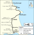
Category:Yorkshire Coast Line
Jump to navigation
Jump to search
railway line in northern England | |||||
| Upload media | |||||
| Instance of | |||||
|---|---|---|---|---|---|
| Location | Yorkshire and the Humber, England | ||||
| Owned by | |||||
| Date of official opening |
| ||||
| Length |
| ||||
| Terminus | |||||
| |||||
Subcategories
This category has the following 30 subcategories, out of 30 total.
A
- Arram railway station (18 F)
B
- Bempton railway station (23 F)
- Bridlington railway station (151 F)
C
- Carnaby railway station (7 F)
- Cayton railway station (4 F)
- Cottingham railway station (50 F)
D
- Driffield railway station (38 F)
F
- Filey railway station (36 F)
G
H
- Hunmanby railway station (27 F)
L
N
- Nafferton railway station (21 F)
R
S
- Speeton railway station (4 F)
Media in category "Yorkshire Coast Line"
The following 32 files are in this category, out of 32 total.
-
Autumn track IMG 7068.jpg - panoramio.jpg 1,600 × 1,046; 572 KB
-
Back on track (geograph 1981614).jpg 800 × 600; 161 KB
-
Bridlington to Hull line through Cottingham toward Hull - geograph.org.uk - 5757137.jpg 4,556 × 3,386; 4.87 MB
-
Footpath between field and railway (geograph 1999576).jpg 2,304 × 1,728; 1.63 MB
-
Level crossing on Skerne Road (geograph 4287548).jpg 640 × 438; 61 KB
-
Line to Driffield (geograph 6292252).jpg 1,024 × 768; 238 KB
-
Path leading to Black House Farm, Long Lane (geograph 5099921).jpg 1,600 × 1,065; 795 KB
-
Path leading to the A164 (geograph 6496558).jpg 5,456 × 3,632; 3.07 MB
-
Path leading to the A164 (geograph 6496565).jpg 5,228 × 3,468; 2.04 MB
-
Rail crossing at Priest Ings, Hutton Cranswick (geograph 5947956).jpg 1,600 × 1,064; 415 KB
-
Railway Embankment - geograph.org.uk - 1700387.jpg 800 × 600; 169 KB
-
Railway Embankment near Grindale Road - geograph.org.uk - 1208816.jpg 640 × 480; 109 KB
-
Railway line to Bridlington - geograph.org.uk - 3551508.jpg 4,530 × 3,350; 3.85 MB
-
Railway Line Towards Filey - geograph.org.uk - 1234804.jpg 640 × 480; 98 KB
-
Railway towards Beverley (geograph 5253589).jpg 640 × 480; 74 KB
-
Railway towards Bridlington - geograph.org.uk - 4493185.jpg 640 × 469; 63 KB
-
Railway towards Bridlington - geograph.org.uk - 4493228.jpg 640 × 460; 59 KB
-
Railway towards Driffield (geograph 5253587).jpg 640 × 480; 80 KB
-
Railway towards Driffield - geograph.org.uk - 1302144.jpg 640 × 480; 107 KB
-
Railway towards Hunmanby - geograph.org.uk - 1310421.jpg 640 × 480; 86 KB
-
Railway towards Nafferton Station - geograph.org.uk - 1302298.jpg 640 × 480; 118 KB
-
Railway towards Scarborough - geograph.org.uk - 4493190.jpg 640 × 458; 82 KB
-
The KC Stadium - geograph.org.uk - 606605.jpg 640 × 245; 45 KB
-
Too close for comfort? (geograph 1981633).jpg 800 × 600; 149 KB
-
What a mess (geograph 1981626).jpg 800 × 600; 169 KB
-
YCLmap.png 763 × 783; 135 KB
-
Yorkshire Coast Line - geograph.org.uk - 5396581.jpg 640 × 426; 80 KB
-
Yorkshire Coast Line - geograph.org.uk - 5396585.jpg 640 × 426; 63 KB


