Category:Wisconsin Highway 15
Jump to navigation
Jump to search
 | number: | (fifteen) |
|---|---|---|
| State highways in Wisconsin: | 11 · 12 · 13 · 14 · 15 · 16 · 17 · 19 · 20 · 21 · 22 · 23 · 24 · 25 · 26 · 27 · 28 · 29 · 30 · 31 · 32 · 33 · 34 · 35 |
state highway Outagamie County, Wisconsin, United States   | |||||
| Upload media | |||||
| Instance of | |||||
|---|---|---|---|---|---|
| Location | Outagamie County, Wisconsin | ||||
| Transport network | |||||
| Owned by | |||||
| Maintained by | |||||
| Length |
| ||||
| Terminus | |||||
| |||||
English: Media related to Wisconsin Highway 15, a 14.8-mile (23.8 km) state highway in Outagamie County, Wisconsin, United States.
Subcategories
This category has only the following subcategory.
Media in category "Wisconsin Highway 15"
The following 12 files are in this category, out of 12 total.
-
 Aerial Greenville.jpg 4,000 × 3,000; 5.11 MB
-
 GreenvilleWisconsin2WIS76.jpg 1,936 × 1,288; 792 KB
-
 GreenvilleWisconsinSignWIS15.jpg 1,756 × 1,164; 611 KB
-
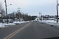
 Highway15WisconsinEastTerminus.jpg 2,304 × 1,728; 626 KB
-
 HortonvilleCommunityHallWIS15.jpg 1,936 × 1,288; 1.34 MB
-
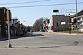 HortonvilleWisconsinDowntown1WIS15.jpg 1,936 × 1,288; 996 KB
-
 HortonvilleWisconsinDowntown2WIS15.jpg 1,936 × 1,288; 1,007 KB
-
 HortonvilleWisconsinSignWIS15.jpg 1,936 × 1,288; 853 KB
-
 WI15 East towards I-43 Aerial.jpg 3,600 × 2,400; 3.72 MB
-
 WIS 15.svg 384 × 384; 2 KB
-
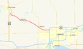 Wis-15-map.png 960 × 569; 86 KB
-
 Wisconsin Highway 15 West Terminus looking East.jpg 1,792 × 1,144; 699 KB


