Category:Utah State Route 64
Jump to navigation
Jump to search
 | number: | (sixty-four) |
|---|---|---|
| State highways in Utah: | 44 · 45 · 46 · 47 · 48 · 49 · 50 · 51 · 52 · 53 · 54 · 55 · 56 · 57 · 58 · 59 · 60 · 61 · 62 · 63 · 64 · 65 · 66 · 67 · 68 · 69 · 70 · 71 · 72 · 73 · 74 · 75 · 76 · 77 · 78 · 79 · 80 · 81 · 82 · 83 · 84 |
state highway in Millard County, Utah, United States | |||||
| Upload media | |||||
| Instance of | |||||
|---|---|---|---|---|---|
| Location | Millard County, Utah | ||||
| Transport network | |||||
| Owned by | |||||
| Maintained by | |||||
| Inception |
| ||||
| Length |
| ||||
| Terminus | |||||
 | |||||
English: Media related to Utah State Route 64 (SR-64), a 2.0229-mile (3.2555 km) state highway in the Pahvant Valley in eastern Millard County, Utah, United States, that connects Interstate 15 (south-southwest of Holden) with U.S. Route 50 (just north of Holden). SR-64 is part of the former Utah State Route 26.
Subcategories
This category has the following 2 subcategories, out of 2 total.
Media in category "Utah State Route 64"
The following 6 files are in this category, out of 6 total.
-
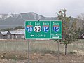 Interstates and US 50 directional sign in Holden, Utah.jpg 4,320 × 3,240; 5.45 MB
-
 Sr64 exit174 i 1492.jpg 4,032 × 3,024; 2.58 MB
-
 Us50 sr64 split i1488.jpg 4,032 × 3,024; 5.1 MB
-
 Us50 sr64 splitbgs i1484.jpg 4,032 × 3,024; 4.7 MB
-
 Utah 64.svg 600 × 600; 11 KB
-
 Utah SR 64.svg 385 × 385; 8 KB


