Category:Utah State Route 261
Jump to navigation
Jump to search
 | number: | (two hundred sixty-one) |
|---|---|---|
| State highways in Utah: | 241 · 243 · 247 · 248 · 252 · 256 · 257 · 258 · 259 · 260 · 261 · 262 · 263 · 264 · 265 · 266 · 268 · 269 · 270 · 271 · 273 · 274 · 275 · 276 · 279 · 280 · 281 |
state highway in San Juan County, Utah, United States  | |||||
| Upload media | |||||
| Instance of | |||||
|---|---|---|---|---|---|
| Location | San Juan County, Utah | ||||
| Transport network | |||||
| Owned by |
| ||||
| Maintained by |
| ||||
| Has part(s) | |||||
| Inception |
| ||||
| Length |
| ||||
| Terminus | |||||
| Partially coincident with | |||||
 | |||||
English: Media related to Utah State Route 261, a 32.6444-mile (52.5361 km) state highway in San Juan County, Utah, United States, that connects U.S. Route 163 (north of Mexican Hat) with Utah State Route 95 (east-southeast of the Natural Bridges National Monument) via Moki Dudway.
Subcategories
This category has the following 2 subcategories, out of 2 total.
M
Media in category "Utah State Route 261"
The following 11 files are in this category, out of 11 total.
-
 BearsEarsUSGS-2D.jpg 800 × 600; 425 KB
-
 BearsEarsUSGS.jpg 800 × 570; 493 KB
-
 Grand Staircase 201812 0193 (43703690222).jpg 3,264 × 2,448; 1.65 MB
-
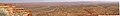 MokiDugwayPanoramaByPhilKonstantin.jpg 3,002 × 401; 139 KB
-
 The Road to Monument Valley, (Route 261 Utah) (3467673903).jpg 2,784 × 1,856; 1.02 MB
-
 UT261 southern terminus.jpg 2,912 × 4,368; 3.82 MB
-
 Utah 261.svg 750 × 600; 73 KB
-
 Utah SR 261.svg 385 × 385; 9 KB
-
 Utah State Route 261 as seen from the Moki Dugway.jpg 4,368 × 2,912; 3.96 MB
-
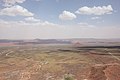 Valley of the Gods - panoramio (3).jpg 5,184 × 3,456; 6.5 MB
-
 Valley of the Gods road - panoramio.jpg 5,184 × 3,456; 8.71 MB


.jpg)
_(3467673903).jpg)


.jpg)
