Category:United Kingdom photographs taken on 2007-03-21
Jump to navigation
Jump to search
| ← | Wednesday 21 March 2007 | → | ||
| ← | March 2007 | → | ||

United Kingdom photographs taken on 21 March 2007.
Image files should be categorized here automatically using {{taken on}} template. Direct categorisation is also possible, if automatic is impossible.
Subcategories
This category has only the following subcategory.
S
Media in category "United Kingdom photographs taken on 2007-03-21"
The following 200 files are in this category, out of 1,031 total.
(previous page) (next page)-
 'Beach' and headland - geograph.org.uk - 386280.jpg 640 × 480; 54 KB
-
 'Golau Penmon ' - Trwyn Du Lighthouse - geograph.org.uk - 377432.jpg 640 × 480; 52 KB
-
 275 KC-707 Reem 120 Sqdn IDFAF (2999883530).jpg 2,838 × 1,900; 480 KB
-
 47813 & 47810 New Tupton (3566591159).jpg 1,024 × 734; 432 KB
-
 A footbridge on the Coed yr Hendy path - geograph.org.uk - 375003.jpg 640 × 480; 150 KB
-
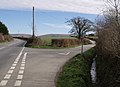
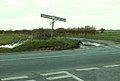 A junction on the A.1141 - geograph.org.uk - 374123.jpg 640 × 433; 48 KB
-
 A long portage - geograph.org.uk - 642229.jpg 640 × 360; 78 KB
-

-
 A tree-sheltered field at Marian - geograph.org.uk - 374722.jpg 640 × 480; 64 KB
-

-
 AandE Department, Ysbyty Gwynedd - geograph.org.uk - 373150.jpg 640 × 462; 70 KB
-
 Acland Hood Arms Hotel - geograph.org.uk - 878173.jpg 640 × 428; 65 KB
-
 Across The Bridleway To North Wood - geograph.org.uk - 373254.jpg 640 × 480; 96 KB
-
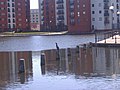
 Aire Street - geograph.org.uk - 372677.jpg 640 × 480; 98 KB
-
 Albion Street - geograph.org.uk - 372658.jpg 640 × 480; 93 KB
-
 Aldi Supermarket - geograph.org.uk - 373129.jpg 640 × 480; 70 KB
-
 All Saints' Church, Hightown - geograph.org.uk - 372629.jpg 640 × 475; 77 KB
-
 Allinson's mill on the River Aire - geograph.org.uk - 372672.jpg 640 × 474; 76 KB
-
 Allinsons Flour Mill - geograph.org.uk - 372669.jpg 640 × 480; 70 KB
-
 Allotments at Hatfield - geograph.org.uk - 432291.jpg 640 × 465; 81 KB
-
 Altar Lane, St. Ives Estate - geograph.org.uk - 375231.jpg 640 × 477; 146 KB
-
 Altar Window at Kings Caple Church - geograph.org.uk - 462202.jpg 480 × 640; 152 KB
-
 An alpaca at Broomilees Farm - geograph.org.uk - 373167.jpg 640 × 480; 115 KB
-
 Animal feeder, near Wick. - geograph.org.uk - 375619.jpg 640 × 456; 127 KB
-

-
 Approaching Sargill Beck - geograph.org.uk - 373006.jpg 640 × 480; 111 KB
-

-

-
 Arinabea in Glen Lochy - geograph.org.uk - 373138.jpg 640 × 480; 107 KB
-
 Ascending Shutt Lane - geograph.org.uk - 372985.jpg 640 × 480; 95 KB
-

-
 Atlantic Wharf - geograph.org.uk - 410425.jpg 640 × 480; 87 KB
-
 B4265 St.Athan, Vale of Glamorgan - geograph.org.uk - 373874.jpg 640 × 480; 69 KB
-
 Bank Street - geograph.org.uk - 372849.jpg 640 × 473; 86 KB
-
 Barges on the Canal - geograph.org.uk - 372806.jpg 640 × 480; 75 KB
-
 Baxter's Pond - geograph.org.uk - 376177.jpg 460 × 640; 157 KB
-
 Beckfoot Lane - geograph.org.uk - 375069.jpg 640 × 467; 142 KB
-
 Bedlam Lane, Staveley. - geograph.org.uk - 372819.jpg 640 × 480; 136 KB
-

-
 Betty's Lodge, St. Ives Estate - geograph.org.uk - 375200.jpg 640 × 480; 149 KB
-
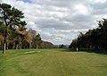 Bingley St. Ives Golf Course - geograph.org.uk - 375275.jpg 640 × 451; 81 KB
-
 Binsdale Farm - geograph.org.uk - 373265.jpg 640 × 480; 95 KB
-
 Birdingbury Wharf - geograph.org.uk - 377070.jpg 640 × 480; 145 KB
-
 Black Bank Hags - geograph.org.uk - 373054.jpg 640 × 480; 83 KB
-
 Black Heath Pond - geograph.org.uk - 373087.jpg 640 × 480; 146 KB
-
 Blackbroom - geograph.org.uk - 373926.jpg 640 × 443; 95 KB
-
 Bolberry Down cliff car park - geograph.org.uk - 373019.jpg 640 × 480; 150 KB
-
 Boundary Wall - geograph.org.uk - 374775.jpg 640 × 480; 99 KB
-

-
 Bradley Viaduct, Bradley - Kirkheaton - geograph.org.uk - 376039.jpg 640 × 480; 123 KB
-
 Bratton Clovelly Bridleway 6 - geograph.org.uk - 373859.jpg 640 × 480; 151 KB
-
 Bratton Clovelly Bridleway 6 - geograph.org.uk - 380563.jpg 640 × 480; 159 KB
-
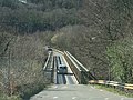
 Bridge House - geograph.org.uk - 372823.jpg 640 × 472; 74 KB
-
 Bridge in Kingskerswell - geograph.org.uk - 376172.jpg 640 × 480; 130 KB
-
 Bridge No. 1 Coventry Canal - geograph.org.uk - 372856.jpg 640 × 468; 97 KB
-
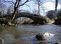
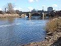 Bridge over the River Aire - geograph.org.uk - 372675.jpg 640 × 480; 94 KB
-
-
 Bridge Street - geograph.org.uk - 372828.jpg 640 × 476; 70 KB
-
 Bridleway - geograph.org.uk - 372733.jpg 640 × 481; 86 KB
-
 Bridleway - geograph.org.uk - 373231.jpg 640 × 480; 127 KB
-
 Bridleway From The B1253 - geograph.org.uk - 373243.jpg 640 × 480; 87 KB
-
 Bridleway near North Lees - geograph.org.uk - 373078.jpg 480 × 640; 136 KB
-
 Bridleway to Mackershaw - geograph.org.uk - 372869.jpg 640 × 480; 111 KB
-
 Bridleway Towards North Wood - geograph.org.uk - 373247.jpg 640 × 480; 93 KB
-
 Bridleway, close to Arger Fen - geograph.org.uk - 373976.jpg 640 × 480; 109 KB
-
 Broad Street Basin, BCN, Wolverhampton - geograph.org.uk - 373104.jpg 1,440 × 985; 1.55 MB
-
 Bronze Bull Cranborne Manor - geograph.org.uk - 373153.jpg 640 × 427; 150 KB
-
 Burberry Factory - geograph.org.uk - 372654.jpg 640 × 480; 89 KB
-
 Burnham Green Lane, Syderstone - geograph.org.uk - 373415.jpg 640 × 480; 92 KB
-
 Bwi Carreg Edwen-Perch Rock Buoy - geograph.org.uk - 375418.jpg 640 × 480; 47 KB
-

-
 Carlsberg Depot, Durham - geograph.org.uk - 373387.jpg 640 × 480; 57 KB
-
 Carlton Lanes Shopping Centre - geograph.org.uk - 372835.jpg 640 × 475; 67 KB
-
 Carlton Lanes Shopping Centre - geograph.org.uk - 372840.jpg 473 × 640; 80 KB
-
 Carlton Lanes Shopping Centre - geograph.org.uk - 372858.jpg 640 × 480; 82 KB
-
 Carlton Street - geograph.org.uk - 372854.jpg 640 × 480; 88 KB
-
 Carreg yr Imbill - Gimlet Rock Pwllheli.jpg 640 × 428; 135 KB
-
 Cascade, Pool and Oceanides - geograph.org.uk - 373903.jpg 640 × 527; 91 KB
-
 Castle Dike - geograph.org.uk - 372951.jpg 640 × 427; 64 KB
-
 Castle Dike - geograph.org.uk - 372953.jpg 640 × 427; 56 KB
-

-
 Castlefield Canal Basin - geograph.org.uk - 372778.jpg 640 × 427; 102 KB
-
 Castleford Bus Station - geograph.org.uk - 372661.jpg 640 × 480; 83 KB
-
 Castleford Gates Signal Box - geograph.org.uk - 372643.jpg 640 × 475; 83 KB
-
 Castleford Level Crossing - geograph.org.uk - 372651.jpg 640 × 474; 75 KB
-
 Castleford Railway Station - geograph.org.uk - 373018.jpg 640 × 476; 84 KB
-
 Castleford Station Signal Box - geograph.org.uk - 373011.jpg 640 × 569; 82 KB
-
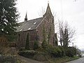
 Catholic Church, Maidstone - geograph.org.uk - 383041.jpg 640 × 479; 83 KB
-
 Cemetery - geograph.org.uk - 374896.jpg 640 × 387; 67 KB
-
 Chestermoor - geograph.org.uk - 373837.jpg 640 × 480; 126 KB
-
 Chestermoor Cross - geograph.org.uk - 379595.jpg 640 × 465; 87 KB
-
 Church of St. Mary, Charlynch. - geograph.org.uk - 878203.jpg 640 × 428; 80 KB
-
 Churchyard - geograph.org.uk - 378994.jpg 640 × 360; 114 KB
-
 Chwarel Parc Dinmor Park Quarry - geograph.org.uk - 375447.jpg 640 × 330; 50 KB
-
 Claypit Lane, Roecliffe - geograph.org.uk - 372803.jpg 640 × 480; 67 KB
-
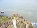
 Cliff at Bolberry Down, Bolberry - geograph.org.uk - 373008.jpg 640 × 480; 144 KB
-

-
 Clifftop farmland at Cerrig Duon - geograph.org.uk - 373244.jpg 640 × 322; 49 KB
-
 Coleridge cottage.jpg 640 × 428; 47 KB
-

-
 Copse near Copgrove - geograph.org.uk - 372838.jpg 640 × 480; 86 KB
-
 Cottage at Hurst - geograph.org.uk - 374405.jpg 640 × 480; 154 KB
-
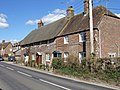
 Cottages at East Knapton - geograph.org.uk - 372982.jpg 640 × 480; 123 KB
-
 Cottages at Warmwell - geograph.org.uk - 374461.jpg 640 × 480; 133 KB
-
 Cottingley Bridge Allotment Garden - geograph.org.uk - 375062.jpg 640 × 471; 116 KB
-
 County Hall, Maidstone - geograph.org.uk - 383037.jpg 640 × 479; 93 KB
-
 Coventry Bishop Street canal basin - geograph.org.uk - 372801.jpg 640 × 480; 96 KB
-
 Coventry Canal warehouse - geograph.org.uk - 373268.jpg 472 × 640; 93 KB
-
 Cranborne Manor from East - geograph.org.uk - 373164.jpg 503 × 640; 137 KB
-
 Cranborne Manor through avenue of Beech - geograph.org.uk - 373147.jpg 640 × 427; 140 KB
-
 Creake Road, Syderstone - geograph.org.uk - 373402.jpg 640 × 480; 83 KB
-
 Croes-Cwtta, Valeof Glamorgan. - geograph.org.uk - 375589.jpg 640 × 461; 85 KB
-
 Cromer Pier - geograph.org.uk - 896203.jpg 640 × 426; 57 KB
-
 Crossways Post Office and General Stores - geograph.org.uk - 374421.jpg 640 × 480; 139 KB
-

-
 Crossways Retail Park, Caerphilly - geograph.org.uk - 372628.jpg 640 × 480; 68 KB
-
 Crossways Retail Park, Caerphilly - geograph.org.uk - 372635.jpg 640 × 480; 100 KB
-
 Crown Inn - geograph.org.uk - 374194.jpg 640 × 480; 90 KB
-
 Culverhouse Cross Link road.jpg 551 × 435; 61 KB
-
 Cyclamen at Cranborne Manor - geograph.org.uk - 373177.jpg 640 × 427; 131 KB
-
 Cyclamen at Cranborne Manor - geograph.org.uk - 374036.jpg 640 × 427; 139 KB
-
 Cycleway junction, Bradley, Huddersfield - geograph.org.uk - 381590.jpg 640 × 480; 124 KB
-
 Cyfarthfa Castle, Merthyr Tydfil - geograph.org.uk - 1057882.jpg 640 × 480; 103 KB
-
 Daffodil picking - geograph.org.uk - 372906.jpg 640 × 427; 63 KB
-
 Daffodils at High Hill farm - geograph.org.uk - 372873.jpg 640 × 427; 92 KB
-
 Dead Edge Flat - geograph.org.uk - 372726.jpg 640 × 480; 84 KB
-
 Dead Edge Flat - geograph.org.uk - 374136.jpg 640 × 480; 119 KB
-
 Dead Edge Flat - geograph.org.uk - 374344.jpg 640 × 480; 110 KB
-
 Dearden Clough - geograph.org.uk - 372673.jpg 640 × 480; 122 KB
-
 Dethick - Manor Farm viewed from Road - geograph.org.uk - 373394.jpg 640 × 480; 87 KB
-

-
 Dinmor Quarry - geograph.org.uk - 376041.jpg 640 × 408; 71 KB
-
 Disused railway track. - geograph.org.uk - 373378.jpg 640 × 427; 87 KB
-
 Dittisham - geograph.org.uk - 885407.jpg 480 × 640; 357 KB
-
 Dobcross from a distance.jpg 451 × 327; 169 KB
-
 Dogs beware - geograph.org.uk - 380609.jpg 480 × 640; 52 KB
-
 Dotland - geograph.org.uk - 373109.jpg 600 × 450; 133 KB
-
 Downhill to the dovecote - geograph.org.uk - 373893.jpg 640 × 480; 140 KB
-
 Driveway to Ings Farm on Yedingham Ings - geograph.org.uk - 372898.jpg 640 × 480; 145 KB
-
 Drystone wall near Ballymartin - geograph.org.uk - 372903.jpg 640 × 426; 147 KB
-
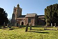
 St.Peter's church, Dunston - geograph.org.uk - 373041.jpg 640 × 427; 70 KB
-
 The Old School, Dunston - geograph.org.uk - 373005.jpg 640 × 427; 56 KB
-
 Durleigh Church.jpg 640 × 428; 72 KB
-
 Dyffryn Village, near Cardiff. - geograph.org.uk - 373488.jpg 640 × 480; 112 KB
-
 Ebony Pumping Station - geograph.org.uk - 388588.jpg 640 × 480; 97 KB
-
 Elephants at Cranborne Manor - geograph.org.uk - 373184.jpg 427 × 640; 126 KB
-
 Entering Crickhowell - geograph.org.uk - 373287.jpg 640 × 480; 140 KB
-
 Enterprise Way Retail Park - geograph.org.uk - 373038.jpg 640 × 474; 74 KB
-

-
 Entrance to Tiger Hill Wood - geograph.org.uk - 373955.jpg 640 × 480; 109 KB
-
 Entrance to Woodcock Delph - geograph.org.uk - 373042.jpg 640 × 480; 106 KB
-
 Fairfield Fishery Track - geograph.org.uk - 372860.jpg 640 × 480; 125 KB
-
 Fallen trees in a wood - geograph.org.uk - 380590.jpg 480 × 640; 146 KB
-
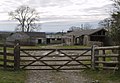
 Farm building - geograph.org.uk - 374843.jpg 640 × 424; 53 KB
-
 Farm buildings - geograph.org.uk - 374125.jpg 640 × 465; 68 KB
-
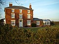
 Farmhouse at Hurrell's Farm - geograph.org.uk - 374090.jpg 640 × 480; 70 KB
-
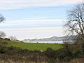 Farmland below Penmon Priory - geograph.org.uk - 377572.jpg 640 × 480; 79 KB
-
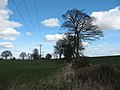 Farmland near Bishop Monkton - geograph.org.uk - 372843.jpg 640 × 480; 85 KB
-
 Farmland SE Of Wold Newton - geograph.org.uk - 373211.jpg 640 × 480; 109 KB
-
 Festri Penlan Vestry - geograph.org.uk - 372630.jpg 640 × 428; 126 KB
-
 Field and wood near Ashbury - geograph.org.uk - 374121.jpg 640 × 426; 87 KB
-
 Field track and plantation - geograph.org.uk - 374862.jpg 640 × 424; 60 KB
-

-
 Fishtoft Drove - geograph.org.uk - 372919.jpg 640 × 427; 77 KB
-
 Fishtoft Drove - geograph.org.uk - 372922.jpg 640 × 427; 59 KB
-
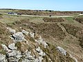
 Flagstaff Quarry from Parc Quarry - geograph.org.uk - 378095.jpg 640 × 480; 70 KB
-
 Footbridge over the Irwell - geograph.org.uk - 372681.jpg 427 × 640; 104 KB
-
 Fox Covert, East Tanfield. - geograph.org.uk - 373143.jpg 480 × 640; 176 KB
-
 Frith Bank daffodils - geograph.org.uk - 372904.jpg 640 × 427; 93 KB
-

-
 Garden centre - geograph.org.uk - 372713.jpg 640 × 481; 57 KB
-
 Gardener raking at Cranborne Manor - geograph.org.uk - 373987.jpg 640 × 508; 161 KB
-
 Gate lodge - geograph.org.uk - 374880.jpg 640 × 424; 49 KB
-
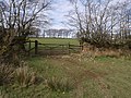
 Gate near Ballymartin - geograph.org.uk - 372899.jpg 640 × 426; 141 KB
-
 Gate near Black Bangworthy Cottage - geograph.org.uk - 380415.jpg 640 × 480; 147 KB
-
 General Roy monument, Hampton Hill. - geograph.org.uk - 373787.jpg 640 × 480; 99 KB
-
 General Roy monument, Hampton Hill. - geograph.org.uk - 373804.jpg 509 × 640; 161 KB
-
-
 Goleudy Trwyn Du Lighthouse - geograph.org.uk - 373631.jpg 640 × 480; 46 KB
-

-
 Grafton House - geograph.org.uk - 372941.jpg 640 × 480; 104 KB
-
 Grazing Pony at Hatchet Pond. - geograph.org.uk - 373055.jpg 640 × 471; 102 KB
-
 Green Lane near Denford Ash - geograph.org.uk - 373569.jpg 640 × 480; 102 KB
-
 Green Lane with Blackthorn blossom - geograph.org.uk - 373574.jpg 640 × 480; 110 KB
-
 Green lane, Syderstone - geograph.org.uk - 372920.jpg 640 × 480; 108 KB
-
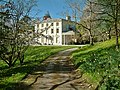 Greenway House - geograph.org.uk - 1057809.jpg 640 × 480; 284 KB
-
 Guild House at East Knapton - geograph.org.uk - 372984.jpg 640 × 480; 115 KB
-
 Hale Bank Wesleyan Methodist Chapel - geograph.org.uk - 374345.jpg 640 × 480; 76 KB
-
 Halebank Oddfellows Hall - geograph.org.uk - 374350.jpg 640 × 480; 116 KB
-
 Hall Wood, Swadlincote - geograph.org.uk - 372915.jpg 640 × 480; 84 KB
-
 Hampton School - geograph.org.uk - 373778.jpg 640 × 430; 79 KB
-
 Hargreaves' Depot - geograph.org.uk - 372810.jpg 640 × 475; 89 KB
-
 Hartlip Endowed CE Primary School - geograph.org.uk - 375148.jpg 640 × 479; 130 KB
-
 Hartsop Dodd - geograph.org.uk - 374802.jpg 640 × 480; 95 KB
-
 Hatchet Pond Copse, New Forest. - geograph.org.uk - 373072.jpg 640 × 476; 91 KB
-
 Hatchet Pond Facing West. - geograph.org.uk - 373067.jpg 640 × 474; 106 KB
-
 Hatchet Pond. - geograph.org.uk - 373046.jpg 640 × 480; 73 KB
-

-
 Heptonstall Pace Egg Play, Weavers Square - geograph.org.uk - 818914.jpg 640 × 427; 127 KB
-
 Here endeth the path - geograph.org.uk - 375011.jpg 640 × 480; 90 KB


.jpg)
.jpg)


,_Wolverhampton_-_geograph.org.uk_-_373094.jpg)


