Category:US National Archives series: Maps of the French Artillery Survey Group, 1917 - ca. 1919
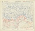
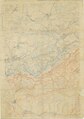
This series consists of artillery maps of France and Belgium, topographic maps of France and Italy, trench maps of France, bombardment and night aviation maps, photo maps, town area maps, and panoramic sketches. In addition to the Plans Directeurs are artillery maps overprinted to show artillery objectives, the state of destruction of enemy positions along the front, and details of works and communications.
The bombardment maps consist of 1:5,000 sheets showing industrial sites in Alsace and around Conflans-Jarny. The night aviation maps consist of topographic maps with main cities, towns, railroads, roads, hydrographic features, and woods printed in color to facilitate identification from the air at night. The panoramic sketches consist of printed wide angle views emphasizing significant terrain features visible from particular observation posts along the French front. Many of the sketches are not dated or identified.
Media in category "US National Archives series: Maps of the French Artillery Survey Group, 1917 - ca. 1919"
The following 7 files are in this category, out of 7 total.
-

-

-
 Trench Map, Apremont - DPLA - 698ebb2b084f8e350627ff589720b6b9 (page 1).jpg 8,352 × 12,691; 11.21 MB
-
 Trench Map, Foret D'Apremont - DPLA - 5cdfc21feb939c6d13998bd9906e9281 (page 1).jpg 9,504 × 8,458; 7.68 MB
-
 Trench Map, Foret D'Apremont - DPLA - 5cdfc21feb939c6d13998bd9906e9281 (page 2).pdf 4,750 × 4,227; 7.69 MB
-
 Verdun A Trench Map - DPLA - a8352961d064fab0bbf8971a29d9dac7 (page 1).jpg 8,640 × 12,262; 12.4 MB
-
 Verdun A Trench Map - DPLA - a8352961d064fab0bbf8971a29d9dac7 (page 2).pdf 4,318 × 6,129; 12.41 MB
.jpg)
.jpg)
.jpg)
.jpg)