Category:Tufertschwil
Jump to navigation
Jump to search
| Object location | | View all coordinates using: OpenStreetMap |
|---|
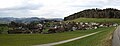
hamlet near Lütisburg  | |||||
| Upload media | |||||
| Instance of | |||||
|---|---|---|---|---|---|
| Location | Lütisburg, Toggenburg Constituency, canton St. Gallen, Switzerland | ||||
 | |||||
Subcategories
This category has the following 2 subcategories, out of 2 total.
O
Media in category "Tufertschwil"
The following 3 files are in this category, out of 3 total.
-
 Tufertschwil Altes Rathaus.jpg 4,352 × 3,264; 3.17 MB
-
 Tufertschwil Dorfeingang.jpg 4,352 × 3,264; 2.22 MB
-
 Tufertschwil.jpg 5,933 × 2,251; 1.93 MB

