Category:Kapelle St. Bartholomäus (Tufertschwil)
Jump to navigation
Jump to search
| Object location | | View all coordinates using: OpenStreetMap |
|---|
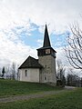
chapel in Tufertschwil  | |||||
| Upload media | |||||
| Instance of | |||||
|---|---|---|---|---|---|
| Location |
| ||||
| Street address |
| ||||
| Heritage designation | |||||
 | |||||
Media in category "Kapelle St. Bartholomäus (Tufertschwil)"
The following 5 files are in this category, out of 5 total.
-
 Kapelle St. Bartholomäus Tufertschwil 01.jpg 3,264 × 4,352; 1.77 MB
-
 Kapelle St. Bartholomäus Tufertschwil 02.jpg 4,352 × 3,264; 1.54 MB
-
 Kapelle St. Bartholomäus Tufertschwil 03.jpg 4,352 × 3,264; 1.67 MB
-
 Kapelle St. Bartholomäus Tufertschwil Altar.jpg 2,996 × 3,995; 1.74 MB
-
 Kapelle St. Bartholomäus Tufertschwil Innenraum.jpg 4,320 × 3,221; 1.57 MB


