Category:Three Holes Cross
Jump to navigation
Jump to search
medieval wayside cross and road junction in Cornwall, England, UK  | |||||
| Upload media | |||||
| Instance of | |||||
|---|---|---|---|---|---|
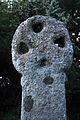
| Location | Egloshayle, Cornwall, South West England, England | ||||
| Heritage designation |
| ||||
 | |||||
English: Three Holes Cross is a crossroads on the A39 trunk road approximately 2 miles east of Wadebridge, Cornwall, United Kingdom at . There is also a settlement of a few houses nearby. The name is derived from the Cornish Cross sited there. The nearest house, a little way away from the cross was the toll house in olden days to get into Wadebridge.
Media in category "Three Holes Cross"
The following 7 files are in this category, out of 7 total.
-
 Killiburry DSC 9307.jpg 2,848 × 4,288; 8.53 MB
-
 Killiburry DSC 9309.jpg 2,848 × 4,288; 6.89 MB
-
 Killiburry DSC 9315.jpg 2,848 × 4,288; 8.59 MB
-
 Killiburry DSC 9318.jpg 2,848 × 4,288; 8.07 MB
-
 Killiburry DSC 9319.jpg 2,848 × 4,288; 9.66 MB
-
 Three Holes Cross - geograph.org.uk - 205657.jpg 462 × 640; 150 KB
-
 Three Holes Cross.jpg 1,500 × 2,086; 4.04 MB


