Category:Egloshayle
Jump to navigation
Jump to search
village in the north of Cornwall, UK  | |||||
| Upload media | |||||
| Instance of | |||||
|---|---|---|---|---|---|
| Location | Cornwall, South West England, England | ||||
| Population |
| ||||
 | |||||
Subcategories
This category has the following 9 subcategories, out of 9 total.
C
K
- Kelly Rounds (2 F)
L
- Lower Tregleath Ford (3 F)
P
- Pencarrow House (25 F)
- Polbrock (10 F)
S
- Sladesbridge (15 F)
T
- Three Holes Cross (7 F)
- Trevilder (3 F)
- Trewornan Bridge (6 F)
Media in category "Egloshayle"
The following 200 files are in this category, out of 324 total.
(previous page) (next page)-

-
 A389 at Lane End (geograph 6388620).jpg 4,046 × 2,572; 1.23 MB
-
 A389 at Washaway - geograph.org.uk - 6388632.jpg 4,288 × 2,848; 2.56 MB
-
 A389 at Washaway - geograph.org.uk - 6388737.jpg 4,288 × 2,848; 2.67 MB
-
 A39 east of Wadebridge - geograph.org.uk - 5692527.jpg 1,636 × 966; 176 KB
-
 Across the Camel estuary - geograph.org.uk - 5395138.jpg 3,072 × 1,565; 892 KB
-
 Across the Camel estuary - geograph.org.uk - 5395491.jpg 3,072 × 1,373; 605 KB
-
 Amble flood plain from the B3314 - geograph.org.uk - 5699471.jpg 4,260 × 2,591; 1.62 MB
-
 Amble from Trewornan Bridge - geograph.org.uk - 5699462.jpg 4,281 × 2,594; 1.31 MB
-
 Amble valley from the B3314 - geograph.org.uk - 5699351.jpg 4,104 × 2,300; 1.61 MB
-
 Amble valley from the B3314 - geograph.org.uk - 5699359.jpg 4,288 × 2,848; 1.34 MB
-
 Arable field near Costislost - geograph.org.uk - 6388769.jpg 4,288 × 2,848; 2.06 MB
-
 Arable field, Treworder - geograph.org.uk - 5673584.jpg 4,288 × 2,848; 1.21 MB
-
 B3314 approaching Trewornan Bridge - geograph.org.uk - 5699343.jpg 4,266 × 2,708; 2.13 MB
-
 B3314 at Bodieve - geograph.org.uk - 5698700.jpg 4,288 × 2,848; 2.07 MB
-
 B3314 near Bodieve - geograph.org.uk - 5698940.jpg 1,921 × 2,115; 772 KB
-
 Bridge over Camel Trail - geograph.org.uk - 5420003.jpg 3,072 × 2,048; 1.51 MB
-
 Bridge over River Camel at Grogley Moor - geograph.org.uk - 2849098.jpg 800 × 600; 557 KB
-

-
 Bridge, leat and river at Lemail Mill - geograph.org.uk - 5673729.jpg 4,288 × 2,848; 2.36 MB
-
 Bridleway in Allen valley - geograph.org.uk - 5673716.jpg 2,848 × 4,288; 2.68 MB
-
 Bridleway, Mutton's Wood - geograph.org.uk - 5674411.jpg 4,288 × 2,848; 2.56 MB
-
 Bridleway, Mutton's Wood - geograph.org.uk - 5674415.jpg 4,288 × 2,848; 2.66 MB
-
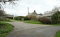
 Burniere Cottages - geograph.org.uk - 5699115.jpg 4,267 × 2,716; 2.17 MB
-
 By the A389 at Pencarrow Mill - geograph.org.uk - 5734894.jpg 4,288 × 2,493; 1.94 MB
-
 Camel and Camel Trail - geograph.org.uk - 5419780.jpg 3,072 × 2,048; 1.39 MB
-
 Camel and Camel Trail - geograph.org.uk - 5419794.jpg 3,072 × 2,048; 1.67 MB
-
 Camel Trail - geograph.org.uk - 5196639.jpg 1,600 × 1,067; 845 KB
-
 Camel Trail - geograph.org.uk - 5196658.jpg 1,600 × 1,067; 948 KB
-
 Camel Trail - geograph.org.uk - 5196800.jpg 1,600 × 1,067; 980 KB
-
 Camel Trail - geograph.org.uk - 5419740.jpg 3,072 × 2,048; 1.56 MB
-
 Camel Trail - geograph.org.uk - 5420125.jpg 3,024 × 1,907; 1.53 MB
-
 Camel Trail - geograph.org.uk - 5420281.jpg 3,072 × 2,048; 1.53 MB
-
 Camel Trail - geograph.org.uk - 5420368.jpg 3,072 × 2,048; 1.82 MB
-
 Camel Trail - geograph.org.uk - 5420489.jpg 2,048 × 3,072; 2.02 MB
-

-
 Camel Trail approaching Polbrook - geograph.org.uk - 5419981.jpg 3,072 × 2,048; 1.59 MB
-

-

-
 Camel trail Feb2008.JPG 3,072 × 2,304; 3.21 MB
-
 Camel Trail in Polgeel Wood - geograph.org.uk - 2849023.jpg 600 × 800; 511 KB
-
 Camel Trail opposite Cottonwood - geograph.org.uk - 2848187.jpg 600 × 800; 527 KB
-

-
 Camel valley - geograph.org.uk - 5419759.jpg 3,072 × 2,048; 1.61 MB
-
 Camel valley near Grogley - geograph.org.uk - 5420243.jpg 3,072 × 2,048; 1.28 MB
-
 Camel Valley Vinyard. - panoramio.jpg 3,648 × 2,736; 4.74 MB
-
 Car wash at the garden centre - geograph.org.uk - 2468935.jpg 1,558 × 1,149; 949 KB
-
 Carrick , House beside the A389 - geograph.org.uk - 2512204.jpg 4,216 × 2,736; 3.97 MB
-
 Cattle in the field nr Higham Mill - geograph.org.uk - 2099417.jpg 640 × 412; 76 KB
-
 Cattle in the River - geograph.org.uk - 202965.jpg 640 × 446; 130 KB
-
 Church of St Conan, Washaway - geograph.org.uk - 6388643.jpg 4,288 × 2,848; 2.37 MB
-
 Church of St Conan, Washaway - geograph.org.uk - 6388645.jpg 4,284 × 2,569; 1.8 MB
-
 Cornwall , Bozion Cottage - geograph.org.uk - 5467658.jpg 6,000 × 4,000; 7.04 MB
-
 Cornwall , Camel Trail - geograph.org.uk - 5467594.jpg 6,000 × 4,000; 6.01 MB
-
 Cornwall , Camel Trail - geograph.org.uk - 5467596.jpg 6,000 × 4,000; 7.47 MB
-
 Cornwall , Camel Trail - geograph.org.uk - 5467602.jpg 6,000 × 4,000; 7.5 MB
-
 Cornwall , Camel Trail - geograph.org.uk - 5467603.jpg 6,000 × 4,000; 5.91 MB
-
 Cornwall , Camel Trail - geograph.org.uk - 5467606.jpg 6,000 × 4,000; 6.03 MB
-
 Cornwall , Camel Trail - geograph.org.uk - 5467634.jpg 6,000 × 4,000; 6.67 MB
-
 Cornwall , Conservation Walk - geograph.org.uk - 5467609.jpg 6,000 × 4,000; 5.72 MB
-
 Cornwall , Country Lane - geograph.org.uk - 5467519.jpg 6,000 × 4,000; 5.98 MB
-
 Cornwall , Country Lane - geograph.org.uk - 5467641.jpg 6,000 × 4,000; 5.92 MB
-
 Cornwall , Country Lane - geograph.org.uk - 5467646.jpg 6,000 × 4,000; 5.78 MB
-
 Cornwall , Country Lane - geograph.org.uk - 5467648.jpg 6,000 × 4,000; 7.26 MB
-
 Cornwall , Country Lane - geograph.org.uk - 5467652.jpg 6,000 × 4,000; 6.76 MB
-
 Cornwall , Country Lane - geograph.org.uk - 5467654.jpg 6,000 × 4,000; 5.9 MB
-
 Cornwall , Country Lane - geograph.org.uk - 5467660.jpg 6,000 × 4,000; 6.95 MB
-
 Cornwall , Countryside Scenery - geograph.org.uk - 5467650.jpg 6,000 × 4,000; 7.66 MB
-
 Cornwall , Countryside Scenery - geograph.org.uk - 5467656.jpg 6,000 × 4,000; 7.04 MB
-
 Cornwall , Countryside Scenery - geograph.org.uk - 5467661.jpg 6,000 × 4,000; 5.12 MB
-
 Cornwall , Countryside Scenery - geograph.org.uk - 5467662.jpg 6,000 × 4,000; 5.97 MB
-
 Cornwall , Footpath - geograph.org.uk - 5467523.jpg 6,000 × 4,000; 6.11 MB
-
 Cornwall , Footpath - geograph.org.uk - 5467580.jpg 6,000 × 4,000; 6.64 MB
-
 Cornwall , Grassland - geograph.org.uk - 5467611.jpg 6,000 × 4,000; 6.29 MB
-
 Cornwall , Grassy Field - geograph.org.uk - 5467659.jpg 6,000 × 4,000; 6.39 MB
-
 Cornwall , Grassy Field ^ Gate - geograph.org.uk - 5467588.jpg 6,000 × 4,000; 6.41 MB
-
 Cornwall , Grassy Path - geograph.org.uk - 5467581.jpg 6,000 × 4,000; 6.09 MB
-
 Cornwall , Grassy Path - geograph.org.uk - 5467583.jpg 6,000 × 4,000; 6.55 MB
-
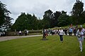
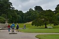
 Cornwall , Pencarrow Gardens - geograph.org.uk - 5467668.jpg 5,467 × 3,644; 7.16 MB
-
 Cornwall , Pencarrow Gardens - geograph.org.uk - 5467671.jpg 6,000 × 4,000; 7.21 MB
-
 Cornwall , Pencarrow Gardens - geograph.org.uk - 5467672.jpg 6,000 × 4,000; 6.54 MB
-
 Cornwall , Pencarrow Gardens - geograph.org.uk - 5467674.jpg 6,000 × 4,000; 6.7 MB
-
 Cornwall , Pencarrow Gardens - geograph.org.uk - 5467676.jpg 6,000 × 4,000; 5.72 MB
-
 Cornwall , Pencarrow Gardens - geograph.org.uk - 5467678.jpg 6,000 × 4,000; 7.09 MB
-
 Cornwall , Pencarrow Gardens - geograph.org.uk - 5467680.jpg 6,000 × 4,000; 5.72 MB
-
 Cornwall , Pencarrow Gardens - geograph.org.uk - 5467683.jpg 6,000 × 4,000; 7.7 MB
-
 Cornwall , Pencarrow Gardens - geograph.org.uk - 5467684.jpg 4,000 × 6,000; 5.27 MB
-
 Cornwall , Pencarrow Gardens - geograph.org.uk - 5467685.jpg 6,000 × 4,000; 7.75 MB
-
 Cornwall , Pencarrow Gardens - geograph.org.uk - 5467686.jpg 6,000 × 4,000; 5.67 MB
-
 Cornwall , Pencarrow Gardens - geograph.org.uk - 5467689.jpg 6,000 × 4,000; 5.88 MB
-
 Cornwall , Pencarrow Gardens - geograph.org.uk - 5467690.jpg 6,000 × 4,000; 7.11 MB
-
 Cornwall , Pencarrow Gardens - geograph.org.uk - 5467691.jpg 6,000 × 4,000; 4.94 MB
-
 Cornwall , Pencarrow Gardens - geograph.org.uk - 5467692.jpg 6,000 × 4,000; 6.16 MB
-
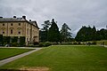
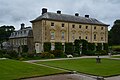
 Cornwall , Pencarrow House - geograph.org.uk - 5467670.jpg 6,000 × 4,000; 4.75 MB
-
 Cornwall , Pencarrow House - geograph.org.uk - 5467673.jpg 6,000 × 4,000; 7.62 MB
-
 Cornwall , Pencarrow House - geograph.org.uk - 5467677.jpg 6,000 × 4,000; 6.36 MB
-
 Cornwall , Pencarrow House - geograph.org.uk - 5467681.jpg 6,000 × 4,000; 5.74 MB
-
 Cornwall , Pencarrow House - geograph.org.uk - 5467688.jpg 6,000 × 4,000; 6.65 MB
-
 Cornwall , Steps - geograph.org.uk - 5467636.jpg 4,000 × 6,000; 6.69 MB
-
 Cornwall , The A389 - geograph.org.uk - 5467663.jpg 6,000 × 4,000; 6.76 MB
-
 Cornwall , Track - geograph.org.uk - 5467697.jpg 6,000 × 4,000; 7.04 MB
-
 Costislost entrance - geograph.org.uk - 448598.jpg 640 × 480; 171 KB
-
 Derry's Wood across the River Camel - geograph.org.uk - 2849037.jpg 600 × 800; 484 KB
-
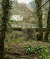
 Dilapidated bridge at Lemail Mill - geograph.org.uk - 5673957.jpg 4,288 × 2,848; 2.15 MB
-
 Doorway at Pencarow House - geograph.org.uk - 3981566.jpg 640 × 481; 114 KB
-
 Farm Buildings - geograph.org.uk - 783831.jpg 600 × 450; 164 KB
-
 Farmland near the Amble - geograph.org.uk - 5699253.jpg 3,387 × 1,475; 592 KB
-
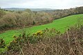
 Farmland southwest of St Mabyn - geograph.org.uk - 5260975.jpg 3,072 × 2,048; 1.15 MB
-
 Field boundary at Kestle - geograph.org.uk - 2520526.jpg 640 × 480; 76 KB
-
 Field by lane to Trevilder - geograph.org.uk - 5421650.jpg 2,839 × 1,722; 1.13 MB
-
 Field by the A389 - geograph.org.uk - 6388637.jpg 4,288 × 2,848; 1.64 MB
-

-
 Field near Burniere - geograph.org.uk - 5699104.jpg 4,087 × 2,523; 1.8 MB
-
 Field of maize above Lower Croan - geograph.org.uk - 2520535.jpg 640 × 480; 96 KB
-
 Field of Maize nr St Mabyn - geograph.org.uk - 2099446.jpg 640 × 423; 63 KB
-
 Field, Lane End - geograph.org.uk - 6388624.jpg 4,288 × 2,848; 2.44 MB
-
 Field, Trevilder - geograph.org.uk - 5260967.jpg 1,858 × 1,079; 545 KB
-
 Fields by River Amble - geograph.org.uk - 4185897.jpg 1,600 × 800; 900 KB
-
-
 Footpath to Chapel Amble - geograph.org.uk - 5699255.jpg 2,935 × 1,426; 662 KB
-
 Ford at Lower Tregleath - geograph.org.uk - 5139420.jpg 6,000 × 4,000; 7.34 MB
-
 Ford, Lands - geograph.org.uk - 6390857.jpg 3,788 × 2,439; 1.85 MB
-
 Former quarry by Camel Trail - geograph.org.uk - 5420286.jpg 3,072 × 2,048; 1.74 MB
-
 Former railway bridge over River Camel - geograph.org.uk - 5420355.jpg 1,574 × 1,852; 916 KB
-
 Former Tollhouse by the A39, Three Holes Cross - geograph.org.uk - 6083711.jpg 1,024 × 634; 343 KB
-
 Gates at Trevilder crossroads - geograph.org.uk - 5421684.jpg 3,071 × 1,834; 1.02 MB
-
 Grass triangle, Maryland Cottages - geograph.org.uk - 6388752.jpg 3,075 × 1,676; 1.07 MB
-
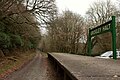 Grogley Halt - geograph.org.uk - 5420336.jpg 3,072 × 2,048; 1.42 MB
-
 Grogley Halt platform on the Camel Trail - geograph.org.uk - 4175840.jpg 640 × 480; 152 KB
-
 Gunnera Manicata leaves at Pencarrow - geograph.org.uk - 3981576.jpg 640 × 480; 129 KB
-
 Hairpin bend near Lower Burlorne - geograph.org.uk - 2519963.jpg 640 × 480; 121 KB
-
 Higher Treworder - geograph.org.uk - 5670412.jpg 4,288 × 2,634; 1.14 MB
-
 Hillside by Camel Trail - geograph.org.uk - 5420249.jpg 2,690 × 1,887; 1.11 MB
-
 Hingham Mill - geograph.org.uk - 2520573.jpg 640 × 480; 94 KB
-
 Houses at Polbrock Bridge by Camel Trail - geograph.org.uk - 2848990.jpg 600 × 800; 460 KB
-
 In the Allen valley - geograph.org.uk - 5674389.jpg 4,288 × 2,848; 1.68 MB
-
 Junction at Grogley Halt - geograph.org.uk - 5420300.jpg 3,072 × 2,048; 1.39 MB
-

-
 Kestle Quarry - geograph.org.uk - 5421602.jpg 3,072 × 2,048; 1.24 MB
-

-
 Lane at Polbrook - geograph.org.uk - 5420094.jpg 2,048 × 3,072; 1.59 MB
-
 Lane from Polbrock - geograph.org.uk - 6390868.jpg 2,868 × 1,790; 1,005 KB
-
 Lane leading towards St Mabyn - geograph.org.uk - 2099494.jpg 640 × 425; 75 KB
-
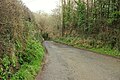
 Lane near Lower Burlorne - geograph.org.uk - 6390866.jpg 4,288 × 2,848; 1.95 MB
-

-
 Lane to Hingham Mill - geograph.org.uk - 5673707.jpg 3,845 × 2,509; 2.22 MB
-
 Lane to Lands - geograph.org.uk - 6390872.jpg 4,089 × 2,399; 1.73 MB
-
 Lane to Lemail - geograph.org.uk - 5673722.jpg 4,180 × 2,269; 1.98 MB
-
 Lane to Lemail Mill - geograph.org.uk - 5673704.jpg 4,288 × 2,848; 2.2 MB
-
 Lane to Pendavey - geograph.org.uk - 6389392.jpg 4,288 × 2,848; 2.2 MB
-
 Lane to Polbrock - geograph.org.uk - 6390607.jpg 4,129 × 2,422; 1.97 MB
-
 Lane to St Mabyn - geograph.org.uk - 5421688.jpg 2,485 × 1,642; 867 KB
-
 Lane to Tregleath - geograph.org.uk - 6388628.jpg 2,848 × 4,288; 1.88 MB
-
 Lane to Trevilder - geograph.org.uk - 5421670.jpg 2,835 × 1,782; 862 KB
-
 Lane to Washaway - geograph.org.uk - 6389386.jpg 4,148 × 2,591; 1.94 MB
-
 Lay-by near Trewornan Bridge - geograph.org.uk - 3437184.jpg 848 × 636; 118 KB
-
 Lay-by on A39 - geograph.org.uk - 5692522.jpg 3,573 × 2,292; 885 KB
-

-
 Leaning signpost at the road junction - geograph.org.uk - 2098839.jpg 640 × 429; 109 KB
-
 Leat at Lemail Mill - geograph.org.uk - 5673735.jpg 4,288 × 2,848; 2.76 MB
-
 Looking into a field in the rain near Trevilder - geograph.org.uk - 5832576.jpg 1,024 × 768; 239 KB
-
 Lower Tregleath - geograph.org.uk - 849678.jpg 640 × 426; 84 KB
-
 Marshy ground, Trevilling - geograph.org.uk - 5709911.jpg 4,288 × 2,848; 2.96 MB
-
 Marshy land by the River Camel - geograph.org.uk - 2849070.jpg 800 × 600; 405 KB
-
 Maryland Cottages - geograph.org.uk - 6388759.jpg 4,279 × 2,708; 1.78 MB
-
 Minor road from Pendavey to Sladesbridge - geograph.org.uk - 2520154.jpg 640 × 480; 101 KB
-
 Minor Road nr Bozion Farm - geograph.org.uk - 2098834.jpg 640 × 445; 91 KB
-
 Muttons - geograph.org.uk - 5674419.jpg 4,288 × 2,848; 2.38 MB
-
 National Cycle Route 32 - Camel Trail - geograph.org.uk - 690296.jpg 640 × 427; 296 KB
-
 NCN Millennium Milepost MP2 Egloshayle Cornwall.jpeg 1,850 × 2,595; 991 KB
-
 North Cornwall , Country Lane - geograph.org.uk - 3862638.jpg 4,284 × 2,842; 4.25 MB
-
 North Cornwall , The A389 - geograph.org.uk - 3862650.jpg 4,282 × 2,838; 5.15 MB
-
 North Cornwall , The A389 - geograph.org.uk - 3862656.jpg 4,288 × 2,848; 5.69 MB
-
 North Cornwall , The A389 - geograph.org.uk - 3862658.jpg 3,992 × 2,276; 3.77 MB
-
 North Cornwall , The A389 - geograph.org.uk - 3862662.jpg 4,288 × 2,848; 6.96 MB
-
 North Cornwall , The A389 - geograph.org.uk - 3862666.jpg 4,288 × 2,848; 6.15 MB
-
 North Cornwall , The A389 - geograph.org.uk - 3862674.jpg 4,288 × 2,848; 5.92 MB
-
 North Cornwall , The A389 - geograph.org.uk - 3862689.jpg 4,288 × 2,848; 5.23 MB
-
 North Cornwall , The A389 - geograph.org.uk - 3862775.jpg 4,288 × 2,848; 5.19 MB
-
 North Cornwall , The A389 - geograph.org.uk - 3862778.jpg 4,288 × 2,848; 5.52 MB
-
 North Cornwall , The B3266 - geograph.org.uk - 3862635.jpg 4,192 × 2,698; 4.59 MB
-
 Old Boundary Marker - geograph.org.uk - 6429266.jpg 678 × 905; 268 KB
-
 Old Boundary Marker - geograph.org.uk - 6429276.jpg 747 × 857; 268 KB
-

-

-

-

-
 Orienteering in Dunmere Woods - geograph.org.uk - 2519558.jpg 640 × 480; 139 KB
-
-
 Path off the Camel Trail - geograph.org.uk - 5419734.jpg 2,048 × 3,072; 1.57 MB
-
 Penaligon Downs - geograph.org.uk - 849575.jpg 640 × 423; 114 KB
-
 Pencarrow House - geograph.org.uk - 6138173.jpg 1,024 × 768; 225 KB
-
 Pencarrow House - geograph.org.uk - 6138204.jpg 1,024 × 768; 205 KB
-
 Pencarrow House and Gardens - geograph.org.uk - 4676338.jpg 3,678 × 2,456; 5.52 MB
-
 Pencarrow House and Gardens, Gunnera in the Moles Garden - geograph.org.uk - 4676305.jpg 3,679 × 2,455; 6.02 MB
-
 Pencarrow House and Gardens, Hydrangea by the lake - geograph.org.uk - 4676322.jpg 3,678 × 2,456; 4.54 MB
-
 Pencarrow House and Gardens, Stream in the Moles Garden - geograph.org.uk - 4676293.jpg 3,678 × 2,456; 5.15 MB
-
 Pencarrow House and Gardens, Sundial - geograph.org.uk - 4676344.jpg 3,591 × 2,316; 3.94 MB
-
 Pencarrow House and Gardens, The lake - geograph.org.uk - 4676320.jpg 4,428 × 2,934; 6.86 MB
-
 Pencarrow House and Gardens, The ornamental fountain - geograph.org.uk - 4676334.jpg 5,294 × 3,304; 7.58 MB

.jpg)


