Category:Temporal population graphs of Thuringia
Jump to navigation
Jump to search
Federal states of Germany:
Subcategories
This category has the following 6 subcategories, out of 6 total.
Media in category "Temporal population graphs of Thuringia"
The following 81 files are in this category, out of 81 total.
-
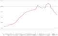 Altenburg Population Statistics.png 997 × 625; 22 KB
-
 Population Statistics Altenburg.png 910 × 562; 59 KB
-
 Bad Salzungen develop.png 1,320 × 885; 27 KB
-
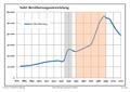 Bevölkerungsentwicklung Suhl.pdf 1,752 × 1,239; 95 KB
-
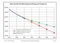 Bevölkerungsprognosen Suhl.pdf 1,752 × 1,239; 96 KB
-
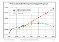 Bevölkerungsprognosen Weimar.pdf 1,752 × 1,239; 97 KB
-
 Einwohnerentwicklung Boehlen 1815 2007.JPG 1,037 × 702; 64 KB
-
 Einwohnerentwicklung von Altenbeuthen.svg 800 × 400; 56 KB
-
 Einwohnerentwicklung von Altenburg - ab 1871.svg 800 × 400; 65 KB
-
 Einwohnerentwicklung von Altenburg - Prognosen.svg 800 × 400; 48 KB
-
 Einwohnerentwicklung von Altenburg.svg 800 × 400; 78 KB
-
 Einwohnerentwicklung von Apolda - Prognosen.svg 800 × 400; 48 KB
-
 Einwohnerentwicklung von Apolda.svg 800 × 400; 57 KB
-
 Einwohnerentwicklung von Arnstadt.svg 800 × 400; 69 KB
-
 Einwohnerentwicklung von Bad Salzungen.svg 800 × 400; 60 KB
-
 Einwohnerentwicklung von Birkenfelde.svg 800 × 400; 57 KB
-
 Einwohnerentwicklung von Blankenstein.svg 800 × 400; 65 KB
-
 Einwohnerentwicklung von Bornhagen.svg 800 × 400; 28 KB
-
 Einwohnerentwicklung von Daberstedt.svg 800 × 400; 32 KB
-
 Einwohnerentwicklung von Eisenberg (Thüringen).svg 800 × 400; 65 KB
-
 Einwohnerentwicklung von Eisfeld - ab 1871.svg 800 × 400; 57 KB
-
 Einwohnerentwicklung von Eisfeld.svg 800 × 400; 76 KB
-
 Einwohnerentwicklung von Friedrichroda.svg 800 × 400; 54 KB
-
 Einwohnerentwicklung von Greiz.svg 800 × 400; 30 KB
-
 Einwohnerentwicklung von Heilbad Heiligenstadt.svg 800 × 400; 57 KB
-
 Einwohnerentwicklung von Hildburghausen.svg 800 × 400; 60 KB
-
 Einwohnerentwicklung von Hirschberg (Saale).svg 800 × 400; 61 KB
-
 Einwohnerentwicklung von Ilmenau (log10).svg 800 × 400; 76 KB
-
 Einwohnerentwicklung von Ilmenau - ab 1871.svg 800 × 400; 60 KB
-
 Einwohnerentwicklung von Kalbsrieth.svg 800 × 400; 43 KB
-
 Einwohnerentwicklung von Katzhütte.svg 800 × 400; 66 KB
-
 Einwohnerentwicklung von Kella.svg 800 × 400; 42 KB
-
 Einwohnerentwicklung von Kölleda - ab 1871.svg 800 × 400; 27 KB
-
 Einwohnerentwicklung von Kölleda.svg 800 × 400; 33 KB
-
 Einwohnerentwicklung von Landkreis Gotha.svg 800 × 400; 38 KB
-
 Einwohnerentwicklung von Meiningen - ab 1871.svg 800 × 400; 27 KB
-
 Einwohnerentwicklung von Meiningen - Prognosen.svg 800 × 400; 72 KB
-
 Einwohnerentwicklung von Meiningen.svg 800 × 400; 35 KB
-
 Einwohnerentwicklung von Mühlhausen-Thüringen - ab 1871.svg 800 × 400; 58 KB
-
 Einwohnerentwicklung von Mühlhausen-Thüringen.svg 800 × 400; 62 KB
-
 Einwohnerentwicklung von Neusiß.svg 800 × 400; 56 KB
-
 Einwohnerentwicklung von Nobitz - ab 1871.svg 800 × 400; 58 KB
-
 Einwohnerentwicklung von Nobitz.svg 800 × 400; 54 KB
-
 Einwohnerentwicklung von Ohrdruf.svg 800 × 400; 52 KB
-
 Einwohnerentwicklung von Pölzig - ab 1871.svg 800 × 400; 44 KB
-
 Einwohnerentwicklung von Pölzig.svg 800 × 400; 41 KB
-
 Einwohnerentwicklung von Rudolstadt.svg 800 × 400; 66 KB
-
 Einwohnerentwicklung von Rustenfelde.svg 800 × 400; 57 KB
-
 Einwohnerentwicklung von Römhild (log10).svg 800 × 400; 57 KB
-
 Einwohnerentwicklung von Römhild - ab 1871.svg 800 × 400; 49 KB
-
 Einwohnerentwicklung von Römhild.svg 800 × 400; 59 KB
-
 Einwohnerentwicklung von Saalfeld (Saale).svg 800 × 400; 66 KB
-
 Einwohnerentwicklung von Schleusingen.svg 800 × 400; 63 KB
-
 Einwohnerentwicklung von Schwarzburg.svg 800 × 400; 59 KB
-
 Einwohnerentwicklung von Sondershausen - ab 1871.svg 800 × 400; 53 KB
-
 Einwohnerentwicklung von Sondershausen.svg 800 × 400; 70 KB
-
 Einwohnerentwicklung von Suhl - ab 1871.svg 800 × 400; 59 KB
-
 Einwohnerentwicklung von Suhl.svg 800 × 400; 58 KB
-
 Einwohnerentwicklung von Teichwitz.svg 800 × 400; 55 KB
-
 Einwohnerentwicklung von Thüringen.svg 800 × 400; 55 KB
-
 Einwohnerentwicklung von Waltershausen.svg 800 × 400; 62 KB
-
 Einwohnerentwicklung von Weimar.svg 800 × 400; 75 KB
-
 Einwohnerentwicklung von Zeulenroda-Triebes.svg 800 × 400; 74 KB
-
 Einwohnerentwicklung von Zimmernsupra.svg 800 × 400; 62 KB
-
 Einwohnerentwicklungkoelleda.png 971 × 684; 39 KB
-
 Population Statistics Greiz 2010.jpg 700 × 427; 246 KB
-
 Population Statistics Greiz.png 910 × 562; 59 KB
-
 Einwohnerentwicklung von Ilmenau ab 1700.svg 800 × 400; 30 KB
-
 Einwohnerentwicklung von Ilmenau.svg 800 × 400; 72 KB
-
 Ilmenau Einwohnerentwicklung.png 1,280 × 796; 17 KB
-
 Landkreis Saalfeld-Rudolstadt Bevoelkerungsentwicklung.svg 500 × 400; 15 KB
-
 Landkreis Sonneberg Bevoelkerungsentwicklung.svg 400 × 300; 15 KB
-
 Population Statistics Weimar.png 950 × 572; 49 KB
-
 Saale-Orla-Kreis Bevoelkerungsentwicklung.svg 800 × 400; 46 KB
-
 Einwohnerentwicklung von Sonneberg.svg 800 × 400; 66 KB
-
 Population Statistics Sonneberg.png 910 × 562; 63 KB
-
 Bevölkerung thüringen.png 593 × 281; 15 KB
-
 Population Thuringe.jpg 1,800 × 1,200; 142 KB
-
 Thueringen Einwohner.svg 400 × 200; 18 KB
-
 Weimar Einwohner.svg 800 × 400; 34 KB
-
 Zeulenroda Einwohnerentwicklung.png 1,329 × 808; 130 KB


.svg)


.svg)
.svg)


.svg)


.svg)


