Category:Tectonics maps
Jump to navigation
Jump to search
Subcategories
This category has the following 7 subcategories, out of 7 total.
Media in category "Tectonics maps"
The following 77 files are in this category, out of 77 total.
-
 JPVD-NGTM2023-Comp2.jpg 15,007 × 6,858; 10.58 MB
-
 The New Glocal Tectonic Map - Hemisphere Projections.jpg 1,753 × 919; 531 KB
-
 World geologic provinces.jpg 1,200 × 637; 115 KB
-
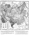 1937-Tectonic map Eurasia.jpg 2,990 × 3,630; 7.97 MB
-
 A Map of South China Craton.png 1,446 × 1,071; 423 KB
-

-
 Banda Arc tectonic map.jpg 868 × 1,158; 242 KB
-

-
 Capricorn Seamount-NOAA-Tectonic features hires (cropped).jpg 188 × 190; 75 KB
-
 Cascade Volcanic Arc.jpg 461 × 686; 84 KB
-
 Cascadia subduction zone USGS He.jpg 378 × 552; 40 KB
-
 Central Asia.tif 1,993 × 2,564; 19.51 MB
-
 External crystalline massifs of the Alps.png 1,533 × 1,155; 154 KB
-
 French Hercynian massifs BR.svg 850 × 590; 274 KB
-
 French Hercynian massifs EN.svg 850 × 590; 274 KB
-
 French Hercynian massifs NL.svg 850 × 590; 273 KB
-
 Geologische Strukturen des Rheinischen Schiefergebirges.jpg 1,927 × 1,306; 355 KB
-
 Geoviden-1-2011-Nordsøens-geologi.png 1,024 × 880; 212 KB
-
 Geoviden-1-2011-strukturkort-over-Bornholm.png 665 × 746; 103 KB
-
 Geoviden-1-2011-strukturkort-over-Danmark.png 1,171 × 845; 209 KB
-
 Geoviden-2-2010-dybde-til-underside-yngste-perm.tif 1,021 × 673; 1.09 MB
-
 Gliederung der Varisziden in Deutschland.jpg 1,323 × 1,356; 273 KB
-
 Gliederung der Varisziden in Mitteleuropa.jpg 1,910 × 1,290; 510 KB
-
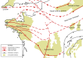
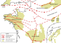
 Gpsavrasya.png 646 × 453; 219 KB
-
 Guide to common map symbols.png 506 × 645; 43 KB
-
 Iberian Tectonic EN.svg 382 × 485; 695 KB
-
 Juan de fuca plate.png 536 × 652; 46 KB
-
 Kanto fragment map.png 500 × 500; 22 KB
-
 Laamtektoonika.jpg 1,500 × 1,063; 421 KB
-
 Lau Basin-NOAA-Tectonic features hires.jpg 2,642 × 2,189; 4.65 MB
-
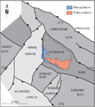
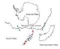 Macquarie triple junction picture.png 671 × 547; 51 KB
-
 Map of oblique subduction.png 2,190 × 1,188; 2.85 MB
-
 Map of oblique subduction1.png 2,186 × 1,162; 2.85 MB
-
 Map of os.png 2,185 × 1,161; 3.47 MB
-
 Maya Block USGS OF-97-470-L 1-2.tif 4,044 × 4,826; 80 MB
-
 New model of East African Rift.svg 537 × 746; 279 KB
-
 Oblique map.png 2,206 × 1,276; 2.85 MB
-
 Oblique subduction map 3.png 2,220 × 1,252; 2.85 MB
-
 Oblique subduction map updated.png 2,160 × 1,152; 2.95 MB
-
 Oblique subduction map updated1.png 2,216 × 1,254; 2.85 MB
-
 Oblique subduction map.png 1,408 × 724; 1.55 MB
-
 Old model of East African Rift 2.svg 538 × 749; 29 KB
-
 Old model of East African Rift.gif 538 × 749; 21 KB
-
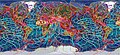
 Painted tectonic map.jpg 1,335 × 851; 175 KB
-
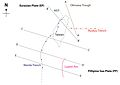
 Philippine plate tectonics and earthquakes.png 2,438 × 3,508; 5.22 MB
-
 Philippine plate tectonics, volcanoes, and subducting slabs.png 2,438 × 3,508; 3.6 MB
-
 Philippine plate tectonics, volcanoes, and trenches.png 2,438 × 3,508; 3.84 MB
-
 Platetectonics-haitiquake.jpg 2,267 × 1,324; 155 KB
-
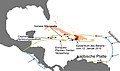 Plattentektonik Haitibeben.jpg 2,244 × 1,324; 156 KB
-
 Rift Haranaren eraketa.jpg 702 × 384; 44 KB
-
 Samoan Tectonic setting.png 473 × 521; 88 KB
-
 Simplified geological map of Sicily.svg 853 × 521; 474 KB
-
 SoCal Coast.jpg 720 × 1,084; 374 KB
-
 Stamps2008animated.pdf 706 × 1,285; 444 KB
-
 Sumatra sediment cropped.png 861 × 623; 538 KB
-
 Sumatra sediment difference.png 1,242 × 625; 763 KB
-
 Sumatra subduction 2.png 1,900 × 1,168; 1.49 MB
-
 Sumatra subduction.png 1,936 × 1,170; 1.5 MB
-
 Tai Wan crosssection -01.svg 512 × 362; 812 KB
-
 Tai wan.jpg 4,961 × 3,508; 668 KB
-
 Taiwan new.jpg 4,961 × 3,508; 1.11 MB
-
 Tectonic Map of Europe noleg.jpg 1,270 × 1,149; 769 KB
-
 Tectonic map Europe.jpg 1,270 × 1,507; 757 KB
-
 Tectonic map Mediterranean DE.svg 1,280 × 715; 622 KB
-
 Tectonic map Mediterranean EN.svg 1,280 × 715; 623 KB
-
 Tectonic map Mediterranean es.svg 1,280 × 715; 756 KB
-
 Tectonic map Mediterranean He.jpg 1,324 × 770; 218 KB
-
 Tectonic map Mediterranean IT.svg 1,280 × 715; 491 KB
-
 Tectonic map Mediterranean UK.svg 1,280 × 715; 608 KB
-
 Tectonic map of Philippines.png 2,063 × 2,865; 356 KB
-
 Tectonic Map of Turkey.png 1,102 × 607; 64 KB
-
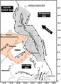
 Tectonic setting map of Sumatra.jpg 1,269 × 1,522; 460 KB
-
 Tektonische Situation um die Scotia-Platte.png 1,191 × 664; 480 KB
-
 Tibet-indonesia.png 1,000 × 578; 1.18 MB
-
 Updated lwandle.jpg 569 × 753; 629 KB
-
 Wiki cw 1.png 1,226 × 923; 72 KB
-
 Zagros Fold Belt.jpg 3,024 × 4,032; 3.29 MB


.png)


.jpg)


