Category:Table Mountain (Skamania County, Washington)
Jump to navigation
Jump to search
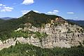
English: Table Mountain is a peak rising on the north side of the Columbia River in the US state of Washington, about four miles (6 km) north-northwest of Bonneville Dam. It is one of the most spectacular landmarks of the Columbia River Gorge. Its southeast face drops 2,400 ft (730 m) in less than one horizontal mile, and is topped by an almost vertical cliff. Table Mountain is joined by the similar Greenleaf Peak to the northeast, and also by Hamilton Mountain to the southwest, which is lower (2,438 ft/743 m), but similarly steep and much closer to the Columbia. Together these peaks form an impressive group on the Washington side of the Gorge.
Pages in category "Table Mountain (Skamania County, Washington)"
This category contains only the following page.
Media in category "Table Mountain (Skamania County, Washington)"
The following 22 files are in this category, out of 22 total.
-

-
 08353-Oregon-1906-Columbia River and Table Mountain-Brück & Sohn Kunstverlag.jpg 1,514 × 1,000; 543 KB
-
 Greenleaf Peak, Washington.jpg 5,472 × 3,648; 10.14 MB
-
 Pandion haliaetus 2352.JPG 4,272 × 2,848; 3.77 MB
-
 Pandion haliaetus 2353.JPG 4,272 × 2,848; 3.83 MB
-
 Pandion haliaetus 2354.JPG 4,272 × 2,848; 3.88 MB
-
 Skier approaching Table Mountain summit (509744015).jpg 765 × 587; 278 KB
-

-
 Table Mountain 2368.JPG 4,272 × 2,848; 4.94 MB
-
 Table Mountain 2368s.JPG 6,335 × 4,751; 6.59 MB
-
 Table Mountain 2371.JPG 4,272 × 2,848; 4.57 MB
-
 Table Mountain 2593.JPG 4,272 × 2,848; 4.75 MB
-
 Table Mountain 2595.JPG 4,272 × 2,848; 5.35 MB
-
 Table Mountain 2634.JPG 4,272 × 2,848; 4.72 MB
-
 Table Mountain 2634s.JPG 7,829 × 7,277; 10.18 MB
-
 Table Mountain 2640.JPG 4,272 × 2,848; 4.21 MB
-
 Table Mtn - Red Bluff 3545 3540.jpg 4,591 × 1,535; 3.82 MB
-
 Table Mtn - Red Bluff 3545 3544.jpg 4,608 × 2,592; 2.87 MB
-
 Table Mtn 3545.jpg 4,608 × 3,072; 3.45 MB
-

-

-

.jpg)


.jpg)
.jpg)


.jpg)
.jpg)
.jpg)