Category:Stow, Scottish Borders (civil parish)
Jump to navigation
Jump to search
Scottish parish in Scottish Borders, Scotland, UK | |||||
| Upload media | |||||
| Instance of | |||||
|---|---|---|---|---|---|
| Part of |
| ||||
| Named after | |||||
| Location |
| ||||
| Population |
| ||||
| Area |
| ||||
 | |||||
Subcategories
This category has the following 4 subcategories, out of 4 total.
Media in category "Stow, Scottish Borders (civil parish)"
The following 200 files are in this category, out of 917 total.
(previous page) (next page)-

-
-

-
 A bridge sign on the Borders Railway - geograph.org.uk - 4657040.jpg 640 × 526; 185 KB
-
 A broken wall in the Mid Plantation - geograph.org.uk - 3584477.jpg 640 × 480; 140 KB
-
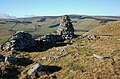
 A cairn on Crumside Hill - geograph.org.uk - 2242928.jpg 640 × 427; 167 KB
-
 A decaying tree - geograph.org.uk - 3092739.jpg 480 × 640; 285 KB
-

-

-

-
-

-

-
 A ewe and lambs on Hoppringle Hill - geograph.org.uk - 2360493.jpg 640 × 427; 161 KB
-
 A field gate at Carsinker Law - geograph.org.uk - 2085815.jpg 640 × 427; 133 KB
-
 A field of hay bales - geograph.org.uk - 6251897.jpg 1,024 × 768; 187 KB
-

-
 A ford on the Gala Water at Watherston - geograph.org.uk - 2918230.jpg 640 × 480; 196 KB
-

-

-

-
 A friendly satellite dish in Stow - geograph.org.uk - 1767605.jpg 640 × 469; 159 KB
-
 A glimpse of Long Park Wind Farm - geograph.org.uk - 5402393.jpg 3,264 × 2,448; 2.28 MB
-
 A gradient sign on the Borders Railway - geograph.org.uk - 4657044.jpg 640 × 461; 169 KB
-
 A hill fort at Carsinker Law - geograph.org.uk - 2076866.jpg 640 × 427; 130 KB
-
 A hill fort at Carsinker Law - geograph.org.uk - 2076870.jpg 640 × 427; 187 KB
-
 A house demolition at Stagebank - geograph.org.uk - 3671890.jpg 640 × 450; 159 KB
-
 A house for demolition - geograph.org.uk - 3671891.jpg 640 × 480; 186 KB
-

-

-
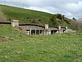
 A ruined farm building on Craigend Hill - geograph.org.uk - 1590542.jpg 640 × 396; 163 KB
-

-

-
 A sheep at Cortleferry - geograph.org.uk - 2078489.jpg 640 × 427; 139 KB
-
 A small wood, Craigend - geograph.org.uk - 3305550.jpg 640 × 480; 360 KB
-
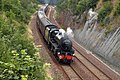
 A steam special on the Borders Railway - geograph.org.uk - 4704298.jpg 640 × 436; 173 KB
-
 A steam special on the Borders Railway - geograph.org.uk - 4704308.jpg 640 × 436; 172 KB
-
 A steam special on the Borders Railway - geograph.org.uk - 5506980.jpg 1,024 × 683; 974 KB
-

-

-
 A stubble field and bales at Cortleferry - geograph.org.uk - 2079921.jpg 640 × 421; 149 KB
-

-
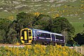
 A train on the Borders Railway - geograph.org.uk - 4801696.jpg 640 × 407; 183 KB
-
 A train on the Borders Railway - geograph.org.uk - 5019159.jpg 640 × 427; 201 KB
-
 A train on the Borders Railway - geograph.org.uk - 5951056.jpg 1,024 × 691; 665 KB
-

-
 A view over the Cockholm Burn - geograph.org.uk - 3303563.jpg 640 × 360; 203 KB
-

-
-
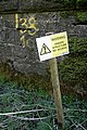 A warning sign before Bowshank Tunnel - geograph.org.uk - 1239002.jpg 427 × 640; 111 KB
-
 A wet reentrant - geograph.org.uk - 2157951.jpg 640 × 359; 74 KB
-
 A woodland's corner - geograph.org.uk - 2785729.jpg 640 × 360; 215 KB
-
 A7 - geograph.org.uk - 6427830.jpg 1,024 × 683; 373 KB
-
 A7 lay-by - geograph.org.uk - 4718781.jpg 640 × 480; 55 KB
-
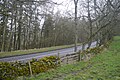
 A7 south of Heriot - geograph.org.uk - 3716496.jpg 640 × 480; 300 KB
-
 A7 Torquhan - geograph.org.uk - 4978524.jpg 1,024 × 683; 374 KB
-
 A7, Burnhouse - geograph.org.uk - 5126325.jpg 1,024 × 683; 380 KB
-
 A7, Caitha - geograph.org.uk - 5585770.jpg 1,024 × 683; 332 KB
-
 A7, Ferniehurst - geograph.org.uk - 5585784.jpg 1,024 × 683; 302 KB
-
 Above the Calfhope Burn - geograph.org.uk - 2257755.jpg 640 × 359; 79 KB
-
 Access point for the Borders Railway - geograph.org.uk - 4256696.jpg 1,024 × 678; 214 KB
-
 Access to the Borders Railway - geograph.org.uk - 4066633.jpg 3,264 × 2,448; 2.52 MB
-
 Access track - geograph.org.uk - 401716.jpg 640 × 480; 92 KB
-
 Alders by the Cockholm Burn at Cathpair - geograph.org.uk - 5402472.jpg 3,264 × 2,448; 5.91 MB
-

-
 An oddity in Burial Ground Wood, Bowland - geograph.org.uk - 3247534.jpg 640 × 480; 248 KB
-
 An old ash tree of some character - geograph.org.uk - 1238966.jpg 427 × 640; 144 KB
-

-
 An old strip wood - geograph.org.uk - 3305876.jpg 640 × 360; 253 KB
-
 An old tractor at Bowland - geograph.org.uk - 1392844.jpg 640 × 427; 141 KB
-
 An unplanted field - geograph.org.uk - 3307889.jpg 640 × 480; 272 KB
-
 An unusual plant container at Stow - geograph.org.uk - 3671867.jpg 490 × 640; 160 KB
-
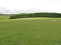
 Arable land above Stow - geograph.org.uk - 1901710.jpg 640 × 359; 48 KB
-
 Ash Alone - geograph.org.uk - 4248064.jpg 640 × 427; 404 KB
-
 Autumn lane at Townhead, Stow - geograph.org.uk - 4197687.jpg 3,264 × 2,448; 5.15 MB
-
 B6362 towards Lauder - geograph.org.uk - 5401032.jpg 640 × 470; 40 KB
-
 Bale train - geograph.org.uk - 2785903.jpg 640 × 360; 259 KB
-
 Bales and buildings at Middletoun - geograph.org.uk - 4204932.jpg 3,264 × 2,448; 4.37 MB
-
 Ballast train at Bowland Bridge - geograph.org.uk - 4326402.jpg 3,264 × 2,448; 2.8 MB
-
 Ballast train in the Gala Water valley - geograph.org.uk - 4326446.jpg 3,264 × 2,448; 4.18 MB
-
 Barley above Dryburn - geograph.org.uk - 4081299.jpg 3,264 × 2,448; 3.99 MB
-
 Barley and pasture at Bowland - geograph.org.uk - 4081628.jpg 3,264 × 2,448; 3.95 MB
-
 Beechwood, Torsonce - geograph.org.uk - 5585798.jpg 1,024 × 683; 425 KB
-
 Bench beside Craigend Road - geograph.org.uk - 3303569.jpg 640 × 360; 200 KB
-
 Bend in the B6362 towards Lauder - geograph.org.uk - 5401033.jpg 640 × 480; 42 KB
-
 Between Heriot and Fountainhall - geograph.org.uk - 5614242.jpg 2,723 × 2,040; 3.38 MB
-

-
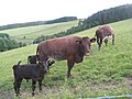
 Black cattle, Black Law - geograph.org.uk - 2120161.jpg 640 × 359; 74 KB
-
 Black Law - geograph.org.uk - 1949720.jpg 640 × 480; 82 KB
-
 Bog and ridge fence, Pringles Green - geograph.org.uk - 3938570.jpg 1,024 × 673; 177 KB
-
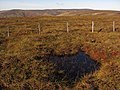
 Bog, Pringles Green - geograph.org.uk - 2120949.jpg 640 × 480; 133 KB
-
 Bog, Pringles Green - geograph.org.uk - 2256445.jpg 640 × 480; 129 KB
-
 Bogs, Caddon Head - geograph.org.uk - 2120963.jpg 640 × 480; 134 KB
-
 Border farmland from Lauder Common - geograph.org.uk - 4199439.jpg 3,264 × 2,448; 5.04 MB
-
 Border landscape - geograph.org.uk - 4066496.jpg 3,264 × 2,448; 4.32 MB
-
 Borders Line reconstruction - geograph.org.uk - 3919306.jpg 1,800 × 1,113; 1.64 MB
-
 Borders Railway - geograph.org.uk - 3716491.jpg 640 × 480; 250 KB
-
 Borders Railway - geograph.org.uk - 4978527.jpg 1,024 × 683; 308 KB
-
 Borders Railway - geograph.org.uk - 5585796.jpg 1,024 × 683; 260 KB
-
 Borders Railway - geograph.org.uk - 5587924.jpg 1,024 × 683; 285 KB
-
 Borders Railway - geograph.org.uk - 5588032.jpg 640 × 427; 44 KB
-
 Borders Railway at Killochyett - geograph.org.uk - 4256687.jpg 1,024 × 678; 221 KB
-
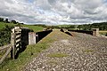
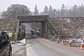 Borders Railway bridge at Bowland (1) - geograph.org.uk - 4275532.jpg 1,024 × 682; 231 KB
-
 Borders Railway bridge at Bowland (2) - geograph.org.uk - 4275537.jpg 1,024 × 682; 196 KB
-
 Borders Railway bridge near Bowshank - geograph.org.uk - 4275545.jpg 1,024 × 682; 269 KB
-
 Borders Railway construction - geograph.org.uk - 4081353.jpg 3,264 × 2,448; 2.74 MB
-
 Borders Railway Line - geograph.org.uk - 5089366.jpg 640 × 398; 85 KB
-
 Borders Railway Line At Bowland - geograph.org.uk - 5089451.jpg 640 × 405; 94 KB
-
 Borders Railway near Fountainhall - geograph.org.uk - 4064175.jpg 3,264 × 2,448; 5.86 MB
-
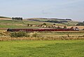
 Borders Railway south of Stow (2) - geograph.org.uk - 4257466.jpg 1,024 × 678; 163 KB
-
 Borders Railway south of Stow (2) - geograph.org.uk - 6412113.jpg 1,600 × 1,066; 526 KB
-
 Borders Railway south of Stow - geograph.org.uk - 4257435.jpg 1,024 × 678; 135 KB
-
 Borders Railway under construction - geograph.org.uk - 3714994.jpg 640 × 480; 283 KB
-
 Borders Railway under construction - geograph.org.uk - 3715038.jpg 640 × 480; 333 KB
-
 Borders Railway under construction - geograph.org.uk - 3715735.jpg 640 × 480; 276 KB
-
 Borders Railway under construction - geograph.org.uk - 3715764.jpg 640 × 480; 252 KB
-
 Borders Railway under construction - geograph.org.uk - 3777924.jpg 640 × 480; 293 KB
-
 Borders Railway under construction - geograph.org.uk - 3777928.jpg 640 × 480; 301 KB
-
 Borders Railway under construction - geograph.org.uk - 3777929.jpg 640 × 480; 324 KB
-
 Borders Railway works - geograph.org.uk - 3652667.jpg 640 × 360; 222 KB
-
 Borders Railway, Burnhouse - geograph.org.uk - 5588031.jpg 1,024 × 683; 270 KB
-
 Borders Railway, Halltree - geograph.org.uk - 5588075.jpg 1,024 × 683; 340 KB
-
 Borders Railway, Watherston - geograph.org.uk - 5587967.jpg 1,024 × 683; 320 KB
-
 Boundary wall across the Lammermuirs - geograph.org.uk - 5035644.jpg 1,024 × 682; 128 KB
-
 Bow Bridge - geograph.org.uk - 1951215.jpg 3,000 × 4,000; 4.31 MB
-
 Bow Bridge - geograph.org.uk - 3976817.jpg 640 × 420; 103 KB
-
 Bow Bridge over the Gala Water - geograph.org.uk - 4081345.jpg 3,264 × 2,448; 5.38 MB
-
 Bow Bridge Road end - geograph.org.uk - 4081363.jpg 3,188 × 2,388; 2.22 MB
-
 Bow Castle - geograph.org.uk - 1239018.jpg 640 × 427; 163 KB
-
 Bow Castle - geograph.org.uk - 2785727.jpg 640 × 360; 254 KB
-
 Bow Castle Broch - geograph.org.uk - 2264764.jpg 800 × 530; 165 KB
-
 Bow Cottages - geograph.org.uk - 3478271.jpg 640 × 480; 85 KB
-
 Bow Covert - geograph.org.uk - 1024904.jpg 640 × 359; 85 KB
-
 Bow Covert - geograph.org.uk - 5585790.jpg 1,024 × 683; 289 KB
-
 Bow Hill - geograph.org.uk - 5585775.jpg 1,024 × 683; 255 KB
-
 Bower straight - geograph.org.uk - 3715049.jpg 640 × 480; 240 KB
-
 Bowland Estate Farmland - geograph.org.uk - 5089338.jpg 640 × 402; 84 KB
-
 Bowland Farmland - geograph.org.uk - 5089334.jpg 640 × 381; 55 KB
-
 Bowland House - geograph.org.uk - 5402141.jpg 3,264 × 2,448; 2.93 MB
-
 Bowland House in summer - geograph.org.uk - 2481501.jpg 2,432 × 1,824; 916 KB
-
 Bowland railway bridge is missing - geograph.org.uk - 3649355.jpg 640 × 480; 90 KB
-
 Bowland View - geograph.org.uk - 3857885.jpg 3,448 × 4,592; 4.07 MB
-
 Bowshank Farm - geograph.org.uk - 4968692.jpg 640 × 427; 172 KB
-
 Bowshank Farm View - geograph.org.uk - 5089469.jpg 640 × 430; 78 KB
-
 Bowshank from the air - geograph.org.uk - 3596231.jpg 640 × 480; 116 KB
-
 Bowshank from the air - geograph.org.uk - 6003546.jpg 1,024 × 768; 332 KB
-
 Bowshank Tunnel - geograph.org.uk - 6427840.jpg 1,024 × 683; 178 KB
-

-
 Bracken and beech - geograph.org.uk - 4081262.jpg 3,264 × 2,448; 6.34 MB
-
 Bridge over Gala Water at Galabank - geograph.org.uk - 4545469.jpg 1,600 × 1,183; 222 KB
-
 Bridge over the Borders Railway - geograph.org.uk - 4067504.jpg 3,264 × 2,448; 3.84 MB
-
 Bridge over the Gala Water at Galabank - geograph.org.uk - 4067610.jpg 3,264 × 2,448; 3.44 MB
-
 Bridge over the Gala Water, Stow - geograph.org.uk - 4257523.jpg 1,024 × 678; 256 KB
-
 Bridge over the Waverley Line - geograph.org.uk - 4067470.jpg 3,264 × 2,448; 2.95 MB
-
 Bridge work, Borders Railway - geograph.org.uk - 3777935.jpg 640 × 480; 291 KB
-
 Brockhouse, in the Gala Water valley - geograph.org.uk - 4064182.jpg 3,264 × 2,448; 2.48 MB
-
 Building the Borders Railway - geograph.org.uk - 4067564.jpg 3,264 × 2,448; 4.81 MB
-
 Burgess Cairn, Common Riding - geograph.org.uk - 2340715.jpg 1,024 × 768; 141 KB
-
 Burial Ground Wood on the Bowland Estate - geograph.org.uk - 3247541.jpg 640 × 480; 240 KB
-
 Burnhouse Doocot - geograph.org.uk - 1238979.jpg 640 × 443; 146 KB
-
 Burnhouse Mains - geograph.org.uk - 5588025.jpg 1,024 × 683; 293 KB
-

-
 Cadams Cleugh - geograph.org.uk - 2120168.jpg 640 × 359; 83 KB
-
 Caiha Hill - geograph.org.uk - 6427874.jpg 1,024 × 683; 168 KB
-
 Cairn on Ferniehirst Hill - geograph.org.uk - 2779271.jpg 640 × 360; 219 KB
-
 Cairn, Caitha Hill - geograph.org.uk - 6427868.jpg 1,024 × 683; 214 KB
-
 Caitha Hill - geograph.org.uk - 5402424.jpg 3,264 × 2,448; 4.28 MB
-
 Caitha Hill - geograph.org.uk - 6427872.jpg 1,024 × 683; 187 KB
-
 Caitha Hill - geograph.org.uk - 6427877.jpg 1,024 × 683; 208 KB
-
 Caitha Mains - geograph.org.uk - 3857931.jpg 4,592 × 3,448; 4.47 MB
-
 Caitha Mains - geograph.org.uk - 5585779.jpg 1,024 × 683; 391 KB
-
 Calfhope Burn - geograph.org.uk - 2259924.jpg 640 × 359; 105 KB
-
 Calfhope Burn - geograph.org.uk - 2259965.jpg 640 × 359; 93 KB
-
 Canny Knowes - geograph.org.uk - 2157985.jpg 640 × 359; 109 KB
-
 Cathpair - geograph.org.uk - 2198664.jpg 640 × 480; 113 KB
-
 Cattle at Symington Mains - geograph.org.uk - 4066613.jpg 3,264 × 2,448; 3.28 MB
-
 Cattle at Watherston - geograph.org.uk - 4066516.jpg 3,264 × 2,448; 4.57 MB
-
 Cattle by the Gala Water - geograph.org.uk - 6394643.jpg 1,024 × 768; 122 KB
-
 Cattle drinking out of the Gala Water - geograph.org.uk - 3716489.jpg 640 × 480; 274 KB
-

-

-
 Cattle on Sell Moor - geograph.org.uk - 4202227.jpg 3,264 × 2,448; 4.54 MB
-
 Cattle, Rowantree Law - geograph.org.uk - 2158301.jpg 640 × 359; 89 KB
-
 Cemetery at Stow - geograph.org.uk - 4197692.jpg 3,264 × 2,448; 4.64 MB
-
 Chapel Bridge, Kilcoulter - geograph.org.uk - 6316109.jpg 1,600 × 1,060; 780 KB
-
 Chapel Hill - geograph.org.uk - 5537916.jpg 2,592 × 1,944; 1.65 MB
-
 Church of St Mary of Wedale, Stow - geograph.org.uk - 6426503.jpg 1,024 × 768; 101 KB
-
 Churches old and new at Stow - geograph.org.uk - 5537584.jpg 2,592 × 1,944; 1.23 MB
-
 Clearance cairn - geograph.org.uk - 2759172.jpg 640 × 360; 202 KB
-
 Clearance cairns, Lugate Rig - geograph.org.uk - 2785891.jpg 640 × 360; 249 KB
-
 Clearing, Little Cathpair - geograph.org.uk - 3307875.jpg 640 × 480; 235 KB
-
 Clints Hill from across the Armet Water valley - geograph.org.uk - 4200038.jpg 3,264 × 2,448; 4.02 MB
-
 Combining at Dryburn - geograph.org.uk - 5937732.jpg 1,024 × 683; 753 KB
-
 Comely Burn - geograph.org.uk - 1949745.jpg 640 × 480; 82 KB
-
 Compass Slack - geograph.org.uk - 2257756.jpg 640 × 359; 86 KB
-
 Construction base, Fountainhall - geograph.org.uk - 3715769.jpg 640 × 480; 280 KB
-
 Construction site, Fountainhall - geograph.org.uk - 3715043.jpg 640 × 480; 215 KB
-
 Cortleferry and Wedale - geograph.org.uk - 4204962.jpg 3,264 × 2,448; 3.82 MB
-
 Cortleferry Farm - geograph.org.uk - 2079926.jpg 640 × 427; 133 KB
-
 Cottage on the junction - geograph.org.uk - 976149.jpg 640 × 480; 107 KB


_-_geograph.org.uk_-_4275532.jpg)
_-_geograph.org.uk_-_4275537.jpg)


_-_geograph.org.uk_-_4257466.jpg)
_-_geograph.org.uk_-_6412113.jpg)


_-_geograph.org.uk_-_5401030.jpg)


&filefrom=Cottage%2C+Craigend+Rd%2C+Stow+-+geograph.org.uk+-+3148825.jpg#mw-category-media)