Category:Soil Conservation Service maps
Jump to navigation
Jump to search
Subcategories
This category has only the following subcategory.
Media in category "Soil Conservation Service maps"
The following 200 files are in this category, out of 276 total.
(previous page) (next page)-

-

-

-
-
 Brevard County, Florida - soil interpretive map of soil drainage and water table depths LOC 81690353.tif 5,919 × 11,453; 193.95 MB
-

-

-
 General soil map Maine LOC 90685328.jpg 5,945 × 8,691; 8.4 MB
-
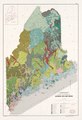 General soil map Maine LOC 90685328.tif 5,945 × 8,691; 147.82 MB
-
 General soil map of North Carolina LOC 2007629229.jpg 10,344 × 10,444; 11.16 MB
-
 General soil map of North Carolina LOC 2007629229.tif 10,344 × 10,444; 309.08 MB
-
 General soil map, Arkansas County, Arkansas LOC 83695272.jpg 5,545 × 7,167; 4.05 MB
-
 General soil map, Armstrong County, Pennsylvania LOC 81690078.jpg 3,366 × 4,846; 2.29 MB
-
 General soil map, Armstrong County, Pennsylvania LOC 81690078.tif 3,366 × 4,846; 46.67 MB
-
 General soil map, Benton County, Arkansas LOC 83693123.jpg 7,307 × 5,649; 3.95 MB
-
 General soil map, Benton County, Arkansas LOC 83693123.tif 7,307 × 5,649; 118.1 MB
-
 General soil map, Berks County, Pennsylvania LOC 92683608.jpg 5,191 × 3,384; 2.57 MB
-
 General soil map, Berks County, Pennsylvania LOC 92683608.tif 5,191 × 3,384; 50.26 MB
-
 General soil map, Bradley County, Tennessee LOC 83693504.jpg 5,324 × 3,280; 2.5 MB
-
 General soil map, Bradley County, Tennessee LOC 83693504.tif 5,324 × 3,280; 49.96 MB
-
 General soil map, Calhoun County, Arkansas LOC 83693127.jpg 5,526 × 7,146; 3.55 MB
-
 General soil map, Calhoun County, Arkansas LOC 83693127.tif 5,526 × 7,146; 112.98 MB
-
 General soil map, Carroll County, Arkansas LOC 83693128.jpg 4,840 × 3,721; 2.21 MB
-
 General soil map, Carroll County, Arkansas LOC 83693128.tif 4,840 × 3,721; 51.53 MB
-
 General soil map, Carroll County, Arkansas LOC 83693129.jpg 7,145 × 5,471; 4.17 MB
-

-

-
 General soil map, Clark County, Arkansas LOC 83693132.jpg 7,315 × 5,653; 4.89 MB
-
 General soil map, Clark County, Arkansas LOC 83693132.tif 7,315 × 5,653; 118.31 MB
-
 General soil map, Clay County, Arkansas LOC 83693130.jpg 7,318 × 5,630; 4.16 MB
-
 General soil map, Columbia County, Arkansas LOC 83693131.jpg 7,186 × 5,523; 3.97 MB
-
 General soil map, Columbia County, Arkansas LOC 83693131.tif 7,186 × 5,523; 113.55 MB
-
 General soil map, Crawford County, Arkansas LOC 83695283.jpg 7,339 × 5,648; 3.98 MB
-
 General soil map, Crawford County, Arkansas LOC 83695283.tif 7,339 × 5,648; 118.59 MB
-
 General soil map, Crittenden County, Arkansas LOC 83695281.jpg 7,233 × 5,588; 4.21 MB
-
 General soil map, Crittenden County, Arkansas LOC 83695281.tif 7,233 × 5,588; 115.64 MB
-
 General soil map, Cross County, Arkansas LOC 83693124.jpg 7,259 × 5,600; 3.95 MB
-
 General soil map, Cross County, Arkansas LOC 83693124.tif 7,259 × 5,600; 116.3 MB
-
 General soil map, District of Columbia. LOC 76697809.jpg 10,483 × 12,444; 15.59 MB
-
 General soil map, District of Columbia. LOC 76697809.tif 10,483 × 12,444; 373.22 MB
-
 General soil map, Fannin County, Georgia LOC 2012588218.jpg 5,376 × 3,268; 1.87 MB
-
 General soil map, Fannin County, Georgia LOC 2012588218.tif 5,376 × 3,268; 50.26 MB
-
 General soil map, Faulkner County, Arkansas LOC 83695282.tif 7,432 × 5,602; 119.12 MB
-
 General soil map, Franklin County, Arkansas LOC 81692332.jpg 7,232 × 5,562; 3.42 MB
-
 General soil map, Franklin County, Arkansas LOC 81692332.tif 7,232 × 5,562; 115.08 MB
-
 General soil map, Fulton County, Arkansas LOC 83695275.jpg 7,254 × 5,608; 4.13 MB
-
 General soil map, Fulton County, Arkansas LOC 83695275.tif 7,254 × 5,608; 116.39 MB
-
 General soil map, Greene County, Arkansas LOC 83695277.jpg 7,495 × 5,534; 4.08 MB
-
 General soil map, Greene County, Arkansas LOC 83695277.tif 7,495 × 5,534; 118.67 MB
-
 General soil map, Hempstead County, Arkansas LOC 81692330.jpg 7,174 × 5,520; 3.84 MB
-
 General soil map, Hempstead County, Arkansas LOC 81692330.tif 7,174 × 5,520; 113.3 MB
-
 General soil map, Howard County, Arkansas LOC 83693133.jpg 5,531 × 7,181; 3.55 MB
-
 General soil map, Johnson County, Arkansas LOC 83693134.jpg 7,172 × 5,510; 3.41 MB
-
 General soil map, Johnson County, Arkansas LOC 83693134.tif 7,172 × 5,510; 113.06 MB
-
 General soil map, Lawrence County, Arkansas LOC 83693126.jpg 7,280 × 5,614; 4.01 MB
-
 General soil map, Lawrence County, Arkansas LOC 83693126.tif 7,280 × 5,614; 116.93 MB
-
 General soil map, Lee County, Arkansas LOC 83695276.jpg 7,483 × 5,538; 4.07 MB
-
 General soil map, Lee County, Arkansas LOC 83695276.tif 7,483 × 5,538; 118.56 MB
-
 General soil map, Lincoln Parish, Louisiana LOC 92682547.jpg 6,313 × 9,210; 4.72 MB
-
 General soil map, Logan County, Arkansas LOC 83693135.jpg 7,161 × 5,493; 3.89 MB
-
 General soil map, Logan County, Arkansas LOC 83693135.tif 7,161 × 5,493; 112.54 MB
-
 General soil map, Louisiana LOC 2002626323.jpg 5,044 × 3,266; 2.05 MB
-
 General soil map, Louisiana LOC 2002626324.jpg 4,991 × 3,212; 1.9 MB
-
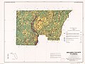
 General soil map, Marion County, Florida LOC 97687062.jpg 7,583 × 11,648; 9.89 MB
-
 General soil map, Marion County, Florida LOC 97687062.tif 7,583 × 11,648; 252.71 MB
-
 General soil map, Meigs County, Tennessee LOC 83693503.jpg 5,083 × 3,262; 2.11 MB
-
 General soil map, Meigs County, Tennessee LOC 83693503.tif 5,083 × 3,262; 47.44 MB
-
 General soil map, Miller County, Arkansas LOC 83693136.jpg 5,550 × 7,176; 4.17 MB
-
 General soil map, Miller County, Arkansas LOC 83693136.tif 5,550 × 7,176; 113.95 MB
-
 General soil map, Mississippi County, Arkansas LOC 83695280.jpg 7,470 × 5,533; 4.81 MB
-
 General soil map, Montgomery County, Arkansas LOC 83693137.jpg 7,207 × 5,498; 4.17 MB
-
 General soil map, Nevada County, Arkansas LOC 83693138.jpg 7,147 × 5,486; 3.99 MB
-
 General soil map, Nevada County, Arkansas LOC 83693138.tif 7,147 × 5,486; 112.18 MB
-
 General soil map, Newton County, Arkansas LOC 83695274.jpg 7,387 × 5,656; 4.55 MB
-
 General soil map, Newton County, Arkansas LOC 83695274.tif 7,387 × 5,656; 119.54 MB
-
 General soil map, Newton County, Georgia LOC 82693767.tif 7,379 × 5,665; 119.6 MB
-
 General soil map, Ouachita County, Arkansas LOC 83693139.jpg 7,150 × 5,493; 4.39 MB
-
 General soil map, Ouachita County, Arkansas LOC 83693139.tif 7,150 × 5,493; 112.37 MB
-
 General soil map, Pennsylvania LOC 81694489.jpg 8,823 × 6,726; 12.81 MB
-
 General soil map, Pennsylvania LOC 81694489.tif 8,823 × 6,726; 169.78 MB
-
 General soil map, Perry County, Arkansas LOC 83693140.jpg 7,299 × 5,594; 3.71 MB
-
 General soil map, Perry County, Arkansas LOC 83693140.tif 7,299 × 5,594; 116.82 MB
-
 General soil map, Phillips County, Arkansas LOC 83693122.jpg 7,308 × 5,645; 4.25 MB
-
 General soil map, Pike County, Arkansas LOC 83693141.jpg 7,270 × 5,599; 4 MB
-
 General soil map, Pike County, Arkansas LOC 83693141.tif 7,270 × 5,599; 116.46 MB
-
 General soil map, Polk County, Tennessee LOC 87693822.jpg 5,095 × 3,272; 2.16 MB
-
 General soil map, Pope County, Arkansas LOC 83693142.jpg 7,215 × 5,548; 3.87 MB
-
 General soil map, Pope County, Arkansas LOC 83693142.tif 7,215 × 5,548; 114.52 MB
-
 General soil map, Prairie County, Arkansas LOC 83693143.jpg 4,220 × 3,262; 1.42 MB
-
 General soil map, Prairie County, Arkansas LOC 83693143.tif 4,220 × 3,262; 39.38 MB
-
 General soil map, Prairie County, Arkansas LOC 83693144.jpg 7,180 × 5,497; 4 MB
-
 General soil map, Pulaski County, Arkansas LOC 83693145.tif 7,187 × 5,517; 113.44 MB
-
 General soil map, Rockdale County, Georgia LOC 82693768.jpg 7,291 × 5,669; 4.54 MB
-
 General soil map, Sabine Parish, Louisiana LOC 89695111.jpg 6,107 × 8,553; 5.55 MB
-
 General soil map, Saline County, Arkansas LOC 83693146.jpg 7,361 × 5,659; 4.47 MB
-
 General soil map, Saline County, Arkansas LOC 83693146.tif 7,361 × 5,659; 119.18 MB
-
 General soil map, Scott County, Arkansas LOC 83693147.jpg 7,335 × 5,617; 4.76 MB
-
 General soil map, Scott County, Arkansas LOC 83693147.tif 7,335 × 5,617; 117.88 MB
-
 General soil map, Scott County, Tennessee LOC 88691860.tif 7,496 × 5,703; 122.31 MB
-
 General soil map, Sebastian County, Arkansas LOC 83693148.jpg 7,350 × 5,649; 3.88 MB
-
 General soil map, Sevier County, Arkansas LOC 83693149.jpg 7,318 × 5,627; 4.3 MB
-
 General soil map, Sevier County, Arkansas LOC 83693149.tif 7,318 × 5,627; 117.81 MB
-
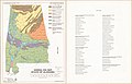 General soil map, state of Alabama LOC 90684182.jpg 5,164 × 3,335; 1.61 MB
-
 General soil map, state of Alabama LOC 90684182.tif 5,164 × 3,335; 49.27 MB
-
 General soil map, State of Alabama LOC 90684183.jpg 5,692 × 7,161; 7.01 MB
-
 General soil map, State of Alabama LOC 90684183.tif 5,692 × 7,161; 116.62 MB
-
 General soil map, Union County, Arkansas LOC 83693150.jpg 7,219 × 5,530; 4.56 MB
-
 General soil map, Union County, Arkansas LOC 83693150.tif 7,219 × 5,530; 114.22 MB
-
 General soil map, Virginia LOC 2013587390.jpg 8,944 × 9,000; 6.84 MB
-
 General soil map, Virginia LOC 2013587390.tif 8,944 × 9,000; 230.3 MB
-
 General soil map, Virginia LOC 81690105.jpg 8,269 × 8,530; 6.46 MB
-
 General soil map, Virginia LOC 81690105.tif 8,269 × 8,530; 201.8 MB
-
 General soil map, White County, Arkansas LOC 83695279.tif 7,464 × 5,524; 117.96 MB
-
 General soil map, Woodruff County, Arkansas LOC 83693125.tif 7,235 × 5,538; 114.63 MB
-
 General soil map, Yell County, Arkansas LOC 83695273.jpg 7,482 × 5,581; 4.83 MB
-
 High Plains Underground Water Conservation District No. 1, Texas LOC 92682545.jpg 3,276 × 4,170; 1.39 MB
-
 High Plains Underground Water Conservation District No. 1, Texas LOC 92682545.tif 3,276 × 4,170; 39.08 MB
-
 High Plains Underground Water Conservation District No. 1, Texas LOC 92682546.jpg 5,518 × 7,006; 4.08 MB
-
 High Plains Underground Water Conservation District No. 1, Texas LOC 92682546.tif 5,518 × 7,006; 110.6 MB
-
-

-

-
 Hydrologic soil group, Mifflin County, Pennsylvania - hydrologic soil groups LOC 87694345.tif 5,240 × 3,428; 51.39 MB
-
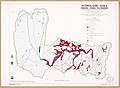 Hydrologic soils, Fishing Creek watershed, Frederick County, Maryland LOC 92683638.jpg 6,721 × 4,950; 3.66 MB
-

-
 Location, Fishing Creek watershed, Frederick County, Maryland LOC 92683651.jpg 2,652 × 3,373; 1.53 MB
-
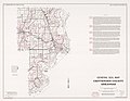
 Maine, soil and water conservation districts LOC 81690088.jpg 5,066 × 6,610; 5.56 MB
-
 Maine, soil and water conservation districts LOC 81690088.tif 5,066 × 6,610; 95.81 MB
-
 Maine, Soil Conservation Service administrative map - January 1991 LOC 92683203.jpg 2,538 × 3,295; 1.11 MB
-
 Maine, Soil Conservation Service administrative map - January 1991 LOC 92683203.tif 2,538 × 3,295; 23.93 MB
-
 Maine, Soil Conservation Service administrative map LOC 81693329.jpg 2,545 × 3,299; 1.08 MB
-
 Maine, Soil Conservation Service administrative map LOC 81693329.tif 2,545 × 3,299; 24.02 MB
-

-

-
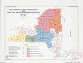
 Map of Alabama showing soil and water conservation district organization. LOC gm69002242.jpg 3,644 × 5,590; 1.85 MB
-
 Map of Alabama showing soil and water conservation district organization. LOC gm69002242.tif 3,644 × 5,590; 58.28 MB
-

-

-
 Pennsylvania, U.S.D.A. Soil Conservation Service administrative areas LOC 92683611.jpg 3,287 × 2,542; 1.08 MB
-
 Pennsylvania, U.S.D.A. Soil Conservation Service administrative areas LOC 92683611.tif 3,287 × 2,542; 23.91 MB
-
 Pennsylvania, U.S.D.A. Soil Conservation Service administrative areas LOC 92683612.jpg 3,274 × 2,492; 1.14 MB
-
 Pennsylvania, U.S.D.A. Soil Conservation Service administrative areas LOC 92683612.tif 3,274 × 2,492; 23.34 MB
-
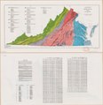
 Physiography, drainage, and geology of Door County, Wisconsin 1978.tif 2,229 × 1,203; 1.19 MB
-

-

-
 Prime farmland of New York LOC 81693112.jpg 11,926 × 8,881; 13.37 MB
-
 Prime farmland, state of Texas LOC 82692886.jpg 3,131 × 2,379; 745 KB
-
 Reconnaissance erosion survey of the state of California - btv1b53189493n.jpg 12,150 × 13,926; 16.34 MB
-
 Reconnaissance erosion survey of the State of Georgia - btv1b53189481b.jpg 12,408 × 14,236; 19.04 MB
-
 Reconnaissance erosion survey of the State of Louisiana - btv1b531894837.jpg 13,530 × 12,436; 17.08 MB
-
 Reconnaissance erosion survey of the State of Michigan - btv1b53189484p.jpg 8,568 × 9,948; 7.74 MB
-
 Reconnaissance erosion survey of the State of Minnesota - btv1b53189488g.jpg 8,000 × 8,886; 8.83 MB
-
 Reconnaissance erosion survey of the State of Nebraska - btv1b531894926.jpg 10,418 × 5,346; 7.13 MB
-
 Reconnaissance erosion survey of the State of New Jersey - btv1b53189489x.jpg 4,860 × 10,604; 4.31 MB
-
 Reconnaissance erosion survey of the State of New-York - btv1b531894909.jpg 14,791 × 11,996; 19.71 MB
-
 Reconnaissance erosion survey of the State of North Carolina - btv1b53189491r.jpg 16,641 × 8,875; 17.64 MB
-
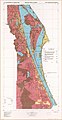
 Reconnaissance erosion survey of the State of Virginia - btv1b53189482s.jpg 16,624 × 9,475; 16.81 MB
-
 Reconnaissance erosion survey of the States of Maryland and Delaware - btv1b53189486k.jpg 10,720 × 6,494; 5.99 MB
-

-
 Reconnaissance erosion survey of the States of New-Hampshire and Vermont - btv1b531894871.jpg 7,056 × 10,008; 6.69 MB
-

-

-
 Soil and water conservation districts, Louisiana LOC 92682937.jpg 2,491 × 3,267; 718 KB
-
 Soil areas of Alabama LOC 2001624637.jpg 5,162 × 3,331; 2.22 MB
-
 Soil areas of Alabama LOC 2001624637.tif 5,162 × 3,331; 49.19 MB
-
 Soil areas of Alabama LOC 90684181.jpg 5,175 × 3,335; 2.13 MB
-
 Soil areas of Alabama LOC 90684181.tif 5,175 × 3,335; 49.38 MB
-
-

-

-

-

-
-

-
 Soil Map, Kiowa County, Oklahoma LOC 2010587906.jpg 13,583 × 11,735; 16.63 MB
-

-

-

-
 Soil survey area status map, as of December 31, 1980, New Hampshire LOC 81692784.jpg 5,053 × 7,487; 4.4 MB
-
 Soil survey area status map, as of December 31, 1980, New Hampshire LOC 81692784.tif 5,053 × 7,487; 108.24 MB
-
 Soil survey, status of mapping, 1-1-82 - Texas LOC 85692451.jpg 2,546 × 3,281; 667 KB
-
 Soil survey, status of mapping, 1-1-82 - Texas LOC 85692451.tif 2,546 × 3,281; 23.9 MB
-
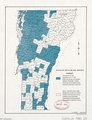
 Status of detailed soil surveys, Vermont - October 1, 1994 LOC 2002621256.jpg 2,499 × 3,265; 1.23 MB
-
 Status of detailed soil surveys, Vermont - October 1, 1994 LOC 2002621256.tif 2,499 × 3,265; 23.34 MB
-
 Status of detailed soil surveys, Vermont. LOC 81690085.jpg 2,524 × 3,292; 1.27 MB
-
 Status of detailed soil surveys, Vermont. LOC 81690085.tif 2,524 × 3,292; 23.77 MB
-
 Status of detailed soil surveys, Vermont. LOC 82690887.jpg 2,508 × 3,262; 1.04 MB
-
 Status of detailed soil surveys, Vermont. LOC 82690887.tif 2,508 × 3,262; 23.41 MB
-
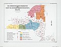
 Status of New York soil surveys - October 1, 1980 LOC 81690084.jpg 3,278 × 2,515; 983 KB
-
 Status of New York soil surveys - October 1, 1980 LOC 81690084.tif 3,278 × 2,515; 23.59 MB
-
 Status of New York soil surveys - October 1, 1981 LOC 82690611.jpg 3,298 × 2,540; 1.01 MB
-
 Status of New York soil surveys - October 1, 1981 LOC 82690611.tif 3,298 × 2,540; 23.97 MB
-
 Status of soil survey digitizing, North Carolina - October 1995 LOC 2007627687.jpg 4,073 × 3,318; 1.21 MB
-
 Status of soil survey digitizing, North Carolina - October 1995 LOC 2007627687.tif 4,073 × 3,318; 38.66 MB
-
 Status of soil surveys as of January 1, 1980 - (Massachusetts) LOC 81690114.jpg 4,754 × 3,138; 1.75 MB
-
 Status of soil surveys as of January 1, 1980 - (Massachusetts) LOC 81690114.tif 4,754 × 3,138; 42.68 MB
-
 Status of soil surveys as of January 1, 1982 - Massachusetts LOC 82696201.jpg 5,073 × 3,294; 2.03 MB
-
 Status of soil surveys as of January 1, 1982 - Massachusetts LOC 82696201.tif 5,073 × 3,294; 47.81 MB
-
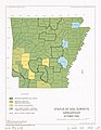 Status of soil surveys, Arkansas - October 1995 LOC 2013592238.jpg 2,540 × 3,284; 831 KB
-
 Status of soil surveys, Arkansas - October 1995 LOC 2013592238.tif 2,540 × 3,284; 23.87 MB


_LOC_95686005.jpg)


_LOC_81690114.jpg)

