Category:Sionsite (Lier)
Jump to navigation
Jump to search
| Object location | | View all coordinates using: OpenStreetMap |
|---|
Lier | |||||
| Upload media | |||||
| Instance of | |||||
|---|---|---|---|---|---|
| Location | Lier, Arrondissement of Mechelen, Province of Antwerp, Flemish Region, Belgium | ||||
 | |||||
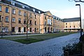
Nederlands: De Sionsite is een stadsontwikkelingsproject in Lier. De site omvat de Sionsvest, het Sionsplein, de Koepoortstraat, de P.J. Denisstraat en de Van Grasenstraat.
English: Sionsite is an urban development project in Lier. De site comprises 5 streets: Sionsvest, Sionsplein, Koepoortstraat, P.J. Denisstraat and Van Grasenstraat.
Media in category "Sionsite (Lier)"
The following 4 files are in this category, out of 4 total.
-
 SASK in Sionsite 1.jpg 6,000 × 4,000; 7.02 MB
-
 SASK in Sionsite 2.jpg 6,000 × 4,000; 5.88 MB
-
 Sion Lier Appartementen 1.jpg 6,000 × 4,000; 6.8 MB
-
 Sionsite SASK.jpg 6,000 × 4,000; 6.58 MB


