Category:Sionbrug (Lier)
Jump to navigation
Jump to search
| Object location | | View all coordinates using: OpenStreetMap |
|---|
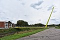
bikeway bridge in Lier (Belgium) | |||||
| Upload media | |||||
| Instance of | |||||
|---|---|---|---|---|---|
| Location | Lier, Arrondissement of Mechelen, Province of Antwerp, Flemish Region, Belgium | ||||
| Crosses | |||||
 | |||||
Media in category "Sionbrug (Lier)"
The following 7 files are in this category, out of 7 total.
-
 Fietsbrug Sion (noord).jpg 6,000 × 4,000; 7.02 MB
-
 Fietsbrug Sion (noord-stadsvest).jpg 6,000 × 4,000; 7.08 MB
-
 Fietsbrug Sion (oost).jpg 6,000 × 4,000; 7.67 MB
-
 Fietsbrug Sion (west).jpg 6,000 × 4,000; 6.92 MB
-
 Sion bridge in Lier.jpg 5,340 × 3,634; 5.76 MB
-
 Sionsite in opbouw Fietsersbrug.jpg 6,000 × 4,000; 7.33 MB
-
 Sionsite in opbouw.jpg 6,000 × 4,000; 6.97 MB
.jpg)
.jpg)
.jpg)
.jpg)


