Category:Satellite pictures of volcanoes in Canada
Jump to navigation
Jump to search
Countries of the Americas: Argentina · Bolivia · Canada · Chile · Colombia · Costa Rica · Ecuador · El Salvador · Guatemala · Mexico · Nicaragua · Peru · United States of America
Subcategories
This category has only the following subcategory.
Media in category "Satellite pictures of volcanoes in Canada"
The following 11 files are in this category, out of 11 total.
-
 Big Raven Plateau.jpg 372 × 520; 64 KB
-
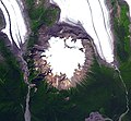 Hoodoo Mountain satellite.jpg 772 × 716; 110 KB
-
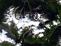
 Hoodoo Mountain satellite2.jpg 438 × 415; 21 KB
-
 Ilgachuz Range.jpg 702 × 626; 143 KB
-
 Mount Cayley ASTER 2012-05-03.jpg 3,721 × 6,384; 2.16 MB
-
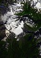
 Mount Edziza satellite.jpg 1,476 × 2,020; 580 KB
-
 Mount Garibaldi ASTER 2010-09-03(2).jpg 846 × 1,532; 385 KB
-
 Mount Garibaldi ASTER 2010-09-03.jpg 1,378 × 1,927; 445 KB
-
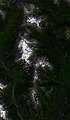
 Mount Meager satellite.jpg 1,278 × 954; 253 KB
-
 RainbowIlgachuzItcha.jpg 510 × 207; 17 KB
-
 Salal Glacier volcano.jpg 1,110 × 718; 612 KB


.jpg)


