Category:Satellite pictures of the Auckland Region
Jump to navigation
Jump to search
Subcategories
This category has only the following subcategory.
A
Media in category "Satellite pictures of the Auckland Region"
The following 22 files are in this category, out of 22 total.
-
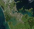 Auckland.arp.750pix (cropped).jpg 323 × 279; 17 KB
-
 Auckland.arp.750pix.jpg 1,144 × 988; 147 KB
-
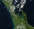
 Coromandel.arp.375pix.jpg 570 × 404; 38 KB
-
-
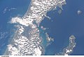 ISS008-E-6609 - View of the North Island of New Zealand.jpg 3,032 × 2,064; 975 KB
-
 ISS008-E-6610 - View of the North Island of New Zealand.jpg 3,032 × 2,064; 961 KB
-
 ISS008-E-6611 - View of the North Island of New Zealand.jpg 3,032 × 2,064; 822 KB
-
 ISS008-E-6612 - View of the North Island of New Zealand.jpg 3,032 × 2,064; 810 KB
-
 ISS008-E-6613 - View of the North Island of New Zealand.jpg 3,032 × 2,064; 833 KB
-
 ISS008-E-6614 - View of the North Island of New Zealand.jpg 3,032 × 2,064; 737 KB
-
 ISS008-E-6615 - View of the North Island of New Zealand.jpg 3,032 × 2,064; 534 KB
-
 ISS008-E-6616 - View of the North Island of New Zealand.jpg 3,032 × 2,064; 593 KB
-
 ISS008-E-6617 - View of the North Island of New Zealand.jpg 3,032 × 2,064; 368 KB
-
 ISS008-E-6618 - View of the North Island of New Zealand.jpg 3,032 × 2,064; 631 KB
-

-
 ISS008-E-6619 - View of the North Island of New Zealand.jpg 3,032 × 2,064; 718 KB
-
 ISS008-E-6620 - View of the North Island of New Zealand.jpg 3,032 × 2,064; 457 KB
-
 ISS022-E-72458 - View of the North Island of New Zealand.jpg 4,288 × 2,848; 1.34 MB
-
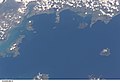
 Manukau Harbour (satellite image).jpg 2,048 × 1,536; 2.43 MB
-
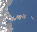
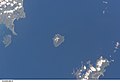
 Motuihe Island.jpg 536 × 384; 51 KB
-
 Northland Peninsula.png 992 × 653; 420 KB
-
 WaihekeIsland.png 1,152 × 784; 829 KB
.jpg)


.jpg)


.jpg)


.jpg)


