Category:Satellite pictures of Auckland
Jump to navigation
Jump to search
Media in category "Satellite pictures of Auckland"
The following 39 files are in this category, out of 39 total.
-
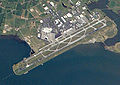 Auckland international airport from space.jpg 700 × 496; 275 KB
-
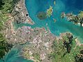
 Auckland isthmus and Waitemata Harbour.jpg 2,074 × 1,769; 2.08 MB
-
 Auckland isthmus.arp.375pix (cropped).jpg 323 × 229; 14 KB
-
 Auckland, New Zealand by Planet Labs (cropped to North Shore).jpg 2,893 × 3,050; 3.79 MB
-
 Auckland, New Zealand by Planet Labs (cropped to Waitemata harbour).jpg 4,893 × 5,444; 12.08 MB
-
 Auckland, New Zealand by Planet Labs (cropped).jpg 2,352 × 2,520; 2.33 MB
-
 Auckland, New Zealand by Planet Labs (Greenhithe).jpg 1,137 × 853; 473 KB
-
 Auckland, New Zealand by Planet Labs (Oruamo or Hellyers Creek).jpg 1,109 × 1,000; 556 KB
-
 Auckland, New Zealand by Planet Labs (Pohutukawa Coast).jpg 2,798 × 2,008; 1.99 MB
-
 Auckland, New Zealand by Planet Labs (Rangitoto Channel).jpg 4,044 × 3,033; 4.49 MB
-
 Auckland, New Zealand by Planet Labs (Wairopa Channel).jpg 2,105 × 2,296; 1.79 MB
-
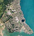
 Auckland, New Zealand by Planet Labs (West Auckland).jpg 2,137 × 5,100; 4.89 MB
-
 Auckland, New Zealand by Planet Labs (Whau River).jpg 877 × 2,092; 852 KB
-
 Auckland, New Zealand by Planet Labs.jpg 9,676 × 7,257; 29.88 MB
-
 Auckland, New Zealand ESA23778751.png 1,400 × 1,050; 1.42 MB
-
 Auckland20061016222837 (cropped).jpg 2,151 × 1,526; 1.43 MB
-
 Auckland20061016222837 (Huia Bank).jpg 410 × 350; 60 KB
-
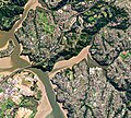
 Auckland20061016222837 (Papakura Channel).jpg 1,998 × 574; 504 KB
-
 Auckland20061016222837 (Pūrākau Channel).jpg 1,055 × 870; 381 KB
-
 Auckland20061016222837 (South Auckland).jpg 1,789 × 1,259; 1.25 MB
-
 Auckland20061016222837 (Waiuku Channel).jpg 661 × 1,308; 409 KB
-
 Auckland20061016222837.jpg 5,599 × 4,983; 10.15 MB
-
 CBD Tunnel Landsat 7 Image Auckland.jpg 1,000 × 660; 160 KB
-
 Central Connector Landsat 7 Image Auckland.jpg 1,000 × 660; 162 KB
-
 East Coast Bays, Auckland, New Zealand (ISS016-E-14040).jpg 3,032 × 2,008; 1.1 MB
-
 East Coast Bays, Auckland, New Zealand (ISS016-E-14041).jpg 3,032 × 2,008; 1.03 MB
-
Google Timelapse- Auckland, New Zealand.webm 12 s, 3,840 × 2,160; 28.29 MB
-
 ISS018-E-11081 - Auckland and Riverhead Forest.jpg 656 × 574; 374 KB
-
 ISS061-E-52745 - View of Earth - cropped.jpg 1,952 × 1,276; 1.23 MB
-
 ISS061-E-52745 - View of Earth.jpg 5,568 × 3,712; 2.09 MB
-
 Lake Pupuke - satellite photo.jpg 157 × 203; 23 KB
-
 Mangere Bridge and Puketutu ISS005-E-16872.jpg 1,007 × 838; 269 KB
-
 Maungataketake by by Planet Labs.jpg 662 × 504; 123 KB
-
 Maungataketake by by Planet Labs.png 550 × 419; 693 KB
-
 Upper Waitemata Harbour.jpg 780 × 665; 340 KB
-
 Waterview Connection Indicative Map.jpg 880 × 600; 429 KB
-
 Western Waterfront Auckland.jpg 1,200 × 800; 289 KB
-
 Western Waterfront Wynyard Crossing.jpg 1,200 × 800; 142 KB
-
 Ōrākei, Auckland, New Zealand (CAPELLA C09 SM GEO HH 20231224140355 20231224140359).tiff 27,332 × 22,237, 6 pages; 294.26 MB


.jpg)
.jpg)
.jpg)
.jpg)
.jpg)
.jpg)
.jpg)
.jpg)
.jpg)
.jpg)
.jpg)


.jpg)
.jpg)
.jpg)
.jpg)
.jpg)


.jpg)
.jpg)


.jpg)