Category:SVG topographic maps of Iran
Jump to navigation
Jump to search
Countries of Asia: Afghanistan · Armenia‡ · Azerbaijan‡ · Bangladesh · Bhutan · Brunei · Cambodia · People's Republic of China · Cyprus‡ · East Timor · Egypt‡ · Georgia‡ · India · Indonesia‡ · Iran · Iraq · Israel · Japan · Jordan · Kazakhstan‡ · Kuwait · Kyrgyzstan · Laos · Lebanon · Malaysia · Mongolia · Myanmar · Nepal · North Korea · Oman · Pakistan · Philippines · Qatar · Russia‡ · Saudi Arabia · Singapore · South Korea · Sri Lanka · Syria · Tajikistan · Thailand · Turkey‡ · Turkmenistan · Uzbekistan · Vietnam · Yemen
‡: partly located in Asia
‡: partly located in Asia
Media in category "SVG topographic maps of Iran"
The following 11 files are in this category, out of 11 total.
-
 CordilleraCentralIraní.svg 717 × 658; 23.54 MB
-
 Goreh-Jask Pipeline.svg 1,747 × 1,088; 2.21 MB
-
 Ilam Relief Location Map.svg 678 × 678; 7.3 MB
-
 Iran nuclear program map-fr.svg 1,440 × 1,071; 376 KB
-
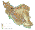
 Iran-geographic map clean.svg 3,013 × 2,600; 8.62 MB
-
 Iran-geographic map-es.svg 3,013 × 2,600; 14.13 MB
-
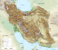 Iran-geographic map.svg 3,013 × 2,600; 12.7 MB
-
 Map Iran railways es.svg 2,318 × 2,000; 7.52 MB
-
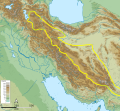
 MontesZagros.svg 717 × 658; 23.53 MB
-
 PenínsulaArábigaTopográfico.svg 795 × 618; 21.41 MB
-
 ZagrosV2 1PolSimp.svg 1,502 × 1,239; 5.81 MB


