Category:SVG maps of municipalities of Cantabria
Jump to navigation
Jump to search
Provinces of Spain: Álava · Balearic Islands‡ · Cantabria‡ · Gipuzkoa · Guadalajara · Madrid‡ · Navarre‡ · Autonomous cities:
‡: uniprovincial autonomous communities.
‡: uniprovincial autonomous communities.
Autonomous communities of Spain: Balearic Islands · Cantabria · Catalonia · Community of Madrid · Navarre · Autonomous cities:
Media in category "SVG maps of municipalities of Cantabria"
The following 107 files are in this category, out of 107 total.
-
 Municipios (Cantabria) Mapa.svg 512 × 365; 89 KB
-
 Alfoz de Lloredo (Cantabria) Mapa.svg 675 × 425; 129 KB
-
 Ampuero (Cantabria) Mapa.svg 675 × 425; 128 KB
-
 Anievas (Cantabria) Mapa.svg 675 × 425; 128 KB
-
 Arenas de Iguña (Cantabria) Mapa.svg 675 × 425; 128 KB
-
 Argoños (Cantabria) Mapa.svg 675 × 425; 129 KB
-
 Arnuero (Cantabria) Mapa.svg 675 × 425; 129 KB
-
 Arredondo (Cantabria) Mapa.svg 675 × 425; 128 KB
-
 Bahía de Santander (Cantabria) Mapa.svg 675 × 425; 129 KB
-
 Bareyo (Cantabria) Mapa.svg 675 × 425; 129 KB
-
 Bárcena de Cicero (Cantabria) Mapa.svg 675 × 425; 129 KB
-
 Bárcena de Pie de Concha (Cantabria) Mapa.svg 675 × 425; 128 KB
-
 Cabezón de la Sal (Cantabria) Mapa.svg 675 × 425; 128 KB
-
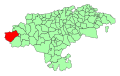
 Cabezón de Liébana (Cantabria) Mapa.svg 675 × 425; 128 KB
-
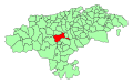
 Cabuérniga (Cantabria) Mapa.svg 675 × 425; 128 KB
-
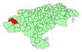
 Camaleño (Cantabria) Mapa.svg 675 × 425; 128 KB
-
 Camargo (Cantabria) Mapa.svg 675 × 425; 129 KB
-
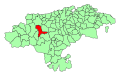
 Campoo - Cabuérniga (Cantabria) Mapa.svg 675 × 425; 128 KB
-
 Campoo de Enmedio (Cantabria) Mapa.svg 675 × 425; 128 KB
-
 Campoo de Yuso (Cantabria) Mapa.svg 675 × 425; 128 KB
-
 Cantabria-loc.svg 512 × 365; 190 KB
-
 Spain Cantabria location map.svg 512 × 364; 168 KB
-
 Cantabria - Mapa municipal.svg 778 × 413; 206 KB
-
 Cartes (Cantabria) Mapa.svg 675 × 425; 128 KB
-
 Castañeda (Cantabria) Mapa.svg 675 × 425; 128 KB
-
 Castro Urdiales (Cantabria) Mapa.svg 675 × 425; 129 KB
-
 Cieza (Cantabria) Mapa.svg 675 × 425; 128 KB
-
 Cillorigo de Liébana (Cantabria) Mapa.svg 675 × 425; 128 KB
-
 Colindres (Cantabria) Mapa.svg 675 × 425; 129 KB
-
 Comillas (Cantabria) Mapa.svg 675 × 425; 129 KB
-
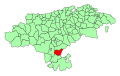
 Corvera de Toranzo (Cantabria) Mapa.svg 675 × 425; 128 KB
-
 El Astillero (Cantabria) Mapa.svg 675 × 425; 129 KB
-
 Entrambasaguas (Cantabria) Mapa.svg 675 × 425; 128 KB
-
 Escalante (Cantabria) Mapa.svg 675 × 425; 129 KB
-
 Guriezo (Cantabria) Mapa.svg 675 × 425; 128 KB
-
 Hazas de Cesto (Cantabria) Mapa.svg 675 × 425; 129 KB
-
 Hermandad de Campoo de Suso (Cantabria) Mapa.svg 675 × 425; 128 KB
-
 Herrerías (Cantabria) Mapa.svg 675 × 425; 129 KB
-
 Lamasón (Cantabria) Mapa.svg 675 × 425; 128 KB
-
 Laredo (Cantabria) Mapa.svg 675 × 425; 129 KB
-
 Las Rozas de Valdearroyo (Cantabria) Mapa.svg 675 × 425; 128 KB
-
 Liendo (Cantabria) Mapa.svg 675 × 425; 129 KB
-
 Limpias (Cantabria) Mapa.svg 675 × 425; 129 KB
-
 Liérganes (Cantabria) Mapa.svg 675 × 425; 128 KB
-
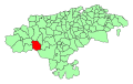
 Los Corrales de Buelna (Cantabria) Mapa.svg 675 × 425; 128 KB
-
 Los Tojos (Cantabria) Mapa.svg 675 × 425; 128 KB
-
 Luena (Cantabria) Mapa.svg 675 × 425; 128 KB
-
 Marina de Cudeyo (Cantabria) Mapa.svg 675 × 425; 129 KB
-
 Mazcuerras (Cantabria) Mapa.svg 675 × 425; 128 KB
-
 Medio Cudeyo (Cantabria) Mapa.svg 675 × 425; 129 KB
-
 Meruelo (Cantabria) Mapa.svg 675 × 425; 129 KB
-
 Miengo (Cantabria) Mapa.svg 675 × 425; 129 KB
-
 Miera (Cantabria) Mapa.svg 675 × 425; 128 KB
-
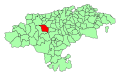
 Molledo (Cantabria) Mapa.svg 675 × 425; 128 KB
-
 Noja (Cantabria) Mapa.svg 675 × 425; 129 KB
-
 Penagos (Cantabria) Mapa.svg 675 × 425; 128 KB
-
 Pesaguero (Cantabria) Mapa.svg 675 × 425; 128 KB
-
 Pesquera (Cantabria) Mapa.svg 675 × 425; 128 KB
-
 Peñarrubia (Cantabria) Mapa.svg 675 × 425; 128 KB
-
 Piélagos (Cantabria) Mapa.svg 675 × 425; 129 KB
-
 Polaciones (Cantabria) Mapa.svg 675 × 425; 128 KB
-
 Polanco (Cantabria) Mapa.svg 675 × 425; 129 KB
-
 Puente Viesgo (Cantabria) Mapa.svg 675 × 425; 128 KB
-
 Ramales de la Victoria (Cantabria) Mapa.svg 675 × 425; 128 KB
-
 Rasines (Cantabria) Mapa.svg 675 × 425; 128 KB
-
 Reinosa (Cantabria) Mapa.svg 675 × 425; 128 KB
-
 Reocín (Cantabria) Mapa.svg 675 × 425; 129 KB
-
 Ribamontán al Mar (Cantabria) Mapa.svg 675 × 425; 129 KB
-
 Ribamontán al Monte (Cantabria) Mapa.svg 675 × 425; 129 KB
-
 Rionansa (Cantabria) Mapa.svg 675 × 425; 128 KB
-
 Riotuerto (Cantabria) Mapa.svg 675 × 425; 128 KB
-
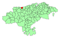
 Ruente (Cantabria) Mapa.svg 675 × 425; 128 KB
-
 Ruesga (Cantabria) Mapa.svg 675 × 425; 128 KB
-
 Ruiloba (Cantabria) Mapa.svg 675 × 425; 129 KB
-
 San Felices de Buelna (Cantabria) Mapa.svg 675 × 425; 128 KB
-
 San Miguel de Aguayo (Cantabria) Mapa.svg 675 × 425; 128 KB
-
 San Pedro del Romeral (Cantabria) Mapa.svg 675 × 425; 128 KB
-
 San Roque de Riomiera (Cantabria) Mapa.svg 675 × 425; 128 KB
-
 San Vicente de la Barquera (Cantabria) Mapa.svg 675 × 425; 129 KB
-
 Santa Cruz de Bezana (Cantabria) Mapa.svg 675 × 425; 129 KB
-
 Santa María de Cayón (Cantabria) Mapa.svg 675 × 425; 128 KB
-
 Santander (Cantabria) Mapa.svg 675 × 425; 129 KB
-
 Santillana del Mar (Cantabria) Mapa.svg 675 × 425; 129 KB
-
 Santiurde de Reinosa (Cantabria) Mapa.svg 675 × 425; 128 KB
-
 Santiurde de Toranzo (Cantabria) Mapa.svg 675 × 425; 128 KB
-
 Santoña (Cantabria) Mapa.svg 675 × 425; 129 KB
-
 Saro (Cantabria) Mapa.svg 675 × 425; 128 KB
-
 Selaya (Cantabria) Mapa.svg 675 × 425; 128 KB
-
 Soba (Cantabria) Mapa.svg 675 × 425; 128 KB
-
 Solórzano (Cantabria) Mapa.svg 675 × 425; 128 KB
-
 Suances (Cantabria) Mapa.svg 675 × 425; 129 KB
-
 Torrelavega (Cantabria) Mapa.svg 675 × 425; 128 KB
-
 Tresviso (Cantabria) Mapa.svg 675 × 425; 128 KB
-
 Tudanca (Cantabria) Mapa.svg 675 × 425; 128 KB
-
 Udías (Cantabria) Mapa.svg 675 × 425; 129 KB
-
 Val de San Vicente (Cantabria) Mapa.svg 675 × 425; 129 KB
-
 Valdeolea (Cantabria) Mapa.svg 675 × 425; 128 KB
-
 Valdeprado del Río (Cantabria) Mapa.svg 675 × 425; 128 KB
-
 Valderredible (Cantabria) Mapa.svg 675 × 425; 128 KB
-
 Valdáliga (Cantabria) Mapa.svg 675 × 425; 129 KB
-
 Valle de Villaverde (Cantabria) Mapa.svg 675 × 425; 128 KB
-
 Vega de Liébana (Cantabria) Mapa.svg 675 × 425; 128 KB
-
 Vega de Pas (Cantabria) Mapa.svg 675 × 425; 128 KB
-
 Villacarriedo (Cantabria) Mapa.svg 675 × 425; 128 KB
-
 Villaescusa (Cantabria) Mapa.svg 675 × 425; 128 KB
-
 Villafufre (Cantabria) Mapa.svg 675 × 425; 128 KB
-
 Voto (Cantabria) Mapa.svg 675 × 425; 128 KB
_Mapa.svg)
_Mapa.svg)
_Mapa.svg)
_Mapa.svg)
_Mapa.svg)
_Mapa.svg)
_Mapa.svg)
_Mapa.svg)
_Mapa.svg)
_Mapa.svg)
_Mapa.svg)
_Mapa.svg)
_Mapa.svg)
_Mapa.svg)
_Mapa.svg)
_Mapa.svg)
_Mapa.svg)
_Mapa.svg)
_Mapa.svg)
_Mapa.svg)


_Mapa.svg)
_Mapa.svg)
_Mapa.svg)
_Mapa.svg)
_Mapa.svg)
_Mapa.svg)
_Mapa.svg)
_Mapa.svg)
_Mapa.svg)
_Mapa.svg)
_Mapa.svg)
_Mapa.svg)
_Mapa.svg)
_Mapa.svg)
_Mapa.svg)
_Mapa.svg)
_Mapa.svg)
_Mapa.svg)
_Mapa.svg)
_Mapa.svg)
_Mapa.svg)
_Mapa.svg)
_Mapa.svg)
_Mapa.svg)
_Mapa.svg)
_Mapa.svg)
_Mapa.svg)
_Mapa.svg)
_Mapa.svg)
_Mapa.svg)
_Mapa.svg)
_Mapa.svg)
_Mapa.svg)
_Mapa.svg)
_Mapa.svg)
_Mapa.svg)
_Mapa.svg)
_Mapa.svg)
_Mapa.svg)
_Mapa.svg)
_Mapa.svg)
_Mapa.svg)
_Mapa.svg)
_Mapa.svg)
_Mapa.svg)
_Mapa.svg)
_Mapa.svg)
_Mapa.svg)
_Mapa.svg)
_Mapa.svg)
_Mapa.svg)
_Mapa.svg)
_Mapa.svg)
_Mapa.svg)
_Mapa.svg)
_Mapa.svg)
_Mapa.svg)
_Mapa.svg)
_Mapa.svg)
_Mapa.svg)
_Mapa.svg)
_Mapa.svg)
_Mapa.svg)
_Mapa.svg)
_Mapa.svg)
_Mapa.svg)
_Mapa.svg)
_Mapa.svg)
_Mapa.svg)
_Mapa.svg)
_Mapa.svg)
_Mapa.svg)
_Mapa.svg)
_Mapa.svg)
_Mapa.svg)
_Mapa.svg)
_Mapa.svg)
_Mapa.svg)
_Mapa.svg)
_Mapa.svg)
_Mapa.svg)
_Mapa.svg)
_Mapa.svg)
_Mapa.svg)