Category:SVG locator maps of districts of Manipur
Jump to navigation
Jump to search
States of India: Andhra Pradesh · Arunachal Pradesh · Assam · Bihar · Chhattisgarh · Goa · Gujarat · Haryana · Himachal Pradesh · Jharkhand · Karnataka · Kerala · Madhya Pradesh · Maharashtra · Manipur · Meghalaya · Mizoram · Nagaland · Odisha · Rajasthan · Sikkim · Tamil Nadu · Telangana · Tripura · Uttar Pradesh · Uttarakhand · West Bengal
Union territories: Jammu and Kashmir · Ladakh ·
Former states of India:
Former union territories:
Union territories: Jammu and Kashmir · Ladakh ·
Former states of India:
Former union territories:
Media in category "SVG locator maps of districts of Manipur"
The following 17 files are in this category, out of 17 total.
-
 Bishnupur in Manipur (India).svg 612 × 641; 442 KB
-
 Chandel in Manipur (India).svg 612 × 641; 442 KB
-
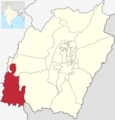
 Churachandpur in Manipur (India).svg 612 × 641; 442 KB
-
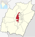
 Imphal East in Manipur (India).svg 612 × 641; 442 KB
-
 Imphal West in Manipur (India).svg 612 × 641; 442 KB
-
 Jiribam in Manipur (India).svg 612 × 641; 442 KB
-
 Kakching in Manipur (India).svg 612 × 641; 442 KB
-
 Kamjong in Manipur (India).svg 612 × 641; 442 KB
-
 Kangpokpi in Manipur (India).svg 612 × 641; 442 KB
-
 Noney in Manipur (India).svg 612 × 641; 442 KB
-
 Pherzawl District.png 1,144 × 1,198; 232 KB
-
 Pherzawl in Manipur (India).svg 612 × 641; 442 KB
-
 Senapati in Manipur (India).svg 612 × 641; 442 KB
-
 Tamenglong in Manipur (India).svg 612 × 641; 442 KB
-
 Tengnoupal in Manipur (India).svg 612 × 641; 442 KB
-
 Thoubal in Manipur (India).svg 612 × 641; 442 KB
-
 Ukhrul in Manipur (India).svg 612 × 641; 442 KB
.svg)
.svg)
.svg)
.svg)
.svg)
.svg)
.svg)
.svg)
.svg)
.svg)

.svg)
.svg)
.svg)
.svg)
.svg)
.svg)