Category:Road maps of Interstate Highways in Michigan
Jump to navigation
Jump to search
States of the United States: Alabama · Alaska · Arizona · Colorado · Florida · Hawaii · Idaho · Iowa · Louisiana · Maryland · Michigan · Nevada · New Jersey · New Mexico · New York · North Carolina · Pennsylvania · South Carolina · South Dakota · Utah · Wyoming
Subcategories
This category has only the following subcategory.
Media in category "Road maps of Interstate Highways in Michigan"
The following 15 files are in this category, out of 15 total.
-
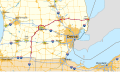 I-69 MI map.svg 1,028 × 610; 2.66 MB
-
 I-196 map.svg 1,026 × 608; 5.93 MB
-
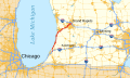
 I-275 MI map.svg 1,026 × 608; 833 KB
-
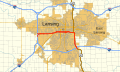 I-496 map.svg 1,026 × 608; 4.66 MB
-
 I-696 map.svg 1,026 × 608; 5.1 MB
-
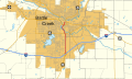 I-194 MI map.svg 1,027 × 609; 828 KB
-
 I-296 map.svg 1,027 × 609; 1.11 MB
-
 I-375 MI map.svg 1,027 × 609; 333 KB
-
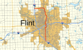 I-475 MI map.svg 1,027 × 609; 3.06 MB
-
 I-675 MI map.svg 1,027 × 609; 668 KB
-
 I-75 MI map.svg 1,027 × 609; 2.82 MB
-
 I-94 MI map.svg 1,027 × 609; 1.31 MB
-
 I-96 MI map.svg 1,027 × 609; 1.27 MB
-
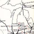 Interstate Highway plan June 27, 1958 (MI).jpg 216 × 216; 10 KB
-
 Michigan Interstates.svg 709 × 709; 4.52 MB


.jpg)
