Category:Recovery Plan
Jump to navigation
Jump to search
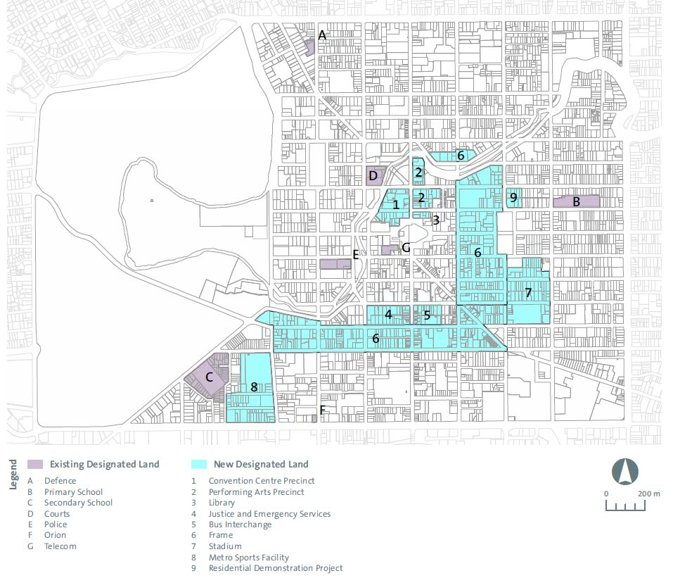
English: The Recovery Plan is a statutory document guiding the recovery of the Christchurch Central City after the earthquakes that started in 2010. The map below shows those projects for which land had to be designated. Missing from the map is the earthquake memorial, as its location was decided on two years after the plan got published.
plan for rebuilding central Christchurch after the 2011 earthquake, comprising 17 anchor projects | |||||
| Upload media | |||||
| Instance of |
| ||||
|---|---|---|---|---|---|
| Part of |
| ||||
| Author | |||||
| Has part(s) |
| ||||
| Publication date |
| ||||
| |||||
Subcategories
This category has the following 17 subcategories, out of 17 total.
Media in category "Recovery Plan"
The following 12 files are in this category, out of 12 total.
-
2020 07Jul timeline.jpg 1,700 × 609; 181 KB
-
3D JPG Book Cover Image.jpg 3,000 × 2,000; 1.12 MB
-
Chch Central Recovery Plan 324.jpg 2,730 × 2,570; 736 KB
-
Chch recovery planning map (cropped).jpg 664 × 621; 116 KB
-
Chch recovery planning map (Metro Sports Facility).jpg 127 × 140; 10 KB
-
Chch recovery planning map (northern crop).jpg 213 × 114; 14 KB
-
Chch recovery planning map (southern designations).jpg 301 × 168; 23 KB
-
Chch recovery planning map.jpg 957 × 821; 157 KB
-
Christchurch-central-recovery-plan-anchor-project-map-a3-1 (cropped).jpg 1,891 × 1,330; 115 KB
-
Christchurch-central-recovery-plan-anchor-project-map-a3-1.jpg 3,308 × 2,339; 793 KB
-
Crowne Plaza Christchurch map.jpg 756 × 720; 94 KB


