Category:Rail transport maps of South Africa
Jump to navigation
Jump to search
Media in category "Rail transport maps of South Africa"
The following 44 files are in this category, out of 44 total.
-

-
 Avontuur railway map.png 1,057 × 370; 278 KB
-
 Cape Colony railways map 1910.svg 827 × 726; 224 KB
-
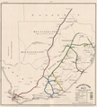
 Cape Government Railways map - 1882 - Cape Archives.jpg 981 × 774; 116 KB
-
 Cape Govt Railways map 1910.svg 827 × 726; 286 KB
-
 Cape Main Line map.svg 1,070 × 934; 408 KB
-
 Central South African Railways map 1910 new lines.svg 778 × 771; 155 KB
-
 Central South African Railways map 1910.svg 778 × 771; 162 KB
-
 Estcourt–Weenen Narrow Gauge Line (OpenStreetMap 445319).jpg 806 × 658; 132 KB
-
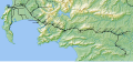
 George-Knysna map.png 868 × 606; 302 KB
-
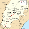
 Manganese export line.png 980 × 1,146; 222 KB
-
 Maseru railway line map.svg 1,529 × 392; 1.33 MB
-
 Metrorail Cape Town.png 1,550 × 660; 79 KB
-
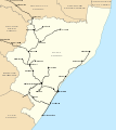
 Metrorail Durban.png 960 × 961; 69 KB
-
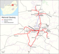
 Metrorail Gauteng.png 2,000 × 1,128; 147 KB
-
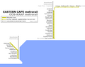 Metrorail ooskaap.png 793 × 618; 32 KB
-
 Natal main line 1910.svg 730 × 822; 592 KB
-
 Natal Railway.svg 539 × 575; 1,020 KB
-
 Natal railways map 1910.svg 730 × 822; 79 KB
-
 Network metrorail gauteng.png 968 × 892; 495 KB
-
 NGR railways map final.svg 730 × 822; 79 KB
-
 NZASM line map.svg 982 × 611; 111 KB
-
 Overberg railway line map.svg 1,140 × 526; 1.28 MB
-
 OVGS Network.svg 778 × 771; 155 KB
-
 Port Alfred railway line map.svg 1,069 × 561; 1.56 MB
-
 Rail map of South Africa - Railroad and Engineering Journal v66 n12 p571.jpg 1,232 × 1,215; 98 KB
-
 Railroads of South Africa, 1950 - DPLA - 669f35bfe2b98dda79fa9a75568ec1d6.jpg 11,196 × 6,653; 7.24 MB
-
 Railway Map of South Africa.jpg 575 × 641; 72 KB
-
 Richards Bay Coal Line.png 838 × 979; 263 KB
-
 Shosholoza Meyl all stations 2010.svg 1,000 × 786; 961 KB
-
 Shosholoza Meyl main stations 2010.svg 1,000 × 786; 540 KB
-
 Shosholoza Meyl roete 2012.svg 1,070 × 934; 322 KB
-
 Shosholoza Meyl routes 2012.svg 1,070 × 934; 321 KB
-
 South Africa and its future (1903) (14781965042).jpg 3,248 × 1,932; 534 KB
-
 South Africa rail network catenary voltage.svg 1,070 × 934; 535 KB
-
 South Africa rail network map with cities.svg 1,070 × 934; 407 KB
-
 South Africa rail network map.svg 1,070 × 934; 230 KB
-
 South Africa railways map 1910.svg 1,070 × 934; 322 KB
-
 SouthernAfricaRailwayMap 1901.png 4,805 × 5,312; 19.22 MB
-
 Swazilink.png 838 × 871; 247 KB
-
 Transvaal railway map 1899 PPR.svg 982 × 611; 94 KB
-
 Transvaal railway map 1899.svg 982 × 611; 104 KB
-
 West Coast railway line map.svg 467 × 1,286; 3.4 MB
-
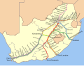
 Western Cape rail network map.svg 868 × 691; 95 KB
.jpg)


.jpg)


_(14781965042).jpg)


