Category:Rail transport maps of Loir-et-Cher
Jump to navigation
Jump to search
Media in category "Rail transport maps of Loir-et-Cher"
The following 7 files are in this category, out of 7 total.
-
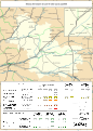 Railway map of France - 41 - 1900 - fr - small.svg 705 × 985; 8.03 MB
-
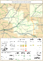
 Railway map of France - 41 - 1913 - fr - small.svg 705 × 985; 8.2 MB
-
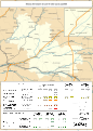
 Railway map of France - 41 - 1930 - fr - small.svg 705 × 985; 8.16 MB
-
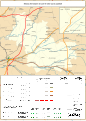
 Railway map of France - 41 - 1980 - fr - small.svg 705 × 985; 8.1 MB
-
 Railway map of France - 41 - 2020 - fr - small.svg 705 × 985; 7.85 MB
-
 Railway map of France - 41 - animated - fr.gif 1,566 × 2,188; 5.82 MB
-
 VFIL Loir&Cher 1928.jpg 3,009 × 1,939; 1.11 MB


