Category:Rail transport maps of Ireland
Jump to navigation
Jump to search
Media in category "Rail transport maps of Ireland"
The following 58 files are in this category, out of 58 total.
-
 10 of 'Guide to Ireland. (With illustrations.)' (11247725176).jpg 2,471 × 2,880; 1.8 MB
-
 1853 Wyld Pocket or Case Map of Ireland - Geographicus - Ireland-wyld-1853.jpg 4,000 × 5,162; 5.83 MB
-
 GODKIN&WALKER(1871) MAP OF IRELAND.jpg 3,183 × 4,261; 5.53 MB
-
 Great Southern and Western Railway system in 1898.jpg 3,402 × 3,842; 2.54 MB
-
 Athenry rail connecctions from RJD 128.jpg 1,110 × 1,078; 276 KB
-
 Bantry map of Railway Tracks.jpg 700 × 540; 155 KB
-
 Belfast Commuter Rail Map.svg 138 × 113; 68 KB
-
 Cavan and Leitrim.jpg 503 × 342; 64 KB
-
 CDRmap.png 4,167 × 2,375; 681 KB
-
 Claremorris rail connections from RJD 128.jpg 996 × 1,409; 344 KB
-
 Collooney Rail Connections.jpg 1,197 × 1,050; 305 KB
-
 Connemara branchlines map 1906.png 1,000 × 1,000; 165 KB
-
 Cork and muskerry light railway.png 4,221 × 2,920; 89 KB
-
 Cork and Youghal Railway (from Viceregal Commission 1906 map).jpg 474 × 267; 31 KB
-
 Cork, Bandon & South Coast Railway.jpg 684 × 330; 100 KB
-
 Córas Iompair Éireann network map 1950s.jpg 2,550 × 3,300; 1.34 MB
-
 DART路線地図.png 2,000 × 2,528; 736 KB
-
 DRRT new.svg 1,080 × 748; 205 KB
-
 Dublin Cork Main Line.svg 3,893 × 4,786; 13.29 MB
-
 Dublin Rail Network2.png 2,599 × 1,801; 418 KB
-
 Dublin Rail Network3.png 3,250 × 2,252; 418 KB
-
 Dublin Rail Network3.svg 780 × 541; 58 KB
-
 Dublin-Galway Mainline.png 3,893 × 4,786; 3.04 MB
-
 Dublin-Rosslare Mainline.png 2,526 × 2,730; 1.15 MB
-
 DV405 no.186 Railway map of Ireland.png 1,279 × 1,679; 6.16 MB
-
 Galway to Clifden Railway 1906 with road connections to Westport.png 800 × 600; 88 KB
-
 Greatest extent of railways in Ulster.svg 716 × 607; 1.39 MB
-
 Harness Ireland Railroad Map 1838.png 2,000 × 2,514; 7.59 MB
-
 Intercity train 2006.gif 493 × 569; 24 KB
-
 Ireland rail network sb.svg 2,268 × 2,801; 468 KB
-
 Ireland rail network.png 343 × 435; 27 KB
-
 Ireland rail network.svg 930 × 1,100; 161 KB
-
 Ireland Railways 1906.pdf 1,754 × 2,481; 1.65 MB
-
 IrishRailMapUpdated2023.png 800 × 988; 248 KB
-
 Map of Belfast & County Down Railway 1926.jpg 896 × 1,314; 307 KB
-
 Map of Cork, Bandon and South Coast Railway 1920.jpg 3,544 × 2,376; 1.02 MB
-
 Map of Dublin and South Eastern Railway 1920.jpg 2,224 × 3,263; 752 KB
-
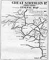 Map of Great Northern Railway (Ireland) 1926.jpg 911 × 1,116; 263 KB
-
 Map of Great Southern and Western Railway 1920.jpg 1,912 × 1,324; 572 KB
-
 Map of Great Southern Railways 1926.jpg 1,340 × 1,773; 712 KB
-
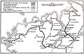 Map of Londonderry & Lough Swilly Railway 1926.jpg 3,432 × 2,216; 793 KB
-
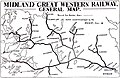 Map of Midland Great Western Railway 1920.jpg 3,448 × 2,232; 1.16 MB
-
 Map of Northern Counties Committee 1926.jpg 2,960 × 1,720; 471 KB
-
 Map of Waterford, Limerick and Western Railway 1895.jpg 4,189 × 5,376; 3.72 MB
-
 Map Rail Ireland Viceregal Commission 1906.jpg 3,063 × 4,167; 897 KB
-
 NI Railways Map.svg 692 × 548; 71 KB
-
 Northern Ireland rail network sb.svg 2,275 × 1,238; 453 KB
-
 Palace East DSER Rail Connections.jpg 885 × 809; 208 KB
-

-
 Rail transport infrastructure map - Entire Ireland.svg 1,360 × 1,701; 10.86 MB
-
 Rail transport infrastructure map - Republic of Ireland.svg 1,247 × 1,701; 10.29 MB
-
 Railway Map of Great Britain, 1915.jpg 3,456 × 4,608; 4.99 MB
-
 Roell-1912 Karte der Britischen und Irischen Eisenbahnen.jpg 3,456 × 4,734; 1.77 MB
-
 Tourist map of Dublin, Wicklow, and Wexford Railway 1895.jpg 2,304 × 3,268; 1.22 MB
-
 Tralee and Dingle light railway.png 4,198 × 2,714; 126 KB
-
 Tralee and Dingle light railway.svg 981 × 635; 27 KB
-
 Tralee rail connection early 1900s from RJD 128.jpg 1,232 × 966; 287 KB
-
 Ulster's railways 1835-2023.gif 2,325 × 1,965; 8.65 MB
%27_(11247725176).jpg)

_MAP_OF_IRELAND.jpg)


.jpg)


_1926.jpg)


_Company%27s_illustrated_guide_to_the_sporting_and_touring_grounds_of_the_north_of_Ireland_(1908)_(14593750589).jpg)


