Category:Public transport maps of Indonesia
Jump to navigation
Jump to search
Subcategories
This category has the following 4 subcategories, out of 4 total.
J
P
R
Y
Media in category "Public transport maps of Indonesia"
The following 19 files are in this category, out of 19 total.
-
 02 Peta Jaringan Transportasi Umum Metropolitan Surabaya.jpg 6,612 × 4,483; 1.41 MB
-
 Bima Train Map.png 1,280 × 1,280; 90 KB
-
 Commuter rail map of Greater Surabaya.jpg 4,961 × 7,028; 4.58 MB
-
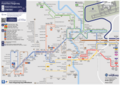
 Diagram Integrasi Transportasi Publik Semarang.png 14,032 × 9,922; 2.51 MB
-
 Dishub TransJogja Route Map 2017.jpg 5,039 × 3,781; 1.27 MB
-
 Map Transport of Surabaya.jpg 10,630 × 8,268; 10.43 MB
-
 Map Transport of Surabaya.png 21,260 × 16,535; 3.62 MB
-
 Pelni Schifffahrtsnetz 2006.png 2,223 × 1,009; 425 KB
-
 Peta Jaringan Transportasi Semarang.svg 2,816 × 1,991; 10.4 MB
-
 Peta Transportasi Umum Yogyakarta 11 September 2023.png 7,016 × 4,961; 5.64 MB
-
 Peta Transportasi Umum Yogyakarta 8 Maret 2024-1-1.png 4,678 × 3,308; 2.03 MB
-
 Peta Transportasi Umum Yogyakarta 8 Maret 2024.png 7,016 × 4,961; 2.92 MB
-
 Peta Transportasi Umum Yogyakarta Feb 2022.png 6,436 × 6,012; 3.87 MB
-
 Peta Transportasi Umum Yogyakarta Januari 2023.png 7,016 × 4,961; 4.15 MB
-
 Public Transport Map of Surakarta.svg 2,105 × 1,488; 2.94 MB
-
 Trans Metro Pasundan Network Map.png 10,000 × 2,500; 665 KB
-
 Trans Metro Pasundan Network Map.svg 512 × 128; 209 KB
-
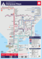 Transit Network Map of Denpasar Metro.png 4,961 × 7,016; 2.15 MB
-
 Transit Network Map of Tangerang.png 10,524 × 7,441; 4.86 MB


