Category:Porte Saint-Paul (Route de la Croix 1, Saint-Ursanne)
Jump to navigation
Jump to search
| Object location | | View all coordinates using: OpenStreetMap |
|---|
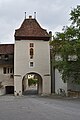
city gate in Saint-Ursanne in the canton of Jura, Switzerland  | |||||
| Upload media | |||||
| Instance of | |||||
|---|---|---|---|---|---|
| Part of |
| ||||
| Location | Saint-Ursanne, Clos du Doubs, Porrentruy District, Jura, Switzerland | ||||
| Street address |
| ||||
 | |||||
Media in category "Porte Saint-Paul (Route de la Croix 1, Saint-Ursanne)"
The following 8 files are in this category, out of 8 total.
-
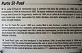 Informations sur la porte Saint-Paul.jpg 3,824 × 2,466; 2.85 MB
-
 Porte Saint-Paul, vue de l'extérieur.jpg 3,748 × 2,804; 3.95 MB
-
 Porte Saint-Paul, vue de l'intérieur.jpg 3,000 × 4,000; 3.75 MB
-
 Saint-Ursanne 2679.jpg 2,592 × 3,888; 3.62 MB
-
 Saint-Ursanne Porte Saint-Paul from the old city.jpg 4,000 × 6,000; 16.68 MB
-
 Saint-Ursanne Porte Saint-Paul.jpg 4,000 × 6,000; 15.76 MB
-
 St-Ursanne-Porte-St-Paul-Detail.jpg 386 × 578; 174 KB
-
 St-Ursanne-Porte-St-Paul.jpg 792 × 792; 548 KB


