Category:Fortifications (Saint-Ursanne)
Jump to navigation
Jump to search
| Object location | | View all coordinates using: OpenStreetMap |
|---|
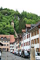
fortifications embracing the old town of Saint-Ursanne in the canton of Jura, Switzerland  | |||||
| Upload media | |||||
| Instance of | |||||
|---|---|---|---|---|---|
| Part of | |||||
| Location | Saint-Ursanne, Clos du Doubs, Porrentruy District, Jura, Switzerland | ||||
| Street address |
| ||||
| Has part(s) | |||||
| Heritage designation | |||||
 | |||||
Subcategories
This category has the following 3 subcategories, out of 3 total.
Media in category "Fortifications (Saint-Ursanne)"
This category contains only the following file.
-
 Saint-Ursanne ville 01.jpg 2,592 × 3,888; 4.38 MB