Category:Poling, West Sussex
Jump to navigation
Jump to search
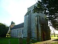
English: Poling is a village and small civil parish in the Arun District of West Sussex, England, located on a road to the south of the A27 road three miles (4.8 km) east of Arundel. The village is small, although there are two Grade I Listed buildings: the Anglican parish church of St Nicholas, in the graveyard of which, Colin Cowdrey, the cricketing legend is remembered, and some remains of St John's Priory (founded by the Knights Hospitallers) alongside the main road. Many of the cottages are also Grade II listed.
village in the United Kingdom  | |||||
| Upload media | |||||
| Instance of | |||||
|---|---|---|---|---|---|
| Location | Arun, West Sussex, South East England, England | ||||
| Population |
| ||||
| Area |
| ||||
 | |||||
Subcategories
This category has the following 2 subcategories, out of 2 total.
N
S
Media in category "Poling, West Sussex"
The following 106 files are in this category, out of 106 total.
-
 A27 - geograph.org.uk - 6444379.jpg 1,024 × 681; 119 KB
-
 A27, Poling Copse - geograph.org.uk - 3081877.jpg 640 × 481; 498 KB
-
 A27, Poling Corner - geograph.org.uk - 3683436.jpg 640 × 430; 56 KB
-

-
 Beech plantation near Poling Corner - geograph.org.uk - 1886753.jpg 640 × 428; 172 KB
-
 Beech plantation near Poling Corner - geograph.org.uk - 5699744.jpg 640 × 428; 204 KB
-
 Bend in Poling Street at Poling - geograph.org.uk - 3028769.jpg 3,264 × 2,448; 5.12 MB
-
 Better late than never - geograph.org.uk - 2289383.jpg 487 × 640; 118 KB
-
 Blakehurst Lane - geograph.org.uk - 3618056.jpg 640 × 480; 111 KB
-
 Blakehurst Lane - geograph.org.uk - 6444380.jpg 1,024 × 681; 161 KB
-
 Blakehurst Lane approaching its junction with the A27 - geograph.org.uk - 2484501.jpg 4,000 × 3,000; 3.37 MB
-
 Blakehurst Lane north to Blakehurst Farm - geograph.org.uk - 2484518.jpg 4,000 × 3,000; 3.52 MB
-

-
 Bungalow on Poling Street - geograph.org.uk - 5843450.jpg 2,048 × 1,536; 1.85 MB
-
 Burnt out Fiesta in Sailor's Copse - geograph.org.uk - 2484373.jpg 4,000 × 3,000; 3.63 MB
-
 Chain Home radar installation at Poling, Sussex, 1945. CH15173.jpg 3,244 × 2,480; 2.05 MB
-
 Colin Cowdrey's grave - geograph.org.uk - 1943457.jpg 640 × 428; 157 KB
-
 Crossbush Lane - geograph.org.uk - 3081874.jpg 640 × 481; 543 KB
-
 Crossbush Lane - geograph.org.uk - 5699550.jpg 640 × 428; 190 KB
-
 Crossing of Footpaths - geograph.org.uk - 3618035.jpg 640 × 480; 117 KB
-
 Curious cattle - geograph.org.uk - 1943416.jpg 640 × 428; 100 KB
-
 Entering Angmering Park Estate - geograph.org.uk - 2006129.jpg 2,048 × 1,536; 672 KB
-
 Entering Poling - geograph.org.uk - 1254904.jpg 480 × 640; 137 KB
-
 Farm in Poling - geograph.org.uk - 5843452.jpg 1,986 × 1,448; 1.42 MB
-
 Farm Track near Poling - geograph.org.uk - 1251056.jpg 480 × 640; 132 KB
-
 Flint barn, Poling, West Sussex - geograph.org.uk - 3355895.jpg 1,600 × 815; 308 KB
-
 Footbridge over the Black Ditch - geograph.org.uk - 1943408.jpg 640 × 428; 131 KB
-
 Footbridge over the Black Ditch - geograph.org.uk - 1943472.jpg 640 × 428; 124 KB
-
 Footpath 2201 approaching Manor Farm and Poling - geograph.org.uk - 3375790.jpg 4,320 × 3,240; 5.12 MB
-
 Footpath 2201 to Decoy Wood - geograph.org.uk - 1890085.jpg 2,048 × 1,536; 644 KB
-

-
 Footpath crossways, Poling Copse - geograph.org.uk - 1886791.jpg 640 × 428; 189 KB
-
-

-
 Footpath junction at field edge - geograph.org.uk - 4761524.jpg 800 × 600; 217 KB
-
 Footpath junction in Poling Copse - geograph.org.uk - 2484537.jpg 4,000 × 3,000; 3.6 MB
-
 Footpath leaves bridleway east of Poling - geograph.org.uk - 4761393.jpg 800 × 600; 103 KB
-
-
 Footpath sign near St Nicholas, Poling - geograph.org.uk - 2339842.jpg 640 × 480; 101 KB
-
 Footpath to Blakehurst Lane - geograph.org.uk - 3618042.jpg 640 × 480; 129 KB
-
 Footpath to Reed's Copse - geograph.org.uk - 2959212.jpg 1,600 × 1,200; 976 KB
-
 Footpath to St Nicholas Church Poling - geograph.org.uk - 3028776.jpg 3,264 × 2,448; 5.44 MB
-
 Footpath, South Fields - geograph.org.uk - 2959189.jpg 1,600 × 1,200; 924 KB
-
 Free flowing drainage ditch - geograph.org.uk - 3375807.jpg 4,320 × 3,240; 4.82 MB
-
 House at Poling.JPG 2,048 × 1,536; 978 KB
-
 Houses on Poling Street - geograph.org.uk - 4761643.jpg 800 × 600; 159 KB
-

-
 Looking north on Poling Street - geograph.org.uk - 1889941.jpg 2,048 × 1,536; 666 KB
-
 Looking north on Poling Street - geograph.org.uk - 4761647.jpg 800 × 600; 131 KB
-

-
 Man made pond east of Poling - geograph.org.uk - 3375782.jpg 4,320 × 3,240; 4.74 MB
-
 Manor House Poling - geograph.org.uk - 1998896.jpg 3,648 × 2,736; 4.18 MB
-
 Market gardening, Poling - geograph.org.uk - 1943435.jpg 640 × 428; 103 KB
-
 Millennium Monument, Poling Corner - geograph.org.uk - 1251163.jpg 480 × 640; 184 KB
-
 Mole crossing - geograph.org.uk - 2484529.jpg 4,000 × 3,000; 3.51 MB
-
 New Barn, Manor Farm - geograph.org.uk - 1254983.jpg 640 × 480; 125 KB
-
 Newhouse Buildings - geograph.org.uk - 1251087.jpg 480 × 640; 73 KB
-
 Newhouse Buildings - geograph.org.uk - 1251110.jpg 640 × 488; 68 KB
-

-
 Out-building, St. John's Priory, Poling - geograph.org.uk - 3464342.jpg 1,600 × 1,048; 324 KB
-
 Path in Poling Copse - geograph.org.uk - 5699650.jpg 640 × 428; 181 KB
-
 Path in Poling Copse - geograph.org.uk - 5699651.jpg 640 × 428; 202 KB
-
 Path south through Westlands Copse - geograph.org.uk - 2477270.jpg 4,000 × 3,000; 3.68 MB
-
 Pillbox under restoration - geograph.org.uk - 1889904.jpg 2,048 × 1,536; 708 KB
-
 Poling church - geograph.org.uk - 4761433.jpg 800 × 600; 122 KB
-
 Poling Corner on the A27 - geograph.org.uk - 5822459.jpg 2,048 × 1,536; 1.53 MB
-
 Poling Street - geograph.org.uk - 1251068.jpg 480 × 640; 104 KB
-
 Poling Street - geograph.org.uk - 1251117.jpg 480 × 640; 88 KB
-
 Poling Street - geograph.org.uk - 1254934.jpg 640 × 508; 93 KB
-
 Poling Street - geograph.org.uk - 5838544.jpg 2,048 × 1,536; 1.58 MB
-
 Poling Street, Poling, West Sussex - geograph.org.uk - 3355903.jpg 1,600 × 1,051; 453 KB
-
 Pond by footpath - geograph.org.uk - 4761531.jpg 800 × 600; 145 KB
-

-
 Red telephone kiosk and postbox, Poling - geograph.org.uk - 3357233.jpg 1,600 × 955; 346 KB
-
 Remains of a tree, Westlands Copse - geograph.org.uk - 1886769.jpg 640 × 428; 190 KB
-

-
 Rush hour in Poling - geograph.org.uk - 2339867.jpg 640 × 480; 94 KB
-
 Sailor's copse - geograph.org.uk - 2959221.jpg 1,600 × 1,200; 889 KB
-
 Sailors Copse - geograph.org.uk - 3618047.jpg 640 × 480; 173 KB
-
 Shoreham-by-Sea from the air - geograph.org.uk - 5931299.jpg 3,264 × 2,448; 4.31 MB
-
 Sign on footpath west of Poling Street - geograph.org.uk - 4761410.jpg 800 × 600; 153 KB
-
 South to Poling - geograph.org.uk - 1998987.jpg 3,648 × 2,736; 4.14 MB
-

-

-
 Stile and Fingerpost on footpath 2201 - geograph.org.uk - 1890750.jpg 2,048 × 1,536; 686 KB
-
 The A27 at Poling Corner - geograph.org.uk - 5817236.jpg 2,048 × 1,536; 1.49 MB
-
 The font in Poling church - geograph.org.uk - 4761439.jpg 800 × 600; 82 KB
-
 The Manor House - geograph.org.uk - 1254955.jpg 480 × 640; 109 KB
-
 The Old Manor House, Poling - geograph.org.uk - 1294205.jpg 640 × 424; 87 KB
-
 The Old School House, Poling - geograph.org.uk - 1294211.jpg 640 × 424; 130 KB
-
 The old school, Poling - geograph.org.uk - 3355898.jpg 640 × 400; 126 KB
-
 The Old School, Poling - geograph.org.uk - 5817255.jpg 1,976 × 1,436; 1.86 MB
-
 The Old Vicarage, Poling Street - geograph.org.uk - 1251063.jpg 480 × 640; 105 KB
-
 Track in field by Poling Street - geograph.org.uk - 5838686.jpg 1,990 × 1,454; 1.54 MB
-
 Track off Poling Street - geograph.org.uk - 5843451.jpg 2,048 × 1,536; 1.71 MB
-
 Way into Westlands Copse - geograph.org.uk - 5699555.jpg 640 × 428; 198 KB
-
 Wayes End, Poling Street - geograph.org.uk - 1254929.jpg 480 × 640; 133 KB
-
 Woodland bridleway - geograph.org.uk - 5699741.jpg 640 × 428; 206 KB
-
 Woodland by Blakehurst Lane - geograph.org.uk - 6038466.jpg 1,600 × 1,200; 723 KB
-
 Woodland by the A27, Crossbush - geograph.org.uk - 5844618.jpg 2,048 × 1,536; 2.5 MB
-
 Wrecked and burnt out car - geograph.org.uk - 5700050.jpg 640 × 428; 199 KB
-
 Blakehurst Farm - geograph.org.uk - 21798.jpg 640 × 480; 73 KB
-
 Public Footpath and Footbridge - geograph.org.uk - 69185.jpg 640 × 480; 122 KB
-
 The Dover Woodland - geograph.org.uk - 21800.jpg 640 × 480; 127 KB
-
 The Nurseries - geograph.org.uk - 20987.jpg 640 × 480; 62 KB
-
 Towards Black Ditch - geograph.org.uk - 30346.jpg 640 × 480; 82 KB


