Category:Plat book of Huron County, Michigan - also patron's business and general farmer's directory of Huron Co., Mich. - with biographical sketches
Jump to navigation
Jump to search
Media in category "Plat book of Huron County, Michigan - also patron's business and general farmer's directory of Huron Co., Mich. - with biographical sketches"
The following 57 files are in this category, out of 57 total.
-
 Map of Bayport, Michigan (1904).jpg 1,766 × 1,814; 1.46 MB
-
 Map of Berne, Michigan (1904).jpg 1,371 × 791; 577 KB
-
 Map of Caseville, Michigan (1904).jpg 3,361 × 2,827; 1.89 MB
-
 Map of Creel City, Michigan (1904).jpg 794 × 984; 113 KB
-
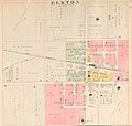 Map of Elkton, Michigan (1904).jpg 2,188 × 2,074; 1.34 MB
-
 Map of Gore Township, Michigan (1904).jpg 1,068 × 1,629; 940 KB
-
 Map of Grindstone City, Michigan (1904).jpg 2,071 × 1,657; 1.91 MB
-
 Map of Kilmanagh, Michigan (1904).jpg 779 × 578; 280 KB
-
 Map of Kinde, Michigan (1904).jpg 1,448 × 1,185; 931 KB
-
 Map of Linkville, Michigan (1904).jpg 949 × 791; 433 KB
-
 Map of Owendale, Michigan (1904).jpg 1,016 × 1,322; 158 KB
-
 Map of Pigeon, Michigan (1904).jpg 2,178 × 1,819; 485 KB
-
 Map of Pinnebog, Michigan (1904).jpg 777 × 789; 278 KB
-
 Map of Port Crescent, Michigan (1904).jpg 1,027 × 1,203; 151 KB
-
 Map of Ruth, Michigan (1904).jpg 1,082 × 870; 402 KB
-
 Map of Ubly, Michigan (1904).jpg 2,621 × 1,495; 1.9 MB
-
-

-

-

-

-

-

-
-

-

-

-

-

-

-

-

-

-

-

-
-

-

-

-

-

-

-

-

-

-

-

-

-

-

-

-

-

-

-

-

-

.jpg)
.jpg)
.jpg)
.jpg)
.jpg)
.jpg)
.jpg)
.jpg)
.jpg)
.jpg)
.jpg)
.jpg)
.jpg)
.jpg)
.jpg)
.jpg)


