Category:Photos from Norman B. Leventhal Map Center at the BPL's photostream
Jump to navigation
Jump to search
Subcategories
This category has the following 5 subcategories, out of 5 total.
Media in category "Photos from Norman B. Leventhal Map Center at the BPL's photostream"
The following 200 files are in this category, out of 4,046 total.
(previous page) (next page)-
 "Alas, poor Yorick!"-from the painting by Horace Fisher (28004025095).jpg 2,000 × 1,362; 2.58 MB
-
 "Texas New Yorker" travelers' railroad map of the State of Texas (11840363764).jpg 1,420 × 2,000; 2.87 MB
-

-
-
 (Embroidered Terrestrial Globe) (26665113080).jpg 1,800 × 1,197; 1.08 MB
-

-
 (Illustrations of Shakespeare's house and school) (28004023965).jpg 2,000 × 1,427; 2.91 MB
-

-

-

-

-
 (Title page for volume one) Atlantic Neptune (10295140453).jpg 591 × 800; 98 KB
-
 A topographical map of the northn. part of New York Island... (2674343553).jpg 1,371 × 2,000; 2.23 MB
-
 1814 BenjaminDearborn Boston map3856248942.jpg 1,615 × 2,000; 2.88 MB
-
 1835 SouthCove map Boston BPL 2675248746.jpg 1,882 × 1,028; 1.1 MB
-
 1836 Provincetown US Topographical Bureau.jpg 5,760 × 4,800; 1.29 MB
-
 1837 SouthCove plan Boston BPL 2674636813.jpg 2,000 × 1,298; 2.03 MB
-
 1838 A map of Cambridge, Mass. (9474974242).jpg 800 × 578; 81 KB
-
 1839 map Boston Deaborn 2674434011.jpg 1,901 × 2,000; 3.89 MB
-
 1850 NathDearborn Boynton map Boston2674451953.jpg 1,794 × 2,000; 3.81 MB
-
 1854 Map of the city of Cambridge, Middlesex County, Massachusetts (3887215674).jpg 2,000 × 1,680; 3.14 MB
-
 1857 Map of the town of Sandwich, Barnstable County, Mass. (6094146242).jpg 10,259 × 7,670; 11.09 MB
-
 1859 Gloucester Harbour, Village (2675625252).jpg 2,000 × 1,455; 2.43 MB
-
 1859 NorthSt Boston map.jpg 2,000 × 782; 1.17 MB
-
 1859 Plan of Boston comprising a part of Charlestown and Cambridge (2674457079).jpg 1,627 × 2,000; 3.33 MB
-
 1873 map of Sinai Peninsula during Exodus.jpg 1,766 × 2,118; 977 KB
-
 1873 map of the travels of Apostle Paul.jpg 2,371 × 1,741; 1.04 MB
-
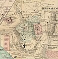 1873 plan of Jerusalem's holy places.jpg 1,647 × 1,689; 907 KB
-
 1876 bird's eye view of Lowell, Massachusetts; colored.jpg 9,768 × 7,272; 19.3 MB
-
 1903 Map of Salem and surrounding places (7557369652).jpg 7,605 × 5,602; 41.1 MB
-

-
 25 miles around Richmond. Grant's campaign war map, supplement.jpg 2,000 × 1,725; 2.82 MB
-

-
 A block of 6 brick houses, the property of Isaac Stebbins Esquire (3369704291).jpg 2,000 × 1,820; 2.99 MB
-
 A chart of Boston Bay (2674893303).jpg 2,000 × 1,395; 2.03 MB
-

-

-
 A chart of Montego Bay on the north west shore of the Island of Jamaica (3046595634).jpg 1,500 × 2,000; 2.71 MB
-
 A chart of Nantucket shoals (3045498021).jpg 2,000 × 1,316; 2.45 MB
-
 A chart of South Carolina and Georgia (3045498341).jpg 1,629 × 2,000; 3.15 MB
-
 A chart of South Carolina and Georgia (3045543193).jpg 1,655 × 2,000; 3.16 MB
-

-
 A chart of the banks of Newfoundland (3045499021).jpg 2,000 × 1,307; 2.58 MB
-
 A chart of the Caribe islands (8429866373).jpg 800 × 684; 127 KB
-
 A chart of the Caribe Islands (9495452356).jpg 800 × 644; 142 KB
-
 A chart of the coast of America from New found Land to Cape Cod (2675728104).jpg 2,000 × 1,611; 3.23 MB
-
 A chart of the coast of America from Wood Island to Good Harbor (3046378936).jpg 2,000 × 1,284; 2.29 MB
-

-
 A chart of the coast of Maine (8347484366).jpg 799 × 592; 131 KB
-
-

-
 A chart of the Gulf Stream inverted right to left (8475486331).jpg 800 × 610; 112 KB
-
 A chart of the harbour of Boston (3046534442).jpg 2,000 × 1,385; 2.6 MB
-

-

-
 A chart of the harbour of Rhode Island and Narraganset Bay (3045761151).jpg 1,381 × 2,000; 2.44 MB
-
 A chart of the iland of Hispaniola (9495452500).jpg 800 × 645; 159 KB
-
 A chart of the Island of Cape Breton (3046597808).jpg 1,473 × 2,000; 2.86 MB
-

-

-

-

-

-

-
 A chart of the sea coast of New Foundland... (2674910301).jpg 2,000 × 1,599; 3 MB
-
 A chart of the South Sea (8429866651).jpg 800 × 692; 145 KB
-
 A chart of the streights of Bell Isle (3046379564).jpg 2,000 × 1,640; 3.16 MB
-

-
 A chart of the West Indies, from the latest marine journals and surveys (3046155962).jpg 2,000 × 1,602; 2.87 MB
-

-

-

-
-
 A cidade de Angra na ilha de Iesu xpō da Tercera que esta em 39. graos (2674179947).jpg 1,798 × 1,036; 2.42 MB
-

-
 A comprehensive atlas, geographical, historical & commercial (2709985251).jpg 2,000 × 1,286; 1.66 MB
-

-
 A correct map of Connecticut from actual survey (4578699907).jpg 2,000 × 1,648; 3.39 MB
-

-

-
-

-
-

-

-
 A draught of Boston Harbor by Capt. Cyprian Southake (3120131115).jpg 2,000 × 1,609; 2.78 MB
-
 A draught of New York from the Hook to New York Town (9495451898).jpg 800 × 638; 121 KB
-
 A draught of the Bay of Honda (9492654209).jpg 508 × 800; 97 KB
-
-
 A draught of the harbour of Hallifax and the adjacent coast in Nova Scotia (2675428704).jpg 2,000 × 1,527; 2.41 MB
-

-
 A front view of the lines taken from the advanced post near Browns house (3045762845).jpg 1,528 × 2,000; 2.38 MB
-
 A general chart of the island of Newfoundland with the rocks & soundings (5960816713).jpg 2,000 × 1,469; 2.44 MB
-
-
 A general map of the northern British colonies in America (2674328921).jpg 2,000 × 1,469; 2.7 MB
-
 A general map of the northern British Colonies in America (2675145130).jpg 2,000 × 1,467; 2.74 MB
-

-
 A general map of the southern British colonies, in America (2675154484).jpg 2,000 × 1,567; 3.08 MB
-
 A generall chart of the western ocean (9492652695).jpg 799 × 636; 155 KB
-

-

-

-
 A guide to Boston (3121045758).jpg 2,000 × 1,599; 3.15 MB
-
 A humorous diplomatic atlas of Europe and Asia (6093609427).jpg 2,000 × 1,522; 2.95 MB
-

-

-
 A large draft of the island Antegua (9492653741).jpg 512 × 800; 102 KB
-
 A large draught of New England, New York and Long Island (2675697244).jpg 2,000 × 1,616; 3.02 MB
-

-

-
-
-
 A map of 100 miles round Boston (2674993914).jpg 2,000 × 1,874; 3.34 MB
-

-
 A map of Canaan (8343807206).jpg 7,062 × 5,759; 38.43 MB
-
 A map of Chili, Patagonia, La Plata and ye south part of Brasil.jpg 1,445 × 2,000; 2.87 MB
-
 A map of Fitchburg, Mass. (2674581312).jpg 1,601 × 2,000; 2.68 MB
-
 A map of Friends settlement, in the township of Le Ray Jefferson Co (4579315954).jpg 4,064 × 3,603; 6.34 MB
-
 A map of Ireland according to the best authorities (3045238263).jpg 3,890 × 4,343; 3.93 MB
-
 A map of Louisiana and of the River Mississipi (4231931192).jpg 2,000 × 1,782; 3.83 MB
-
 A Map of Methuen, Mass. (4579319884).jpg 8,761 × 6,392; 15.55 MB
-
 A map of New England and New York (2674918949).jpg 2,000 × 1,517; 2.98 MB
-
 A map of New England and New York (8347484880).jpg 800 × 636; 138 KB
-

-
 A map of New England, being the first that ever was here cut ... places (2675732378).jpg 2,000 × 1,574; 3.04 MB
-
 A map of New York which is published by the Washington Square Bookshop (20549862440).jpg 2,000 × 1,587; 4.32 MB
-

-

-
 A map of part of the N.W. territory of the United States (3045319449).jpg 2,000 × 1,577; 2.8 MB
-
 A map of part of the Viceroyalty of Buenos Ayres (4586557183).jpg 1,126 × 2,000; 1.98 MB
-

-
 A map of Plymouth Village, 1846 (3720083929).jpg 1,024 × 823; 669 KB
-
 A map of South America according to the best authorities (3046155724).jpg 2,000 × 1,743; 3 MB
-

-

-
 A map of the Bermuda Islands - ya des demonios, isles of the devils (20547080228).jpg 2,000 × 1,402; 3.77 MB
-

-

-

-
 A map of the British and French settlements in North America (4071880581).jpg 2,000 × 1,377; 2.87 MB
-
-
-

-

-
 A map of the city of Boston in Massachusetts (3121051048).jpg 2,000 × 1,722; 3.54 MB
-
 A map of the city of Providence (7557381628).jpg 6,430 × 5,328; 32.26 MB
-
 A map of the coast and country about Sierra Lione and Sherbro River (5961368826).jpg 1,525 × 2,000; 2.86 MB
-

-

-

-
 A map of the cotton kingdom and its dependencies in America (5490089850).jpg 2,000 × 1,362; 2.83 MB
-

-
 A map of the countries thirty degrees round the north pole (4071860125).jpg 2,000 × 1,470; 2.75 MB
-

-

-
-

-

-
-
 A map of the eclipse of Feby. 12th in its passage across the United States (7557427744).jpg 6,382 × 7,599; 48.82 MB
-

-
 A map of the extremity of Cape Cod (2674990320).jpg 2,000 × 1,593; 2.07 MB
-
-

-
 A map of the island of St. Domingo (4586550141).jpg 2,000 × 1,336; 1.83 MB
-

-
 A map of the middle British colonies in North America (8642335653).jpg 800 × 494; 108 KB
-
 A map of the most inhabited part of New England (2674889207).jpg 1,942 × 2,000; 3.57 MB
-

-
 A map of the mouth of the River Tagus or the Harbour of the city of Lisbon (8249620173).jpg 2,000 × 1,805; 3.79 MB
-

-

-

-

-

-

-

-
 A map of the State of New York (4584053064).jpg 2,000 × 1,624; 3.66 MB
-
 A map of the state of Pennsylvania (4583423629).jpg 2,000 × 1,339; 2.53 MB
-

-
 A map of the Tennassee state formerly part of North Carolina (3045318235).jpg 2,000 × 1,527; 2.5 MB
-
 A map of the town of Lexington Middlesex County, Mass. (3855458841).jpg 7,272 × 9,310; 10.42 MB
-
 A map of the town of Milford, Worcester County, Massachusetts (3120017239).jpg 1,485 × 2,000; 2.79 MB
-
 A map of the town of Providence from actual survey (4231922514).jpg 10,284 × 7,213; 6.15 MB
-
 A Map of the town of Shrewsbury, Mass. (3719858137).jpg 773 × 1,024; 619 KB
-
 A map of the Town of Shrewsbury, Mass. (3719858383).jpg 858 × 1,024; 702 KB
-
 A map of the towns of Dorchester and Milton, 1831 (2674510092).jpg 2,000 × 1,628; 2.02 MB
-
 A map of the United States of North America (8767917455).jpg 800 × 697; 117 KB
-

-

-

-

-
 A map of the world from the best authorities (4072626080).jpg 2,000 × 1,251; 2.43 MB
-
 A map of the world on a globular projection (2710771418).jpg 1,200 × 668; 178 KB
-
 A map of the Yearly Meeting of Friends for New England (5120540267).jpg 1,459 × 2,000; 2.62 MB
-
 A map of the yearly meeting of Friends for New England A.D. 1833 (5121143798).jpg 1,256 × 2,000; 2.38 MB
-

-
 A map of Virginia and Maryland (5121163162).jpg 2,000 × 1,543; 3.35 MB
-
-
 A mapp of New England (2675735796).jpg 2,000 × 1,665; 2.83 MB
.jpg)
.jpg)
.jpg)
_(14539206087).jpg)
_(26665113080).jpg)
_(28004023615).jpg)
_(28004023965).jpg)
_(10825798246).jpg)
,_between_Avery_and_Eliot_Streets,_and_Tremont_Street_and_Harrison_Avenue)_(10212478055).jpg)
_(14783592658).jpg)
_(10208237386).jpg)
_Atlantic_Neptune_(10295140453).jpg)
.jpg)


.jpg)


.jpg)
.jpg)
.jpg)
.jpg)


.jpg)
.jpg)


.jpg)
.jpg)
.jpg)
.jpg)
.jpg)
.jpg)
.jpg)
.jpg)
.jpg)
.jpg)
.jpg)
.jpg)
.jpg)
.jpg)

.jpg)
.jpg)
.jpg)
.jpg)
.jpg)
.jpg)
.jpg)
.jpg)
.jpg)
.jpg)
.jpg)
.jpg)
.jpg)
.jpg)
.jpg)
.jpg)
.jpg)
.jpg)
.jpg)
.jpg)
.jpg)
.jpg)
.jpg)
.jpg)
.jpg)
.jpg)
.jpg)
.jpg)
.jpg)
.jpg)
.jpg)
.jpg)
.jpg)
.jpg)
.jpg)
.jpg)
.jpg)
.jpg)
.jpg)
.jpg)
.jpg)
.jpg)
.jpg)
.jpg)
.jpg)

.jpg)
.jpg)
.jpg)
.jpg)
.jpg)
.jpg)
.jpg)
.jpg)
.jpg)
.jpg)
_(cropped).jpg)
.jpg)
.jpg)
.jpg)
.jpg)
.jpg)
.jpg)
.jpg)
.jpg)
.jpg)
.jpg)

.jpg)
.jpg)
.jpg)
.jpg)
.jpg)
.jpg)
.jpg)
.jpg)
.jpg)
.jpg)
.jpg)
.jpg)
.jpg)
.jpg)
.jpg)
.jpg)
.jpg)
.jpg)
.jpg)
.jpg)
.jpg)
.jpg)
.jpg)
.jpg)
.jpg)
.jpg)
.jpg)
.jpg)
.jpg)
.jpg)
.jpg)
.jpg)
.jpg)
.jpg)
.jpg)
.jpg)
.jpg)
.jpg)
.jpg)
.jpg)
.jpg)
.jpg)
.jpg)
.jpg)
.jpg)
.jpg)
.jpg)
.jpg)
.jpg)
.jpg)
.jpg)
.jpg)
.jpg)
.jpg)
.jpg)
.jpg)
.jpg)
.jpg)
.jpg)
.jpg)
.jpg)
.jpg)
.jpg)
.jpg)
.jpg)
.jpg)
.jpg)
.jpg)
.jpg)
.jpg)
.jpg)
.jpg)
.jpg)
.jpg)
.jpg)
.jpg)
.jpg)
.jpg)
.jpg)
.jpg)
.jpg)
.jpg)
.jpg)
.jpg)